. 2021 Jun 15;118(24):e2020524118.
doi: 10.1073/pnas.2020524118.

Intracounty modeling of COVID-19 infection with human mobility: Assessing spatial heterogeneity with business traffic, age, and race

Affiliations

Intracounty modeling of COVID-19 infection with human mobility: Assessing spatial heterogeneity with business traffic, age, and race

Xiao Hou et al. Proc Natl Acad Sci U S A. .

Abstract

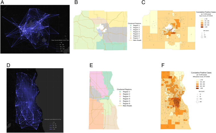
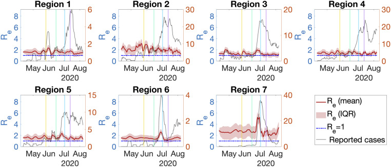
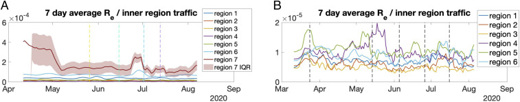
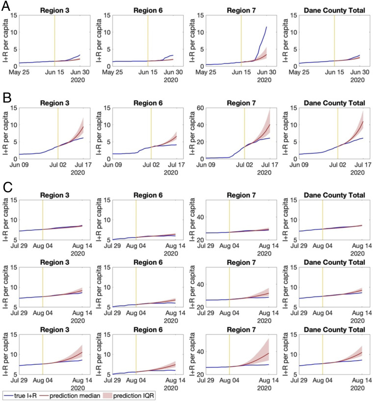
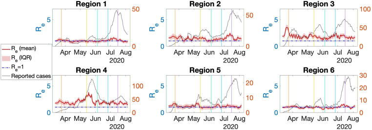
The COVID-19 pandemic is a global threat presenting health, economic, and social challenges that continue to escalate. Metapopulation epidemic modeling studies in the susceptible-exposed-infectious-removed (SEIR) style have played important roles in informing public health policy making to mitigate the spread of COVID-19. These models typically rely on a key assumption on the homogeneity of the population. This assumption certainly cannot be expected to hold true in real situations; various geographic, socioeconomic, and cultural environments affect the behaviors that drive the spread of COVID-19 in different communities. What's more, variation of intracounty environments creates spatial heterogeneity of transmission in different regions. To address this issue, we develop a human mobility flow-augmented stochastic SEIR-style epidemic modeling framework with the ability to distinguish different regions and their corresponding behaviors. This modeling framework is then combined with data assimilation and machine learning techniques to reconstruct the historical growth trajectories of COVID-19 confirmed cases in two counties in Wisconsin. The associations between the spread of COVID-19 and business foot traffic, race and ethnicity, and age structure are then investigated. The results reveal that, in a college town (Dane County), the most important heterogeneity is age structure, while, in a large city area (Milwaukee County), racial and ethnic heterogeneity becomes more apparent. Scenario studies further indicate a strong response of the spread rate to various reopening policies, which suggests that policy makers may need to take these heterogeneities into account very carefully when designing policies for mitigating the ongoing spread of COVID-19 and reopening.

Keywords: data assimilation; human mobility; neighborhood disparities; spatial epidemiology; stochastic COVID-19 spread modeling.


Conflict of interest statement

The authors declare no competing interest.

Figures

Fig. 1.
Fig. 1.
The spatial distributions of (A) human movement O-D flows between census tracts in Dane County, (B) Dane County spatial clustering results using the Walktrap network community detection method, (C) the raw cumulative confirmed COVID-19 cases and ratio of per 10,000 people at the census tract level in Dane County by August 14, 2020, (D) human movement O-D flows between census tracts in Milwaukee County, (E) Milwaukee County spatial clustering results using the Walktrap network community detection method, and (F) the raw cumulative confirmed COVID-19 cases and ratio of per 10,000 people at the census tract level in Milwaukee County by August 12, 2020. (COVID-19 confirmed cases data were retrieved from the Wisconsin Department of Health Services.)
Fig. 2.
Fig. 2.
Effective reproduction number (left y axis) and daily confirmed cases (right y axis) with 7-d average values for different regions in Dane County. The vertical lines indicate the dates of phase 1 reopening, phase 2 reopening, rollback reopening, and face covering order.
Fig. 3.
Fig. 3.
The time-varying effective reproduction number normalized by inner region traffic frequency. (A) The 7-d average Re normalized in Dane County. The yellow, green, blue, and purple vertical lines indicate the date of reopening phase 1, reopening phase 2, rollback of phase 2, and face covering order, respectively. (B) The 7-d average Re normalized in Milwaukee County. The vertical lines indicate the starting date of state of Wisconsin Safer at Home Order, phase 2 reopening, phase 3 reopening, phase 4 reopening, and mask ordinance (from left to right).
Fig. 4.
Fig. 4.
Prediction of cumulative infections (I+R) per 1,000 people in selected regions if Dane County, (A) scenario 1, did not have phase 2 reopening; (B) scenario 2, did not have rollback from phase 2 reopening on July 2; or (C) scenario 3, further reopens on August 4. In C, shown are (Top) reopening with the current effective reproduction number, (Middle) reopening with a doubled effective reproduction number, and (Bottom) reopening with a tripled effective reproduction number.
Fig. 5.
Fig. 5.
Effective reproductive number (7-d average, left y axis) and reported cases (7-d average, right y axis) of region 1 to region 6 in Milwaukee County (left to right, top to bottom). The vertical lines indicate the starting date of state of Wisconsin Safer at Home Order, phase 2 reopening, phase 3 reopening, phase 4 reopening, and mask ordinance (from left to right).
Fig. 6.
Fig. 6.
(Left) Comparison of self-reported social distancing behavior among different age groups. (Right) Comparison of self-reported social distancing behavior among different race and ethnicity groups.

Similar articles

Cited by

References

    1. Centers for Disease Control and Prevention , COVID-19 cases in U.S. Centers for disease control and prevention. https://www.cdc.gov/coronavirus/2019-ncov/cases-updates/cases-in-us.html. Accessed 24 August 2020.
    1. Klompas M., Baker M. A., Rhee C., Airborne transmission of SARS-CoV-2: Theoretical considerations and available evidence. J. Am. Med. Assoc. 324, 441–442 (2020). - PubMed
    1. Balcan D., et al. , Multiscale mobility networks and the spatial spreading of infectious diseases. Proc. Natl. Acad. Sci. U.S.A. 106, 21484–21489 (2009). - PMC - PubMed
    1. Kraemer M. U., et al. , The effect of human mobility and control measures on the COVID-19 epidemic in China. Science 368, 493–497 (2020). - PMC - PubMed
    1. Grantz K. H., et al. , The use of mobile phone data to inform analysis of COVID-19 pandemic epidemiology. Nat. Commun. 11, 1–8 (2020). - PMC - PubMed

Publication types

LinkOut - more resources