. 2021 Jun 21;12(1):3812.
doi: 10.1038/s41467-021-23982-4.

Global coastal attenuation of wind-waves observed with radar altimetry

Affiliations

Global coastal attenuation of wind-waves observed with radar altimetry

Marcello Passaro et al. Nat Commun. .

Abstract

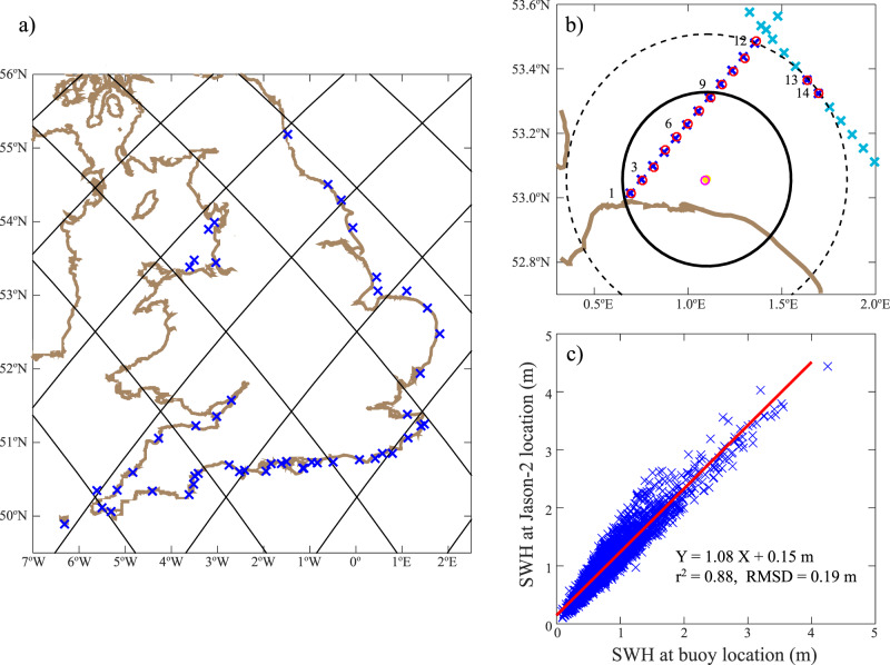
Coastal studies of wave climate and evaluations of wave energy resources are mainly regional and based on the use of computationally very expensive models or a network of in-situ data. Considering the significant wave height, satellite radar altimetry provides an established global and relatively long-term source, whose coastal data are nevertheless typically flagged as unreliable within 30 km of the coast. This study exploits the reprocessing of the radar altimetry signals with a dedicated fitting algorithm to retrieve several years of significant wave height records in the coastal zone. We show significant variations in annual cycle amplitudes and mean state in the last 30 km from the coastline compared to offshore, in areas that were up to now not observable with standard radar altimetry. Consequently, a decrease in the average wave energy flux is observed. Globally, we found that the mean significant wave height at 3 km off the coast is on average 22% smaller than offshore, the amplitude of the annual cycle is reduced on average by 14% and the mean energy flux loses 38% of its offshore value.


Conflict of interest statement

The authors declare no competing interests.

Figures

Fig. 1
Fig. 1. Mean Significant Wave Height (SWH).
Mean SWH from along-track satellite altimetry over the global ocean (a) and along the coastline (b). (c) shows the difference between the offshore and the coastal estimates.
Fig. 2
Fig. 2. Coastal changes of mean Significant Wave Height (SWH).
Examples of coastal changes of mean SWH along the altimetry tracks (colour scale) in Alaska (a), South Australia (b), the island of Java in Indonesia (c) and in Great Barrier Reef region of East Australia (d). Bathymetry contours are plotted at intervals of 60 m from −20 m until −200 m depth and every 200 m until − 2000 m depth. The mean wave direction computed from the ECMWF ERA5 reanalysis is shown with black arrows.
Fig. 3
Fig. 3. Amplitude of the annual cycle.
Amplitude of the annual cycle computed for significant wave height (SWH) time series from along-track satellite altimetry over the global ocean (a) and along the coastline (b). c shows the difference between the offshore and the coastal estimate of the amplitude. Statistically significant differences are marked with a black contour. The point is marked as significant if the absolute value of the difference between the offshore and the coastal amplitude is higher than its uncertainty. Uncertainties are computed as described in section Computation of mean SWH and annual cycle.
Fig. 4
Fig. 4. Average wave energy flux.
Average wave energy flux from along-track satellite altimetry over the global ocean (a) and along the coastline (b). (c) shows the difference between the offshore and the coastal estimates.
Fig. 5
Fig. 5. Coastal average wave energy flux in South Australia.
Average wave energy flux (AWEX) along the altimetry tracks in South Australia superimposed over the 50th percentile of wave energy flux computed using model data (a). Mean difference (blue bars) and standard deviation of the differences (error bars) between colocated altimetry and model locations with respect to the distance to coast binned every 3 km (b).
Fig. 6
Fig. 6. Global coastal attenuation.
Density plots of the ratios between wave parameters computed in the coastal zone over the globe and the corresponding parameter computed offshore. The parameters considered are the mean Significant Wave Height (SWH) (a), the amplitude of the annual cycle (b), and the average wave energy flux (c). A second-degree polynomial is fitted to the data and plotted in red. The 95% confidence interval of the fit is shown with red dashed lines.
Fig. 7
Fig. 7. Regional validation against coastal buoys.
a Jason-2 tracks overlaid on map of the 50 coastal wave platforms curated by the Channel Coastal Observatory. b Zoom over region of Blakeney Overfalls buoy (orange star) off East Anglia, with nominal points along two Jason-2 tracks shown by light blue crosses. The concentric circles indicate 50 km and 30 km from the buoy, with dark blue crosses indicating those within 50 km. The red and magenta circles indicate the centres of the corresponding model points. c Linear regression of Significant Wave Height (SWH) values from reanalysis at altimeter point 9 (y-axis) against reanalysis values at the buoy location.
Fig. 8
Fig. 8. Coastal comparison between buoys, altimetry, and reanalysis.
Root Mean Square Difference (RMSD) of observations at altimeter point and at buoy location, with respect to the distance to coast binned every 5 km. Black lines indicate comparison of reanalysis at the two locations; red and blue are for standard Geophysical Data Records (GDR) and this study (ALES) respectively compared with the buoys. Solid line shows all comparisons; dashed line shows results for pairings deemed highly coherent i.e., for which the reanalysis comparison has r ≥ 0.95 and RMSD ≤ 0.3 m.

References

    1. Cavaleri L, Fox-Kemper B, Hemer M. Wind waves in the coupled climate system. Bull. Am. Meteorol. Soc. 2012;93:1651–1661. doi: 10.1175/BAMS-D-11-00170.1. - DOI
    1. Ardhuin F, et al. Observing sea states. Front. Mar. Sci. 2019;6:124. doi: 10.3389/fmars.2019.00124. - DOI
    1. Padhy CP, Sen D, Bhaskaran PK. Application of wave model for weather routing of ships in the north indian ocean. Nat. Hazards. 2008;44:373–385. doi: 10.1007/s11069-007-9126-1. - DOI
    1. Melet A, Meyssignac B, Almar R, LeCozannet G. Under-estimated wave contribution to coastal sea-level rise. Nat. Clim. Change. 2018;8:234. doi: 10.1038/s41558-018-0088-y. - DOI
    1. Ponte RM, et al. Towards comprehensive observing and modeling systems for monitoring and predicting regional to coastal sea level. Front. Mar. Sci. 2019;6:1–25. doi: 10.3389/fmars.2019.00437. - DOI