Spatial epidemiology of diabetes: Methods and insights
- PMID: 34326953
- PMCID: PMC8311478
- DOI: 10.4239/wjd.v12.i7.1042
Spatial epidemiology of diabetes: Methods and insights
Abstract
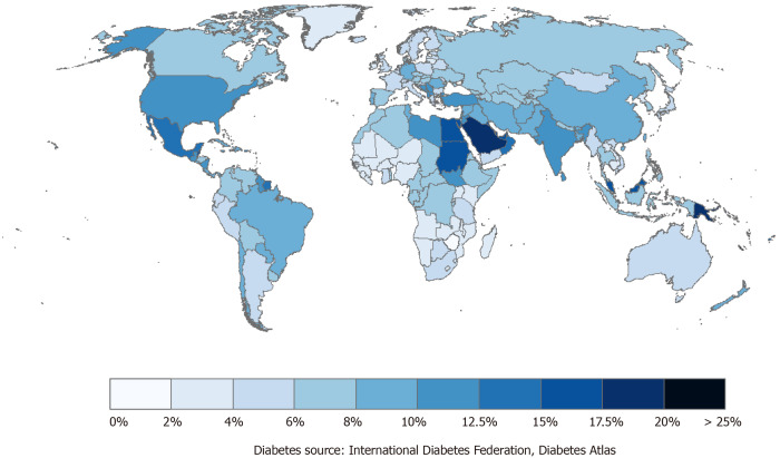
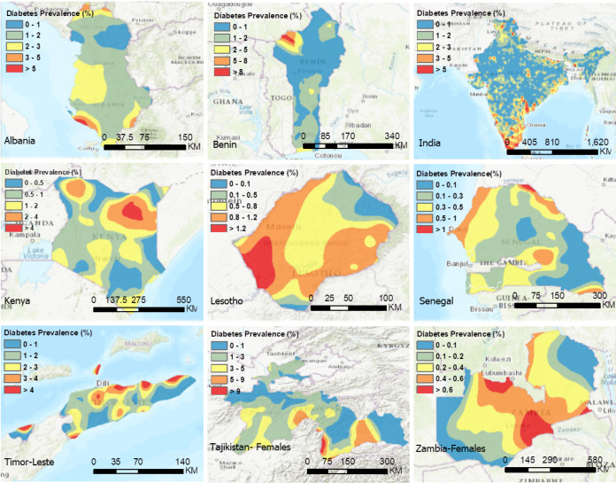
Diabetes mellitus (DM) is a growing epidemic with global proportions. It is estimated that in 2019, 463 million adults aged 20-79 years were living with DM. The latest evidence shows that DM continues to be a significant global health challenge and is likely to continue to grow substantially in the next decades, which would have major implications for healthcare expenditures, particularly in developing countries. Hence, new conceptual and methodological approaches to tackle the epidemic are long overdue. Spatial epidemiology has been a successful approach to control infectious disease epidemics like malaria and human immunodeficiency virus. The implementation of this approach has been expanded to include the study of non-communicable diseases like cancer and cardiovascular diseases. In this review, we discussed the implementation and use of spatial epidemiology and Geographic Information Systems to the study of DM. We reviewed several spatial methods used to understand the spatial structure of the disease and identify the potential geographical drivers of the spatial distribution of DM. Finally, we discussed the use of spatial epidemiology on the design and implementation of geographically targeted prevention and treatment interventions against DM.
Keywords: Diabetes mellitus; Disease mapping; Risk factors; Spatial epidemiology; Spatial statistics.
©The Author(s) 2021. Published by Baishideng Publishing Group Inc. All rights reserved.
Conflict of interest statement
Conflict-of-interest statement: No conflict of interest to report.
Figures
References
-
- Gabbay KH. Hyperglycemia, polyol metabolism, and complications of diabetes mellitus. Annu Rev Med . 1975;26:521–536. - PubMed
-
- Eizirik DL, Pasquali L, Cnop M. Pancreatic β-cells in type 1 and type 2 diabetes mellitus: different pathways to failure. Nat Rev Endocrinol . 2020;16:349–362. - PubMed
-
- World Health Organization. Diabetes Fact sheet N°312. Updated January 2015. [cited 1 February 2021]. Available from: http://www.who.int/mediacentre/factsheets/fs312/en/
-
- American Diabetes Association. (2) Classification and diagnosis of diabetes. Diabetes Care . 2015;38 Suppl:S8–S16. - PubMed
Publication types
LinkOut - more resources
Full Text Sources