

Overcoming navigational challenges: A novel approach to the study and assessment of topographical orientation
- PMID: 34346039
- PMCID: PMC8330964
- DOI: 10.3758/s13428-021-01666-7
Overcoming navigational challenges: A novel approach to the study and assessment of topographical orientation
Abstract
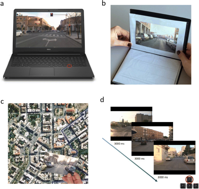
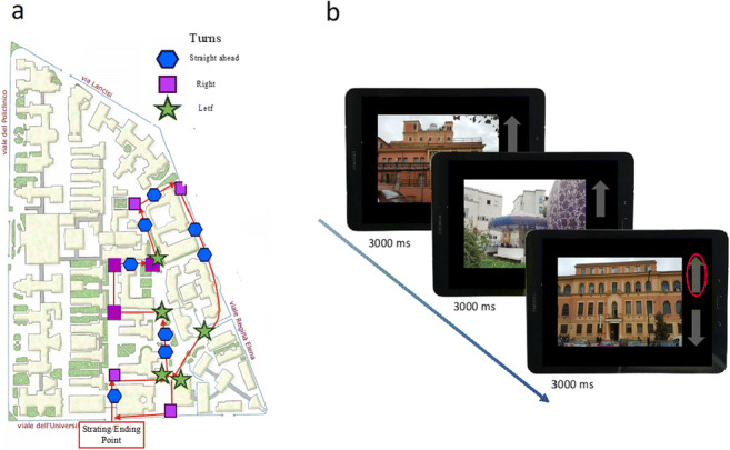
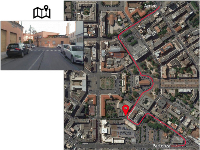
Several studies investigating environmental navigation require participants to navigate in virtual environments, in which the proprioceptive and vestibular components present during real environmental navigation are lost. Here, we aimed to provide a novel computerized ecological navigational battery, investigating whether the absence of proprioceptive and vestibular inputs yields a representation of the navigational space comparable to that acquired ecologically. In Study 1, 38 participants underwent two sets of tasks, one performed in a laboratory-based setting (LBS) and the other in an ecological environment (EE), with both including evaluation of route, landmark, and survey knowledge and a landmark ordering task. All tasks, except the route task, significantly correlated between EE and LBS. In LBS, performance in the landmark ordering task was predicted by that in the survey task, but not by those in the route and landmark tasks. Results of Study 1 were replicated in Study 2, in which 44 participants completed a modified and shorter online version of LBS tests. Reliability of the online LBS tests was also tested and showed a moderate-to-high internal consistency. Overall, results show that the conditions in which tasks are performed affect the acquisition of route knowledge, likely due to the lack of proprioceptive and vestibular information in LBS. However, LBS tasks presented here provide a standard battery of tests that can overcome the replicability problems encountered by ecological navigation tests, while taking into consideration all the complexities of navigational processes in terms of the use of landmark, route, and survey strategies.
Keywords: Allocentric; Egocentric; Spatial navigation; Topographical orientation.
© 2021. The Author(s).
Conflict of interest statement
The authors have no conflicts of interest to declare that are relevant to the content of this article.
Figures
Similar articles
-
Dual Assessment of Developmental Topographical Disorientation: Comparing Self-Reported Measures with Actual Navigational Performance.Brain Sci. 2025 Mar 18;15(3):318. doi: 10.3390/brainsci15030318. Brain Sci. 2025. PMID: 40149839 Free PMC article.
-
Temporal features of spatial knowledge: Representing order and duration of topographical information.Behav Brain Res. 2019 Dec 30;376:112218. doi: 10.1016/j.bbr.2019.112218. Epub 2019 Sep 6. Behav Brain Res. 2019. PMID: 31499091
-
Does spatial cognitive style affect how navigational strategy is planned?Exp Brain Res. 2019 Oct;237(10):2523-2533. doi: 10.1007/s00221-019-05609-9. Epub 2019 Jul 22. Exp Brain Res. 2019. PMID: 31332472
-
Representation of human spatial navigation responding to input spatial information and output navigational strategies: An ALE meta-analysis.Neurosci Biobehav Rev. 2019 Aug;103:60-72. doi: 10.1016/j.neubiorev.2019.06.012. Epub 2019 Jun 12. Neurosci Biobehav Rev. 2019. PMID: 31201830 Review.
-
Topographical disorientation in aging. Familiarity with the environment does matter.Neurol Sci. 2018 Sep;39(9):1519-1528. doi: 10.1007/s10072-018-3464-5. Epub 2018 Jun 12. Neurol Sci. 2018. PMID: 29948464 Review.
Cited by
-
Does path integration contribute to human navigation in large-scale space?Psychon Bull Rev. 2023 Jun;30(3):822-842. doi: 10.3758/s13423-022-02216-8. Epub 2022 Nov 18. Psychon Bull Rev. 2023. PMID: 36401122 Review.
-
Dual Assessment of Developmental Topographical Disorientation: Comparing Self-Reported Measures with Actual Navigational Performance.Brain Sci. 2025 Mar 18;15(3):318. doi: 10.3390/brainsci15030318. Brain Sci. 2025. PMID: 40149839 Free PMC article.
-
The Development of Human Navigation in Middle Childhood: A Narrative Review through Methods, Terminology, and Fundamental Stages.Brain Sci. 2022 Aug 18;12(8):1097. doi: 10.3390/brainsci12081097. Brain Sci. 2022. PMID: 36009160 Free PMC article. Review.
References
Publication types
MeSH terms
LinkOut - more resources
Full Text Sources
