

Habitat selection by the Spiny-tailed lizard (Uromastyx aegyptia): A view from spatial analysis
- PMID: 34466079
- PMCID: PMC8381032
- DOI: 10.1016/j.sjbs.2021.05.020
Habitat selection by the Spiny-tailed lizard (Uromastyx aegyptia): A view from spatial analysis
Abstract
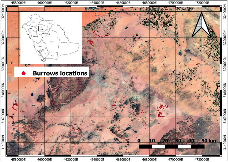
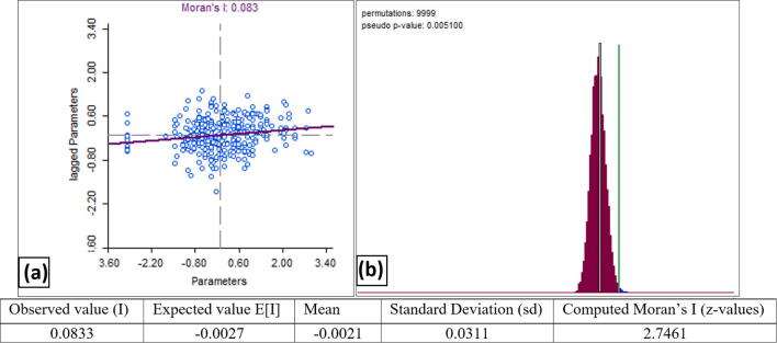
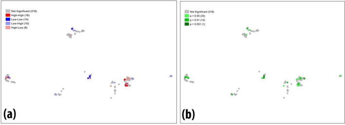
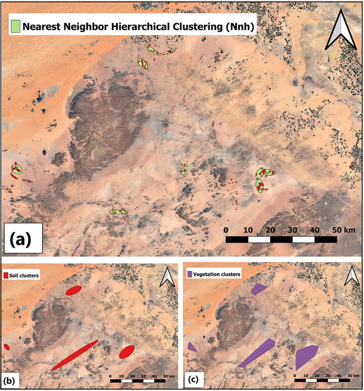
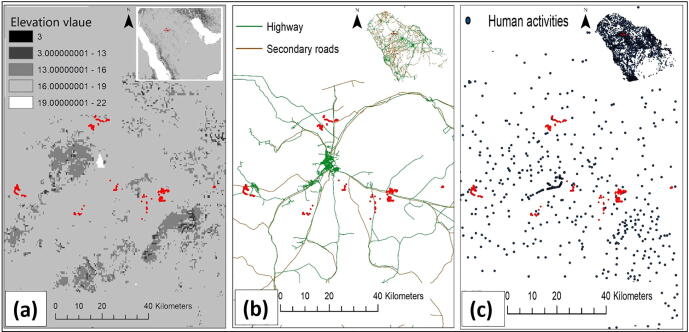
Many factors affect the habitat selection for animal species, which in turn may greatly affect their distribution in different ecosystems. Understanding the processes that affect habitat selection is also critical for guiding and managing conservation initiatives. Our study aimed to assess the habitat selection by free-ranging Spiny-tailed lizard (Uromastyx aegyptia) by analyzing a geospatial data connecting its burrow parameters to different habitat characteristics within selected sites in Hail region, Saudi Arabia. We examined evidence and patterns of significant spatial clustering for (366) active burrows by linking their parameters (burrow entrance size, burrow entrance width and burrow entrance height), their reference geographical locations and, two habitat characteristics defined by soil type and vegetation cover. The objective of the analysis was to increase the understanding on the burrows aggregation process in the space and, to describe its possible relation to other spatial habitat configurations. Analysis of distances based on the Nearest Neighbor Index (NNI) and hotspots detection in Nearest neighbor hierarchical clustering (Nnh) suggested twelve (12) spatial clusters located within the study area. In addition, a spatial ordinary least square (OLS) and Poisson regression models revealed significant effects of soil type and vegetation cover on burrow parameters (OLS, p < 0.05; Poisson, p < 0.001), which indicate a strong association between burrows parameters and habitats characteristics. Findings from the study also suggest that other factors such as elevations, highways, and human settlement concentration spots could possibly play a major role in defining burrow spatial aggregation and furthermore have a significant impact on habitat selection.
Keywords: Burrow parameters; Distance analysis; Hail region; Spatial regression; Uromastyx aegyptia.
© 2021 The Author(s).
Conflict of interest statement
The authors declare that they have no known competing financial interests or personal relationships that could have appeared to influence the work reported in this paper.
Figures
References
-
- Anselin L. Local Indicators of Spatial Association—LISA. Geogr. Analy. 2010;27:93–115. doi: 10.1111/J.1538-4632.1995.TB00338.X. - DOI
-
- Anselin L., Syabri I., Kho Y. GeoDa: An Introduction to Spatial Data Analysis. Geogr. Analy. 2006;38:5–22. doi: 10.1111/J.0016-7363.2005.00671.X. - DOI
-
- Anselin, L., Rey, S., 2014. Modern Spatial Econometrics in Practice: A Guide to GeoDa, GeoDaSpace and PySAL.
-
- Badiane A., Garcia-Porta J., Červenka J., Kratochvíl L., Sindaco R., Robinson M.D., Morales H.E., Mazuch T., Price T., Amat F., Shobrak M., Wilms T.M., Simó-Riudalbas M., Ahmadzadeh F., Papenfuss T., Cluchier A., Viglione J., Carranza S. Phylogenetic relationships of Semaphore geckos (Squamata: Sphaerodactylidae: Pristurus) with an assessment of the taxonomy of Pristurus rupestris. Zootaxa. 2014;3835(1):33–58. doi: 10.11646/zootaxa.3835.1.2. - DOI - PubMed
-
- Bailey, T., Gatrell, A., 1995. Interactive Spatial Data Analysis. https://doi.org/10.2307/2265559.
Further Reading
-
- Dinsmore, S., 2007. Wildlife-habitat Relationships: Concepts and Applications. https://doi.org/10.1650/0010-5422%282007%29109%5B980%3AWRCAA%5D2.0.CO%3B2.
LinkOut - more resources
Full Text Sources
