A Systematic Review of Spatial and Spatio-temporal Analyses in Public Health Research in Korea
- PMID: 34649392
- PMCID: PMC8517372
- DOI: 10.3961/jpmph.21.160
A Systematic Review of Spatial and Spatio-temporal Analyses in Public Health Research in Korea
Abstract
Objectives: Despite its advantages, it is not yet common practice in Korea for researchers to investigate disease associations using spatio-temporal analyses. In this study, we aimed to review health-related epidemiological research using spatio-temporal analyses and to observe methodological trends.
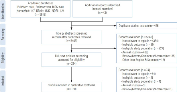
Methods: Health-related studies that applied spatial or spatio-temporal methods were identified using 2 international databases (PubMed and Embase) and 4 Korean academic databases (KoreaMed, NDSL, DBpia, and RISS). Two reviewers extracted data to review the included studies. A search for relevant keywords yielded 5919 studies.
Results: Of the studies that were initially found, 150 were ultimately included based on the eligibility criteria. In terms of the research topic, 5 categories with 11 subcategories were identified: chronic diseases (n=31, 20.7%), infectious diseases (n=27, 18.0%), health-related topics (including service utilization, equity, and behavior) (n=47, 31.3%), mental health (n=15, 10.0%), and cancer (n=7, 4.7%). Compared to the period between 2000 and 2010, more studies published between 2011 and 2020 were found to use 2 or more spatial analysis techniques (35.6% of included studies), and the number of studies on mapping increased 6-fold.
Conclusions: Further spatio-temporal analysis-related studies with point data are needed to provide insights and evidence to support policy decision-making for the prevention and control of infectious and chronic diseases using advances in spatial techniques.
Keywords: Geographic information systems; Public health; Spatial analysis; Spatio-temporal analysis; Systematic review.
Conflict of interest statement
The authors have no conflicts of interest associated with the material presented in this paper.
Figures


References
-
- Meliker JR, Sloan CD. Spatio-temporal epidemiology: principles and opportunities. Spat Spatiotemporal Epidemiol. 2011;2(1):1–9. - PubMed
-
- Pickle LW. A history and critique of U.S. mortality atlases. Spat Spatiotemporal Epidemiol. 2009;1(1):3–17. - PubMed
-
- Nadi S, Delavar MR. Spatio-temporal modeling of dynamic phenomena in GIS. In: ScanGIS 2003: Proceedings 9th Scandinavian Research Conference on Geographical Information Sciences; 2003 Jun 4-6; Espoo, Finland. 2013, p. 215-225.
Publication types
MeSH terms
Grants and funding
LinkOut - more resources
Full Text Sources