

Maplaria: a user friendly web-application for spatio-temporal malaria prevalence mapping
- PMID: 34930265
- PMCID: PMC8686323
- DOI: 10.1186/s12936-021-04011-7
Maplaria: a user friendly web-application for spatio-temporal malaria prevalence mapping
Abstract
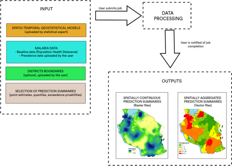
Background: Model-based geostatistical (MBG) methods have been extensively used to map malaria risk using community survey data in low-resource settings where disease registries are incomplete or non-existent. However, the wider adoption of MBG methods by national control programmes to inform health policy decisions is hindered by the lack of advanced statistical expertise and suitable computational equipment. Here, Maplaria, an interactive, user-friendly web-application that allows users to upload their own malaria prevalence data and carry out geostatistical prediction of annual malaria prevalence at any desired spatial scale, is introduced.
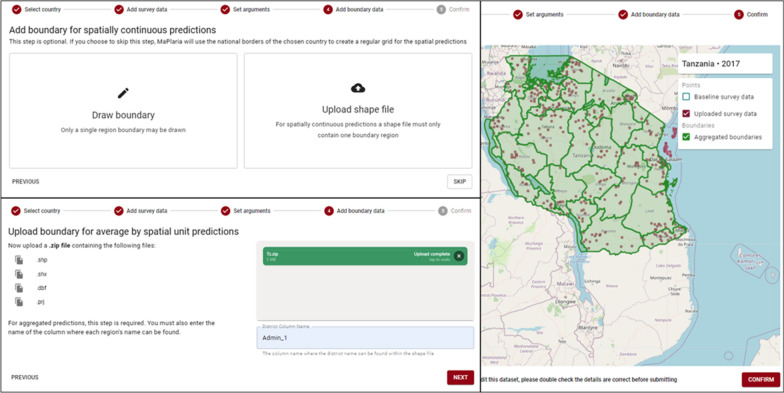
Methods: In the design of the Maplaria web application, two main criteria were considered: the application should be able to classify subnational divisions into the most likely endemicity levels; the web application should allow only minimal input from the user in the set-up of the geostatistical inference process. To achieve this, the process of fitting and validating the geostatistical models is carried out by statistical experts using publicly available malaria survey data from the Harvard database. The stage of geostatistical prediction is entirely user-driven and allows the user to upload malaria data, as well as vector data that define the administrative boundaries for the generation of spatially aggregated inferences.
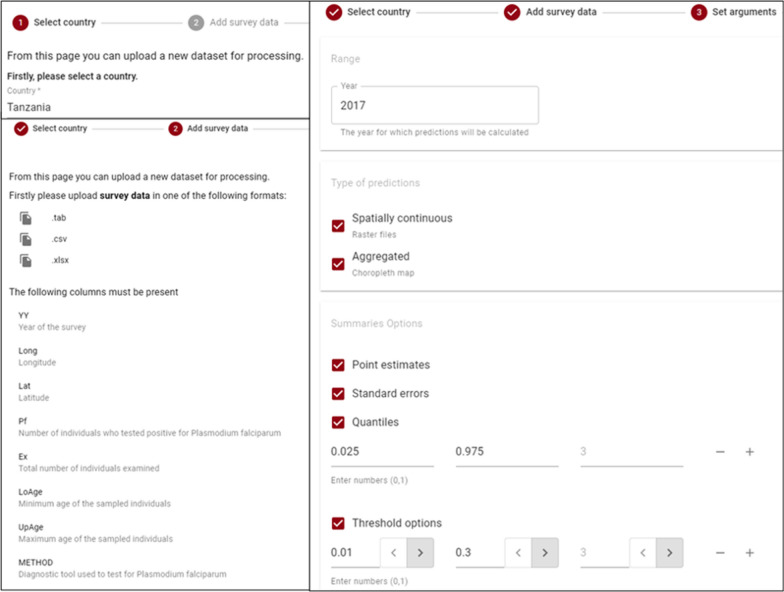
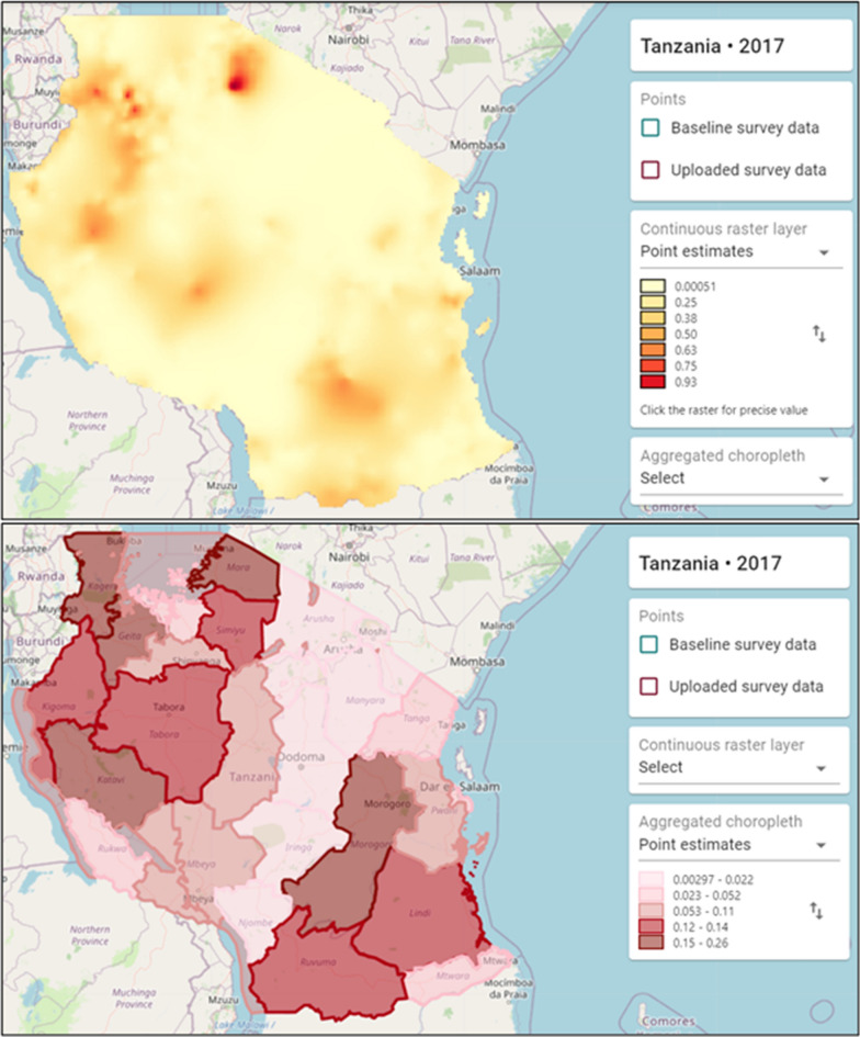
Results: The process of data uploading and processing is split into a series of steps spread across screens through the progressive disclosure technique that prevents the user being immediately overwhelmed by the length of the form. Each of these is illustrated using a data set from the Malaria Indicator carried out in Tanzania in 2017 as an example.
Conclusions: Maplaria application provides a user-friendly solution to the problem making geostatistical methods more accessible to users that have not undertaken formal training in statistics. The application is a useful tool that can be used to foster ownership, among policy makers, of disease risk maps and promote better use of data for decision-making in low resource settings.
Keywords: Cross-sectional surveys; Malaria; Malaria mapping; Model based geostatistics; National malaria control programme; Sub Saharan Africa; Web application.
© 2021. The Author(s).
Conflict of interest statement
The authors declare they have no competing interest.
Figures
Similar articles
-
Effects of vector-control interventions on changes in risk of malaria parasitaemia in sub-Saharan Africa: a spatial and temporal analysis.Lancet Glob Health. 2014 Oct;2(10):e601-15. doi: 10.1016/S2214-109X(14)70300-6. Lancet Glob Health. 2014. PMID: 25304636
-
Spatio-temporal mapping of Madagascar's Malaria Indicator Survey results to assess Plasmodium falciparum endemicity trends between 2011 and 2016.BMC Med. 2018 May 23;16(1):71. doi: 10.1186/s12916-018-1060-4. BMC Med. 2018. PMID: 29788968 Free PMC article.
-
Spatially explicit burden estimates of malaria in Tanzania: bayesian geostatistical modeling of the malaria indicator survey data.PLoS One. 2012;7(5):e23966. doi: 10.1371/journal.pone.0023966. Epub 2012 May 23. PLoS One. 2012. PMID: 22649486 Free PMC article.
-
Spatial and spatio-temporal methods for mapping malaria risk: a systematic review.BMJ Glob Health. 2020 Oct;5(10):e002919. doi: 10.1136/bmjgh-2020-002919. BMJ Glob Health. 2020. PMID: 33023880 Free PMC article.
-
Further shrinking the malaria map: how can geospatial science help to achieve malaria elimination?Lancet Infect Dis. 2013 Aug;13(8):709-18. doi: 10.1016/S1473-3099(13)70140-3. Lancet Infect Dis. 2013. PMID: 23886334 Review.
Cited by
-
Web-based models to inform health policy: A scoping review.Health Res Policy Syst. 2025 Aug 4;23(1):99. doi: 10.1186/s12961-025-01367-z. Health Res Policy Syst. 2025. PMID: 40760496 Free PMC article. Review.
-
Optimizing Routine Malaria Surveillance Data in Urban Environments: A Case Study in Maputo City, Mozambique.Am J Trop Med Hyg. 2022 Oct 3;108(2_Suppl):24-31. doi: 10.4269/ajtmh.22-0166. Print 2023 Feb 2. Am J Trop Med Hyg. 2022. PMID: 36191871 Free PMC article.
References
-
- WHO. World malaria report 2020. Geneva: World Health Organization; 2020. https://www.who.int/publications/i/item/9789240015791. Accessed 20 May 2021
-
- WHO. Global technical strategy for malaria 2016–2030. Geneva: World Health Organization; 2015. https://www.who.int/docs/default-source/documents/global-technical-strat.... Accessed 20 May 2021.
MeSH terms
Grants and funding
LinkOut - more resources
Full Text Sources
Medical
