. 2022 Jan 17;12(1):796.
doi: 10.1038/s41598-022-04766-2.

Diagnosing challenges and setting priorities for sustainable water resource management under climate change

Affiliations

Diagnosing challenges and setting priorities for sustainable water resource management under climate change

Ibrahim Nourein Mohammed et al. Sci Rep. .

Abstract

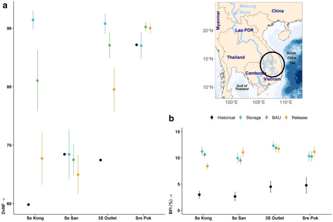
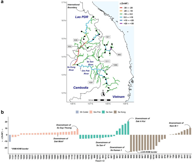
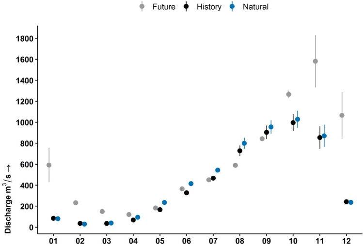
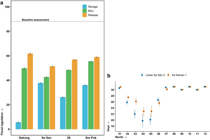
Managing transboundary river basins requires balancing tradeoffs of sustainable water use and coping with climate uncertainty. We demonstrate an integrated approach to exploring these issues through the lens of a social-ecological system, combining remote and in-situ earth observations, hydrologic and climate models, and social surveys. Specifically, we examine how climate change and dam development could impact the Se Kong, Se San and Sre Pok rivers in the Mekong region. We find that climate change will lead to increased precipitation, necessitating a shift in dam operations, from maintaining low flows to reducing flood hazards. We also find that existing water governance systems in Laos, Vietnam, and Cambodia are ill-prepared to address the problem. We conclude that the solution space for addressing these complex issues will be highly constrained unless major deficiencies in transboundary water governance, strategic planning, financial capacity, information sharing, and law enforcement are remedied in the next decades.


Conflict of interest statement

The authors declare no competing interests.

Figures

Figure 1
Figure 1
Se Kong, Se San and Sre Pok (3S) River Basin flow regime under 24 climate change and management scenarios (a) mean (± 95% CI) deviation from natural flow (DvNF) (b) mean (± 95% CI) base flow index (BFI). Historical results calculated from the 2002—2018 time period, climate and management scenarios calculated from 2025—2050 time period. Map created and drafted using R: A language and environment for statistical computing version 4.0.3: https://www.R-project.org/ (Vienna, Austria). The map layout was plotted using EPSG Geodetic Parameter Dataset 4326 projection (https://epsg.io/4326).
Figure 2
Figure 2
Change in deviation from natural flow (ΔDvNF=DvNFStorage-DvNFRelease) within the Se Kong, Se San, and Sre Pok (3S) River Basin under the Coupled Model Intercomparison Project Phase 5 (CMIP5) representative concentration scenario (RCP 8.5) with the GFDL—CM3 climate group in response to different management scenarios, (a) spatial variation of the change in deviation from natural flow, and (b) bar plot of the change in deviation from natural flow. Black dots are modelled existing and planned reservoirs. A zero in ΔDvNF refers to 3S River segments that are insensitive to management scenarios. The DvNF results shown were calculated from 2025 to 2050 time period. The 3S River segments are labeled with Reach ID numbers (e.g., Reach ID # 1022 is the 3S Outlet). Map created and drafted using R: A language and environment for statistical computing version 4.0.3: https://www.R-project.org/ (Vienna, Austria). The map layout was plotted using EPSG Geodetic Parameter Dataset 4326 projection (https://epsg.io/4326).
Figure 3
Figure 3
Yali Reservoir downstream flow hydrograph of mean (± 95% confidence interval) discharge under natural, historical, and future (Business as Usual reservoir rules) scenarios. Natural and historic discharge derived from 2002 to 2016. Future flows were calculated from four climate model groups and two greenhouse gas emissions scenarios under the Coupled Model Intercomparison Project Phase 5 (CMIP5) from 2025 to 2050.
Figure 4
Figure 4
Se Kong, Se San and Sre Pok (3S) River Basin flood regime under 24 climate change and management scenarios from 2025 to 2050 (a) mean (± 95% CI) flood regulation (how many and how often reservoirs reach a flood storage threshold) capacity for the three management scenarios on a scale of 0 (low) to 100 (high) for each tributary and the whole 3S Basin. Baseline assessment from Souter et al.. (b) Mean (± 95% CI) number of days with storage equal to or greater than 95% of the maximum reservoir storage volume at the Lower Se San 2 and Xe Kaman 1 dams for the Business as Usual management rules.
Figure 5
Figure 5
Governance and Stakeholders survey responses for (a) Strategic planning and adaptive management (a, shared vision; b, strategic planning mechanisms; and c, adaptive management framework.); and (b) Water Resource Management (a, coordinated policies and actions; b centrally managed infrastructure; c financial resources; and d ecosystems conservation priorities). Full descriptions of each survey response and scale categories are provided in the Supplementary Information. Response country codes are: INTL (International), KHM (Cambodia), LAO (Laos, PDR), and VNM (Vietnam).

References

    1. De Stefano L, Petersen-Perlman JD, Sproles EA, Eynard J, Wolf AT. Assessment of transboundary river basins for potential hydro-political tensions. Global Environ. Chang. 2017;45:35–46.
    1. Reed PM, Kasprzyk J. Water resources management: The myth, the wicked, and the future. J. Water Res. Plan. Man. 2009;135:411–413.
    1. Reddy VR, Syme GJ. Social sciences and hydrology: An introduction. J. Hydrol. 2014;518:1–4.
    1. Grafton RQ, et al. Global insights into water resources, climate change and governance. Nat. Clim. Change. 2013;3:315–321.
    1. UNESCO & UN-Water. United Nations World Water Development Report 2020: Water and Climate Change. Paris, France: UNESCO; 2020. Report No.: ISBN: 978-92-3-100371-4.

Publication types