. 2022 Mar 25;12(1):5178.
doi: 10.1038/s41598-022-09049-4.

Comparison of weather station and climate reanalysis data for modelling temperature-related mortality

Collaborators, Affiliations

Comparison of weather station and climate reanalysis data for modelling temperature-related mortality

Malcolm N Mistry et al. Sci Rep. .

Erratum in

  • Author Correction: Comparison of weather station and climate reanalysis data for modelling temperature-related mortality.
    Mistry MN, Schneider R, Masselot P, Royé D, Armstrong B, Kyselý J, Orru H, Sera F, Tong S, Lavigne É, Urban A, Madureira J, García-León D, Ibarreta D, Ciscar JC, Feyen L, de Schrijver E, de Sousa Zanotti Stagliorio Coelho M, Pascal M, Tobias A; Multi-Country Multi-City (MCC) Collaborative Research Network; Guo Y, Vicedo-Cabrera AM, Gasparrini A. Mistry MN, et al. Sci Rep. 2022 May 13;12(1):7960. doi: 10.1038/s41598-022-11769-6. Sci Rep. 2022. PMID: 35562397 Free PMC article. No abstract available.

Abstract

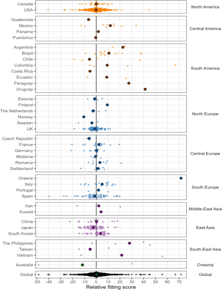
Epidemiological analyses of health risks associated with non-optimal temperature are traditionally based on ground observations from weather stations that offer limited spatial and temporal coverage. Climate reanalysis represents an alternative option that provide complete spatio-temporal exposure coverage, and yet are to be systematically explored for their suitability in assessing temperature-related health risks at a global scale. Here we provide the first comprehensive analysis over multiple regions to assess the suitability of the most recent generation of reanalysis datasets for health impact assessments and evaluate their comparative performance against traditional station-based data. Our findings show that reanalysis temperature from the last ERA5 products generally compare well to station observations, with similar non-optimal temperature-related risk estimates. However, the analysis offers some indication of lower performance in tropical regions, with a likely underestimation of heat-related excess mortality. Reanalysis data represent a valid alternative source of exposure variables in epidemiological analyses of temperature-related risk.


Conflict of interest statement

The authors declare no competing interests.

Figures

Figure 1
Figure 1
A schematic outline of the comparative analysis framework used in this study.
Figure 2
Figure 2
Correlation between MCC weather station and ERA5-Land daily mean temperature (°C) across the 612 locations used in the study.
Figure 3
Figure 3
Overall cumulative exposure–response associations in selective cities representative of the 39 countries (station observations—black and ERA5-Land—red, with 95% confidence intervals (CI)—shaded, see “Methods”). Exposure–response associations as best linear unbiased prediction (BLUP, see “Methods”) using the distribution drawn from station temperature. Dashed vertical grey lines are the minimum mortality temperatures (MMTs). RR relative risk.
Figure 4
Figure 4
Scatterplots of: (a) and (b) cumulative relative risks (RRs) at the 1st and the 99th percentile respectively; (c) Minimum mortality temperature (MMT) and (d) Minimum mortality percentile (MMP). The RRs, MMP and MMT are based on the respective station and ERA5-Land temperatures of the best linear unbiased predictions (BLUPs) for individual cities. Blue lines and the r values represent the linear regression trend and the Pearson correlation coefficient of compared variables, respectively. The dashed black line represents the 1:1 line.
Figure 5
Figure 5
Fraction of all-cause excess mortality (%) due to cold and heat by countries and all 612 locations (Global) estimated using station observations (gray) and ERA5-Land (red). The bar plots represent the excess deaths. The 95% empirical confidence intervals (eCI) computed using Monte Carlo simulations (see “Methods”) are reported in Table S3 in the “Supplementary material”. The range of x-axes are different in the two panels.
Figure 6
Figure 6
Relative fitting score (RFS) for station observations and ERA5-Land by country. A negative score indicates a better performance of the model based on ERA5-Land temperature relative to the model fitted using station temperature at a location. The shaded circle in each country panel depicts the median RFS. ‘Global’ implies all 612 locations used in the study.

References

    1. Colston JM, et al. Evaluating meteorological data from weather stations, and from satellites and global models for a multi-site epidemiological study. Environ. Res. 2018;165:91–109. - PMC - PubMed
    1. Auffhammer M, Hsiang SM, Schlenker W, Sobel A. Using weather data and climate model output in economic analyses of climate change. Rev. Environ. Econ. Policy. 2013;7:181–198.
    1. Weinberger KR, Spangler KR, Zanobetti A, Schwartz JD, Wellenius GA. Comparison of temperature-mortality associations estimated with different exposure metrics. Environ. Epidemiol. 2019;3:e072. - PMC - PubMed
    1. Lee M, Shi L, Zanobetti A, Schwartz JD. Study on the association between ambient temperature and mortality using spatially resolved exposure data. Environ. Res. 2016;151:610–617. - PMC - PubMed
    1. Lemonsu A, Viguié V, Daniel M, Masson V. Vulnerability to heat waves: Impact of urban expansion scenarios on urban heat island and heat stress in Paris (France) Urban Clim. 2015;14:586–605.

Publication types