

Autonomous Navigation System of Greenhouse Mobile Robot Based on 3D Lidar and 2D Lidar SLAM
- PMID: 35360319
- PMCID: PMC8960995
- DOI: 10.3389/fpls.2022.815218
Autonomous Navigation System of Greenhouse Mobile Robot Based on 3D Lidar and 2D Lidar SLAM
Abstract
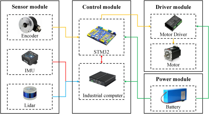
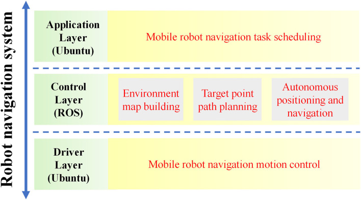
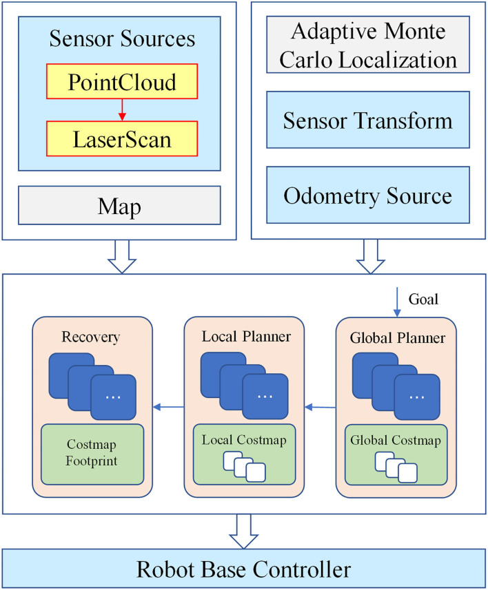
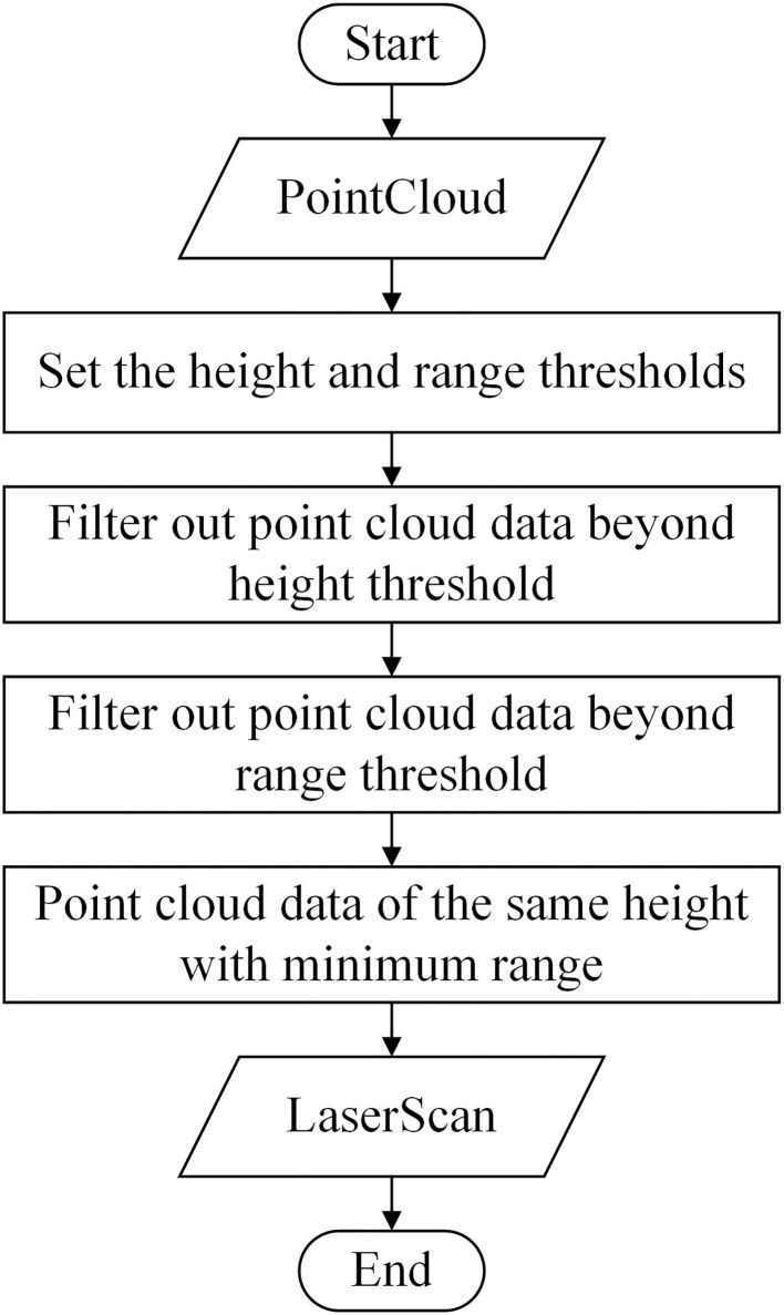
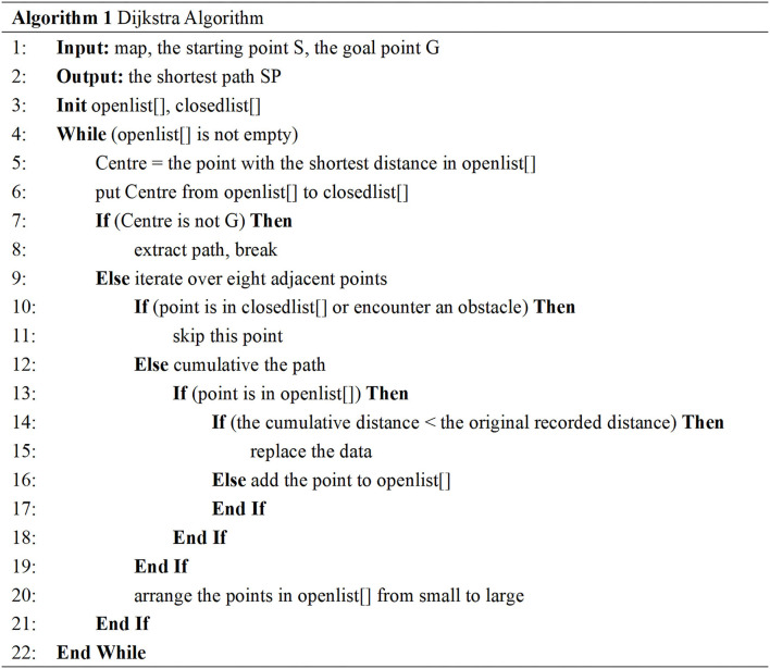
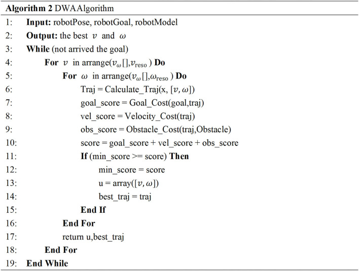
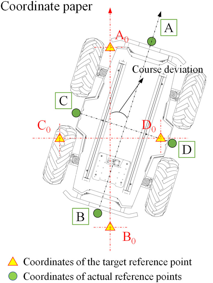
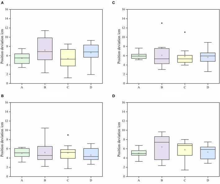
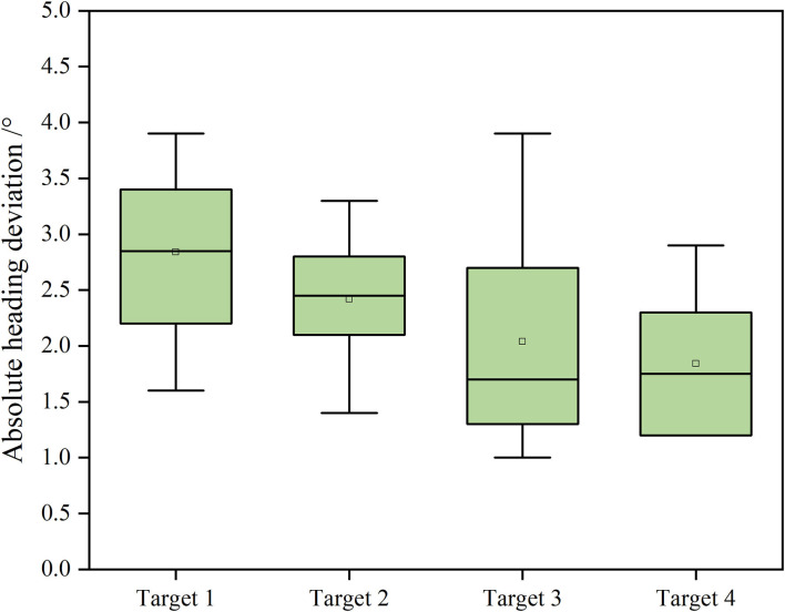
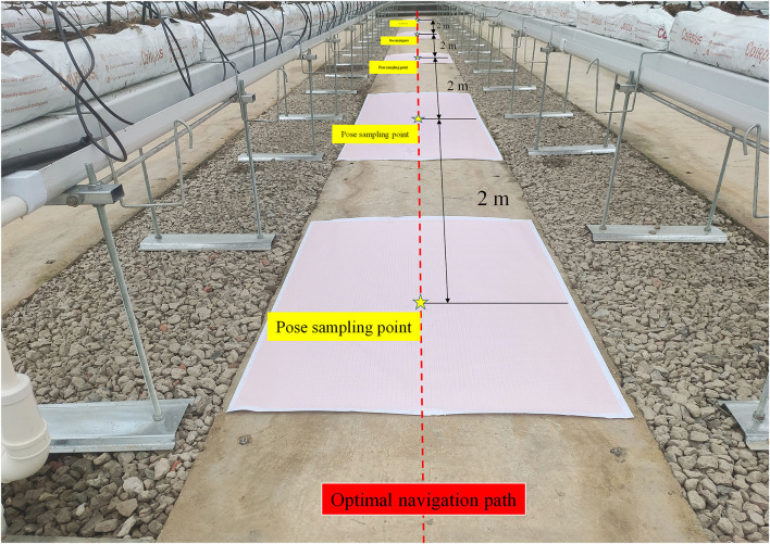
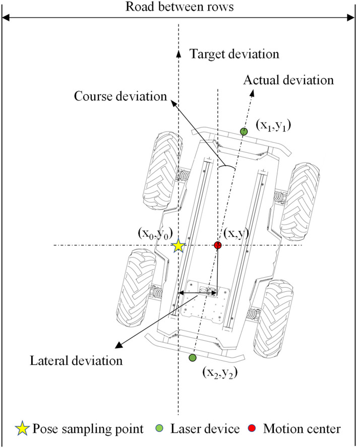
The application of mobile robots is an important link in the development of intelligent greenhouses. In view of the complex environment of a greenhouse, achieving precise positioning and navigation by robots has become the primary problem to be solved. Simultaneous localization and mapping (SLAM) technology is a hot spot in solving the positioning and navigation in an unknown indoor environment in recent years. Among them, the SLAM based on a two-dimensional (2D) Lidar can only collect the environmental information at the level of Lidar, while the SLAM based on a 3D Lidar demands a high computation cost; hence, it has higher requirements for the industrial computers. In this study, the robot navigation control system initially filtered the information of a 3D greenhouse environment collected by a 3D Lidar and fused the information into 2D information, and then, based on the robot odometers and inertial measurement unit information, the system has achieved a timely positioning and construction of the greenhouse environment by a robot using a 2D Lidar SLAM algorithm in Cartographer. This method not only ensures the accuracy of a greenhouse environmental map but also reduces the performance requirements on the industrial computer. In terms of path planning, the Dijkstra algorithm was used to plan the global navigation path of the robot while the Dynamic Window Approach (DWA) algorithm was used to plan the local navigation path of the robot. Through the positioning test, the average position deviation of the robot from the target positioning point is less than 8 cm with a standard deviation (SD) of less than 3 cm; the average course deviation is less than 3° with an SD of less than 1° at the moving speed of 0.4 m/s. The robot moves at the speed of 0.2, 0.4, and 0.6 m/s, respectively; the average lateral deviation between the actual movement path and the target movement path is less than 10 cm, and the SD is less than 6 cm; the average course deviation is <3°, and the SD is <1.5°. Both the positioning accuracy and the navigation accuracy of the robot can meet the requirements of mobile navigation and positioning in the greenhouse environment.
Keywords: Lidar; SLAM; greenhouse; mobile robot; navigation.
Copyright © 2022 Jiang, Wang, Yi, Zhang and Lv.
Conflict of interest statement
The authors declare that the research was conducted in the absence of any commercial or financial relationships that could be construed as a potential conflict of interest.
Figures
References
-
- Arad B., Balendonck J., Barth R., Ben-Shahar O., Edan O., Hellström T., et al. (2020). Development of a sweet pepper harvesting robot. J. Field Robot. 37, 1027–1039. 10.1002/rob.21937 - DOI
-
- Balaso S. D., Arima S., Ueka Y., Kono M., Takahashi N. (2013). Development of a multi-operation system for intelligent greenhouses. IFAC Proceed. Volum. 46, 287–292. 10.3182/20130327-3-JP-3017.00066 - DOI
-
- Chan E., Baciu G., Mak S. C. (2009). Using Wi-Fi signal strength to localize in wireless sensor networks. 2009 wri international conference on communications and mobile computing. IEEE 1, 538–42. 10.1109/CMC.2009.233 - DOI
-
- Chen J., Qiang H., Wu J., Xu G., Wang Z. (2021). Navigation path extraction for greenhouse cucumber-picking robots using the prediction-point Hough transform. Comput. Electron. Agr. 180, 105911. 10.1016/j.compag.2020.105911 - DOI
-
- Chiu Y. C., Chen S., Lin J. F. (2013). Study of an autonomous fruit picking robot system in greenhouses. Eng. Agric. Environ. Food. 6, 92–98. 10.1016/S1881-8366(13)80017-1 - DOI
LinkOut - more resources
Full Text Sources