

Mapping the "catscape" formed by a population of pet cats with outdoor access
- PMID: 35396515
- PMCID: PMC8993881
- DOI: 10.1038/s41598-022-09694-9
Mapping the "catscape" formed by a population of pet cats with outdoor access
Abstract
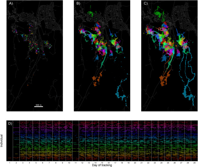
The domestic cat (Felis catus) is among the most popular companion animals and most abundant carnivores globally. It is also a pet with an immense ecological footprint because even non-feral and food-subsidized cats can be prolific predators. Whereas knowledge about the spatial behavior of individual domestic cats is growing, we still know little about how a local population of free-ranging pet cats occupies the landscape. Using a citizen science approach, we GPS-tagged 92 pet cats with outdoor access living in a residential area in southern Norway. The resulting position data allowed us to construct both individual home range kernels and a population-level utilization distribution. Our results reveal a dense predatory blanket that outdoor cats drape over and beyond the urban landscape. It is this population-level intensity surface-the "catscape"-that potential prey have to navigate. There were few gaps in the catscape within our residential study area and therefore few terrestrial refuges from potential cat predation. However, cats spent on average 79% of their outdoor time within 50 m to their owner's home, which suggests that the primary impact is local and most acute for wildlife in the vicinity to homes with cats. We discuss the catscape as a conceptual and quantitative tool for better understanding and mitigating the environmental impact of domestic cats.
© 2022. The Author(s).
Conflict of interest statement
The authors declare no competing interests.
Figures


References
-
- Seymour, C. L. et al. Caught on camera: The impacts of urban domestic cats on wild prey in an African city and neighbouring protected areas. Glob. Ecol. Conserv.23, e01198 (2020).
-
- Mori, E. et al. License to Kill? Domestic Cats Affect a Wide Range of Native Fauna in a Highly Biodiverse Mediterranean Country. Front. Ecol. Evol.7, 477 (2019).
-
- Kays, R. et al. The small home ranges and large local ecological impacts of pet cats. Anim. Conserv.23, 516–523 (2020).
-
- Loss, S. R., Will, T. & Marra, P. P. The impact of free-ranging domestic cats on wildlife of the United States. Nat. Commun.4, 1396 (2013). - PubMed
-
- Van Heezik, Y., Smyth, A., Adams, A. & Gordon, J. Do domestic cats impose an unsustain386 able harvest on urban bird populations?. Biol. Conserv.143, 121–130 (2010).
Publication types
MeSH terms
LinkOut - more resources
Full Text Sources
Miscellaneous
