Review
. 2022;218(3):14.
doi: 10.1007/s11214-022-00882-7. Epub 2022 Apr 5.

Mission Overview and Scientific Contributions from the Mars Science Laboratory Curiosity Rover After Eight Years of Surface Operations

Affiliations
Review

Mission Overview and Scientific Contributions from the Mars Science Laboratory Curiosity Rover After Eight Years of Surface Operations

Ashwin R Vasavada. Space Sci Rev. 2022.

Abstract

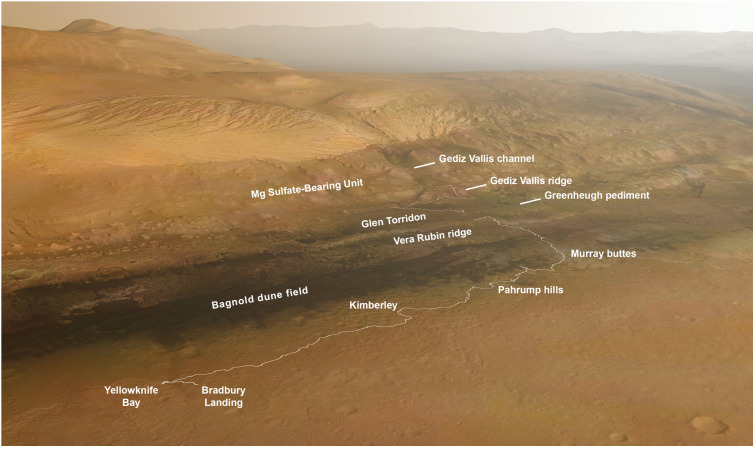
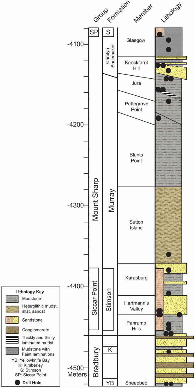
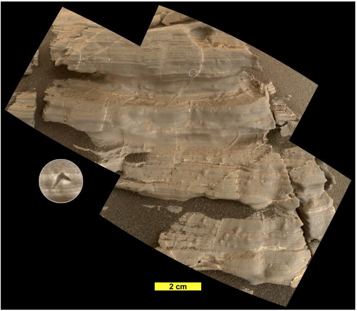
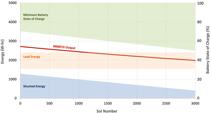
NASA's Mars Science Laboratory mission, with its Curiosity rover, has been exploring Gale crater (5.4° S, 137.8° E) since 2012 with the goal of assessing the potential of Mars to support life. The mission has compiled compelling evidence that the crater basin accumulated sediment transported by marginal rivers into lakes that likely persisted for millions of years approximately 3.6 Ga ago in the early Hesperian. Geochemical and mineralogical assessments indicate that environmental conditions within this timeframe would have been suitable for sustaining life, if it ever were present. Fluids simultaneously circulated in the subsurface and likely existed through the dry phases of lake bed exposure and aeolian deposition, conceivably creating a continuously habitable subsurface environment that persisted to less than 3 Ga in the early Amazonian. A diversity of organic molecules has been preserved, though degraded, with evidence for more complex precursors. Solid samples show highly variable isotopic abundances of sulfur, chlorine, and carbon. In situ studies of modern wind-driven sediment transport and multiple large and active aeolian deposits have led to advances in understanding bedform development and the initiation of saltation. Investigation of the modern atmosphere and environment has improved constraints on the timing and magnitude of atmospheric loss, revealed the presence of methane and the crater's influence on local meteorology, and provided measurements of high-energy radiation at Mars' surface in preparation for future crewed missions. Rover systems and science instruments remain capable of addressing all key scientific objectives. Emphases on advance planning, flexibility, operations support work, and team culture have allowed the mission team to maintain a high level of productivity in spite of declining rover power and funding.

Supplementary information: The online version contains supplementary material available at 10.1007/s11214-022-00882-7.

Keywords: Astrobiology; Climate; Geology; Mars; Meteorology; Planets.


Conflict of interest statement

Conflicts of interest/Competing interestsThe author has no relevant financial or non-financial interests to disclose.

Figures

Fig. 1
Fig. 1
South-facing oblique view of Curiosity’s traverse annotated with geographic markers and morphological/mineralogical units as defined from orbiter data. The Vera Rubin ridge and Glen Torridon are coincident with the orbital hematite-bearing and clay-bearing units, respectively. Curiosity landed on the plains surrounding Mount Sharp and crossed onto the mountain at Pahrump hills. After initially traveling southwest to Murray buttes to reach a point where the Bagnold dunes could be safely crossed, the rover headed southeast and more directly uphill. The future strategic route is shown beyond Glen Torridon, where the rover is at Sol 2844 (background image credit: Seán Doran)
Fig. 2
Fig. 2
Cumulative stratigraphic column showing the vertical ordering of lithologic units encountered along Curiosity’s traverse. This two-dimensional representation was compiled from rover observations as it traversed both vertically and laterally. The width of segments in the lithology column indicates apparent resistance to erosion
Fig. 3
Fig. 3
Mastcam mosaic of finely laminated mudstone near the Telegraph Peak drill site, Pahrump Hills, acquired on Sol 837 (MR003676, image credit: NASA/JPL-Caltech/MSSS)
Fig. 4
Fig. 4
Rendering from the OnSight visualization tool developed by JPL and Microsoft based on the orbiter-derived digital elevation model and rover images and telemetry from Sols 2476-2477. The rover was parked at a near-record 25° tilt in order to acquire remote and contact science observations of bedrock exposed along a ridge in Glen Torridon
Fig. 5
Fig. 5
Example of diagenetic overprinting. This MAHLI mosaic from the “Jura” target on Sol 1925 shows a highly eroded fragment of finely laminated mudstone of the Jura member on Vera Rubin ridge. Fractures are filled with calcium sulfate veins. Millimeter-scale crystal forms have lenticular, “swallow tail,” and star forms that are characteristic of gypsum crystals. The inset (3 mm in diameter) is an example of the swallow-tail shape. Neither the veins nor crystal forms deform primary laminations and therefore are interpreted to have occurred post-lithification (image credit: NASA/JPL-Caltech/MSSS)
Fig. 6
Fig. 6
Mastcam mosaic of the basal Siccar Point group unconformity acquired on Sol 2685 showing crossbedding in the Greenheugh pediment capping unit and the nodular texture just above the contact with the underlying Mount Sharp group (MR014053, image credit: NASA/JPL-Caltech/MSSS)
Fig. 7
Fig. 7
Curiosity at the Gobabeb site on Namib dune on Sol 1228. The MAHLI mosaic shows the primary (meter-scale) and secondary (cm-scale) ripples on the dune as well as an arcuate trench intentionally created using the rover’s wheel (image credit: NASA/JPL-Caltech/MSSS)
Fig. 8
Fig. 8
Schematic of rover energy utilization as a function of mission sol. The red line shows the declining MMRTG energy output per sol. The energy used for rover activities (load energy) is typically within the orange region, leaving excess energy to be shunted to the environment as shown by the blue region. The lowest battery state of charge reached each sol falls within the green area. The chart shows that the energy used for rover activities has remained relatively constant. However, as the energy supply and battery capacity have decreased over time, rover activities have discharged the battery to lower levels and left less excess energy. Soon the diminished energy supply and battery capacity will require reductions in energy use and additional time dedicated to battery charging
Fig. 9
Fig. 9
Gallery of MAHLI images of the 27 holes successful drilled (see Table 3 for details) through Sol 2844 (image credit: NASA/JPL-Caltech/MSSS). The diameter of each drill hole is ∼16 mm. In most cases the surface is coated by typical martian dust and the color of the drill tailings reveals the different composition and spectral properties of the rock interior
Fig. 10
Fig. 10
Sol 2068 Mastcam image showing the rover’s drill bit positioned over the closed inlet to the CheMin instrument. After the loss of the drill’s feed motor, sample material must be delivered directly from the drill to the CheMin and SAM instrument inlets. Prior to the loss, sample material was processed and delivered by a dedicated tool (ML010980, image credit: NASA/JPL-Caltech/MSSS)
Fig. 11
Fig. 11
Schematic and descriptions of science operations planning tiers. MSL science operations involve planning over three time domains: Strategic (10s to 100s of sols), Look-Ahead (2-10 sols after the current uplink), and Tactical (next uplink, referred to as the “Sol N” plan). The steps shown in the Tactical row occur over a single shift in the order shown. Hashed areas are time periods that are not the primary focus of the planning tier but provide initial conditions or future constraints
Fig. 12
Fig. 12
Summary chart of mission performance showing cumulative drive distance (solid line) and elevation (dotted line) as a function of sol and mission phase. After a sprint to reach Mount Sharp in the latter half of the 26-month Prime Mission, the pace of driving (a proxy for total rover activity) remained relatively constant in EM1 (two years) and much of EM2 (three years). The pace subsequently has slightly slowed, with the exception of a sprint near the end of the period shown. The elevation trend shows the descent into Yellowknife Bay in the early Prime Mission, the direct climb up Mount Sharp to the Vera Rubin ridge from mid-EM1 to mid-EM2, and the more gradual ascent through the Glen Torridon region. Orange triangles and blue dots mark the timings of successful scooping and drilling campaigns, respectively

References

    1. Abbey W., Anderson R., Beegle L., Hurowitz J., Williford K., Peters G., Morookian J.M., Collins C., Feldman J., Kinnett R., Jandura L., Limonadi D., Logan C., McCloskey S., Melko J., Okon A., Robinson M., Roumeliotis C., Seybold C., Singer J., Warner N. A look back: the drilling campaign of the Curiosity rover during the Mars Science Laboratory’s Prime Mission. Icarus. 2019;319:1–13. doi: 10.1016/j.icarus.2018.09.004. - DOI
    1. Abbey W., Anderson R., Beegle L.W., Peters G., Morookian J.M., Biesiadecki J., Carsten J., Collins C., Davis K., Kinnett R., Klein D., Kuhn S., Logan C., Maimone M., Melko J., Okon A., Reid J., Robinson M., Singer J., Verma V., Vasavada A.R. A look back, part II: the drilling campaign of the Curiosity rover during the Mars Science Laboratory’s second and third Martian years. Icarus. 2020;350:113885. doi: 10.1016/j.icarus.2020.113885. - DOI
    1. Achilles C.N., Downs R.T., Ming D.W., Rampe E.B., Morris R.V., Treiman A.H., Morrison S.M., Blake D.F., Vaniman D.T., Ewing R.C., Chipera S.J., Yen A.S., Bristow T.F., Ehlmann B.L., Gellert R., Hazen R.M., Fendrich K.V., Craig P.I., Grotzinger J.P., Des Marais D.J., Farmer J.D., Sarrazin P.C., Morookian J.M. Mineralogy of an active eolian sediment from the Namib dune, Gale crater, Mars. J. Geophys. Res., Planets. 2017;122:2344–2361. doi: 10.1002/2017JE005262. - DOI
    1. Achilles C.N., Rampe E.B., Downs R.T., Bristow T.F., Ming D.W., Morris R.V., Vaniman D.T., Blake D.F., Yen A.S., McAdam A.C., Sutter B., Fedo C.M., Gwizd S., Thompson L.M., Gellert R., Morrison S.M., Treiman A.H., Crisp J.A., Gabriel T.S.J., Chipera S.J., Hazen R.M., Craig P.I., Thorpe M.T., Des Marais D.J., Grotzinger J.P., Tu V.M., Castle N., Downs G.W., Peretyazhko T.S., Walroth R.C., Sarrazin P., Morookian J.M. Evidence for multiple diagenetic episodes in ancient fluvial-lacustrine sedimentary rocks in Gale crater, Mars. J. Geophys. Res., Planets. 2020;125:e2019JE006295. doi: 10.1029/2019JE006295. - DOI - PMC - PubMed
    1. Achilles C.N., Morris R.V., Rampe E.B., Gabriel T.S.J., Ming D.W., Sutter B., Chipera S.J., Blake D.F., Bristow T.F., McAdam A.C., Downs R.T., Vaniman D.T., Yen A.S. Lunar and Planetary Science Conference. 2021. Factors influencing the formation and preservation of X-ray amorphous materials identified in sedimentary deposits at Gale crater, Mars.

LinkOut - more resources