Review
. 2022 Apr 20;17(4):e0265835.
doi: 10.1371/journal.pone.0265835. eCollection 2022.

Large-scale investigations of Neolithic settlement dynamics in Central Germany based on machine learning analysis: A case study from the Weiße Elster river catchment

Affiliations
Review

Large-scale investigations of Neolithic settlement dynamics in Central Germany based on machine learning analysis: A case study from the Weiße Elster river catchment

Jan Johannes Miera et al. PLoS One. .

Abstract

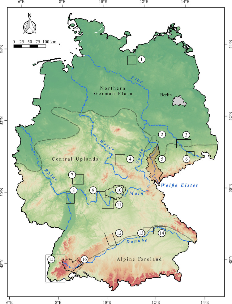
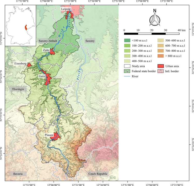
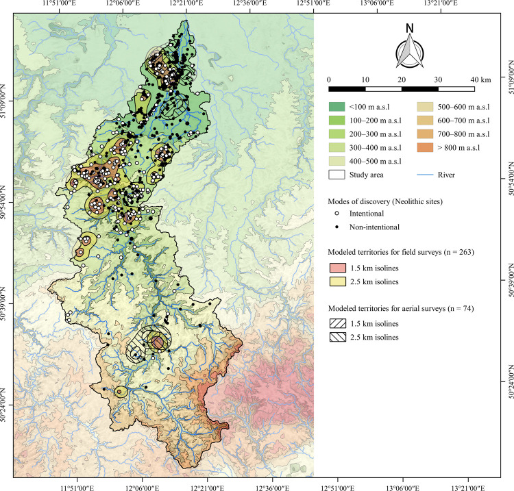
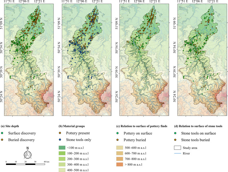
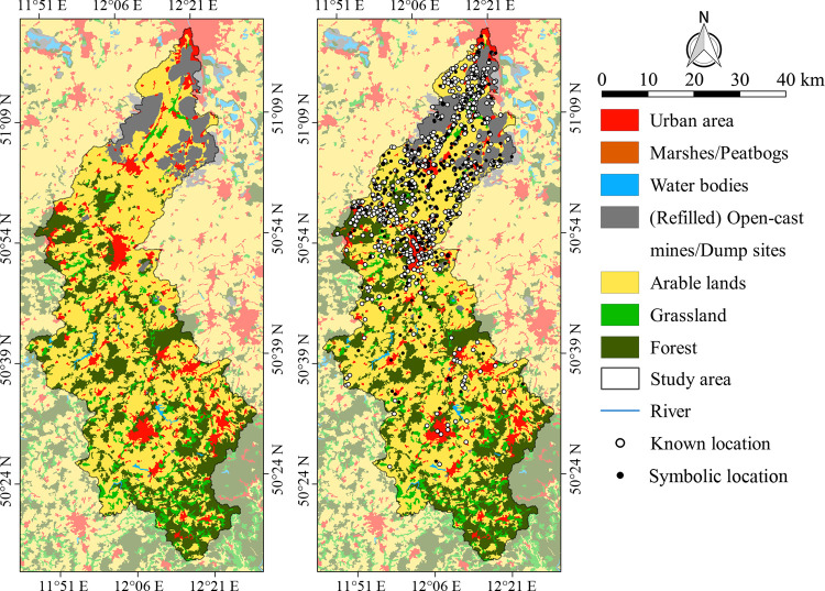
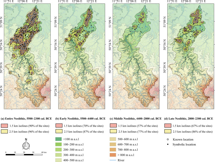
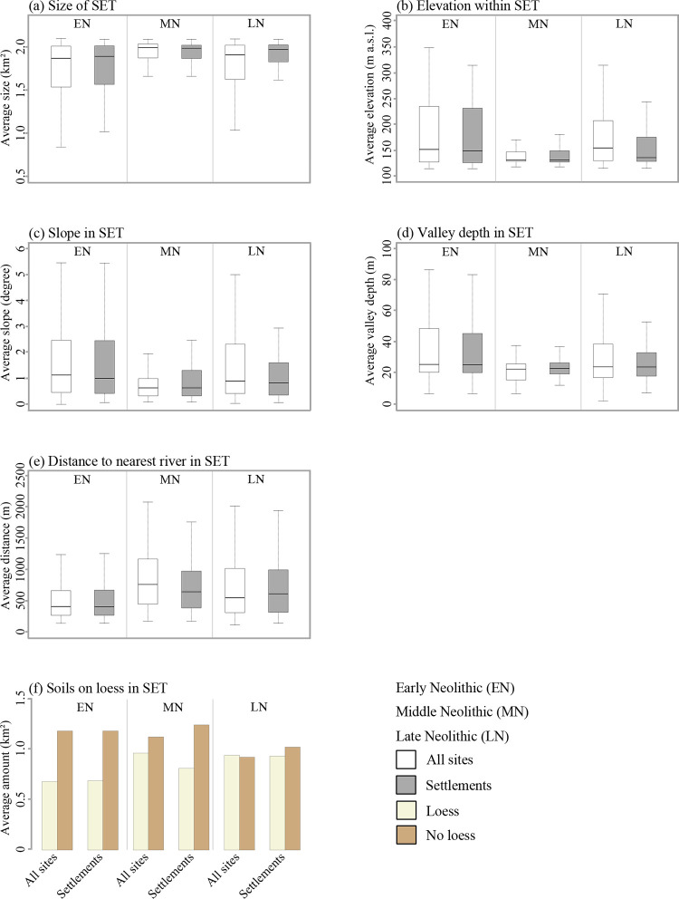
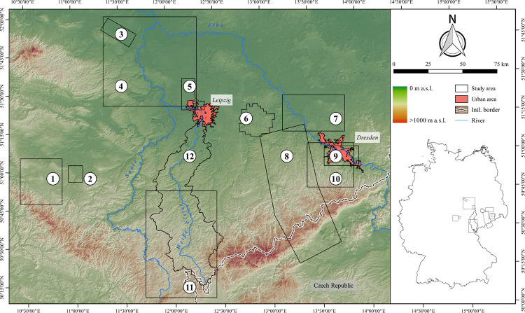
The paper investigates potentials and challenges during the interpretation of prehistoric settlement dynamics based on large archaeological datasets. Exemplarily, this is carried out using a database of 1365 Neolithic sites in the Weiße Elster river catchment in Central Germany located between the southernmost part of the Northern German Plain and the Central Uplands. The recorded sites are systematically pre-processed with regard to their chronology, functional interpretation and spatial delineation. The quality of the dataset is reviewed by analyzing site distributions with respect to field surveys and modern land use. The Random Forests machine learning algorithm is used to examine the impact of terrain covariates on the depth of sites and pottery preservation. Neolithic settlement dynamics are studied using Site Exploitation Territories, and site frequencies per century are used to compare the intensity of land use with adjacent landscapes. The results show that the main trends of the Neolithic settlement dynamics can be derived from the dataset. However, Random Forests analyses indicate poor pottery preservation in the Central Uplands and a superimposition of Neolithic sites in the southernmost part of the Northern German Plain. Throughout the Neolithic the margins between soils on loess and the Weiße Elster floodplain were continuously settled, whereas only Early and Late Neolithic land use also extended into the Central Uplands. These settlement patterns are reflected in the results of the Site Exploitation Territories analyses and explained with environmental economic factors. Similar with adjacent landscapes the Middle Neolithic site frequency is lower compared to earlier and later periods.


Conflict of interest statement

The authors have declared that no competing interests exist.

Figures

Fig 1
Fig 1. Diachronic studies with a focus on statistical analyses of long-term human-environment interactions between the Neolithic and the middle ages in Germany.
(1) Region between Lake Schwerin and Stepenitz [58], (2) north-west Saxony [57], (3) former district of Riesa-Großenhain [56], (4) Gotha landscape [33], (5) Weiße Elster river catchment (present project), (6) widening of the Elbe valley at Dresden [41], (7) northern Wetterau [59], (8) district of Groß-Gerau [29], (9) north-western Main triangle [55], (10) eastern landscape of Lower Franconia [54], (11) southern Main triangle [9], (12) Brenz-Kocher valley in the eastern Swabian Jura [10], (13) lower valley of the Altmühl river [53], (14) Danube valley near Regensburg [52], (15) southern Upper Rhine valley [32] and (16) the Baar and adjacent landscapes [12]. Furthermore, the three main landscape units of Germany are shown. Rivers are derived from the European Catchments and Rivers network system [60]. The topography is based on the SRTM 90 m Digital Elevation Database version 4.1 [–63].
Fig 2
Fig 2. Study area with respect to borders of federal states, international (intl.) borders, local topography and large urban areas mentioned in the text.
The outlines of the study area were extracted from the Catchment Characterisation Model database [82]. The political borders are drawn according to the Saxon State Office for Environment, Agriculture and Geology, the Saxony-Anhalt State Office for Surveying and Geoinformation and the Thuringian State Office for Land Management and Geoinformation. Rivers and urban areas are derived from the urban morphological zones dataset and the European Catchments and Rivers network system [83]. The topography is based on the SRTM 90 m Digital Elevation Database version 4.1 [–63]. Topography and rivers have been modified according to older topographic maps (S2 Fig).
Fig 3
Fig 3. Terminology and chronology of Neolithic periods in Germany.
For the Neolithic in Central Germany a selection of characteristic pottery and stone tools is added, drawings by Jan Miera.
Fig 4
Fig 4. Random forests confusion matrix according to van Rijsbergen [120].
Fig 5
Fig 5. Distribution of Neolithic sites with respect to their modes of discovery against the background of areas investigated by field surveys and aerial photography.
Rivers were plotted according to the European Catchments and Rivers network system [60]. The topography is based on the SRTM 90 m Digital Elevation Database version 4.1 [–63]. Topography and rivers have been modified according to older topographic maps (S2 Table). See Fig 2 for a location of the urban areas mentioned in the text.
Fig 6
Fig 6. Mapping of datasets used in random forests analyses.
(a) Site depth, (b) material groups (c) depth of pottery and (d) stone tools (Table 1). Rivers are plotted according to the European Catchments and Rivers network system [60]. The topography is based on the SRTM 90 m Digital Elevation Database version 4.1 [–63]. Topography and rivers have been modified according to older topographic maps (S2 Table). See Fig 2 for a location of the urban areas mentioned in the text.
Fig 7
Fig 7. Modern land use and Neolithic site distribution in the study area.
Distribution of modern land use classes according to CORINE Land Cover data [83]. The spatial extent of the (refilled) open-cast mines has been modified according to older topographic maps (S2 Table; S2 Fig).
Fig 8
Fig 8. Neolithic site densities in the study area.
(a) Entire Neolithic, (b) Early Neolithic, (c) Middle Neolithic and (d) Late Neolithic. Rivers were plotted according to the European Catchments and Rivers network system [60]. The topography is based on the SRTM 90 m Digital Elevation Database version 4.1 [–63]. Topography and rivers have been modified according to older topographic maps (S2 Table). See Fig 2 for a location of the urban areas mentioned in the text.
Fig 9
Fig 9. Analyses of site exploitation territories.
(a) Size of modelled SET, (b) terrain elevation, (c) slope, (d) valley depth, (e) river distance and (f) soils on loess and. For more information on each terrain covariate see S1 Table.
Fig 10
Fig 10. Study areas in Central Germany mentioned in the text and in Table 3.
(1) Gothaer Land [33], (2) Erfurt [200], (3) downstream section of the Bode river [201], (4) Elbe-Saale-Region [202], (5) North-West Saxony [57], (6) Lake Göttwitz [101], (7) former district of Riesa-Großenhain [56], (8) Ore Mountains [203], (9) Dresden Elbe valley [41], (10) Dresden Elbe valley and lower part of eastern Ore Mountains [204], (11) Vogtland [171], (12) catchment of the Weiße Elster river (this study).

Similar articles

References

    1. Cendrero A, Remondo J, Bonachea J, Rivas V, Soto J. Sensitivity of landscape evolution and geomorphic processes to direct and indirect human influence. Geografia Fisica e Dinamica Quaternaria. 2006; 29:125–137.
    1. Dotterweich M. The history of soil erosion and fluvial deposits in small catchments of central Europe: Deciphering the long-term interaction between humans and the environment—a review. Geomorphology. 2008; 101:192–208. 10.1016/j.geomorph.2008.05.023 - DOI
    1. Brown AG, Tooth S, Bullard JE, Thomas DSG, Chiverell RC, Plater AJ, et al.. The geomorphology of the Anthropocene: emergence, status and implications. Earth Surf Process Landf. 2017; 42:71–90. 10.1002/esp.3943 - DOI
    1. Menges J, Hovius N, Andermann C, Dietze M, Sowboda C, Cook CL, et al.. 2019. Late Holocene landscape collapse of a trans-Himalayan dryland: Human impact and aridification. Geophys Res Lett. 2019; 46:13814–13824. 10.1029/2019GL084192 - DOI
    1. Litt T, Schölzel C, Kühl N, Brauer A. Vegetation and climate history in the Westeifel Volcanic Field (Germany) during the past 11 000 years based on annually laminated lacustrine maar sediments. Boreas. 2009; 38:679–690. 10.1111/j.1502-3885.2009.00096.x - DOI

Publication types