

Multisensory GPS impact on spatial representation in an immersive virtual reality driving game
- PMID: 35513403
- PMCID: PMC9072375
- DOI: 10.1038/s41598-022-11124-9
Multisensory GPS impact on spatial representation in an immersive virtual reality driving game
Abstract
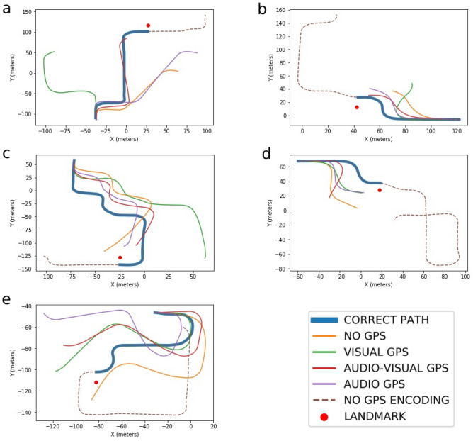
Individuals are increasingly relying on GPS devices to orient and find their way in their environment and research has pointed to a negative impact of navigational systems on spatial memory. We used immersive virtual reality to examine whether an audio-visual navigational aid can counteract the negative impact of visual only or auditory only GPS systems. We also examined the effect of spatial representation preferences and abilities when using different GPS systems. Thirty-four participants completed an IVR driving game including 4 GPS conditions (No GPS; audio GPS; visual GPS; audio-visual GPS). After driving one of the routes in one of the 4 GPS conditions, participants were asked to drive to a target landmark they had previously encountered. The audio-visual GPS condition returned more accurate performance than the visual and no GPS condition. General orientation ability predicted the distance to the target landmark for the visual and the audio-visual GPS conditions, while landmark preference predicted performance in the audio GPS condition. Finally, the variability in end distance to the target landmark was significantly reduced in the audio-visual GPS condition when compared to the visual and audio GPS conditions. These findings support theories of spatial cognition and inform the optimisation of GPS designs.
© 2022. The Author(s).
Conflict of interest statement
The authors declare no competing interests.
Figures


Similar articles
-
A feature and conjunction visual search immersive virtual reality serious game for measuring spatial and distractor inhibition attention using response time and action kinematics.J Clin Exp Neuropsychol. 2023 May;45(3):292-303. doi: 10.1080/13803395.2023.2218571. Epub 2023 Jun 1. J Clin Exp Neuropsychol. 2023. PMID: 37260369
-
The effect of the global positioning system on the driving performance of people with mild Alzheimer's disease.Gerontology. 2015;61(1):79-88. doi: 10.1159/000365922. Epub 2014 Oct 22. Gerontology. 2015. PMID: 25342271
-
Individual reactions to a multisensory immersive virtual environment: the impact of a wind farm on individuals.Cogn Process. 2012 Aug;13 Suppl 1:S319-23. doi: 10.1007/s10339-012-0492-6. Cogn Process. 2012. PMID: 22806673
-
Spatial Knowledge via Auditory Information for Blind Individuals: Spatial Cognition Studies and the Use of Audio-VR.Sensors (Basel). 2022 Jun 24;22(13):4794. doi: 10.3390/s22134794. Sensors (Basel). 2022. PMID: 35808291 Free PMC article. Review.
-
Keeping track of reality: embedding visual memory in natural behaviour.Memory. 2023 Nov;31(10):1295-1305. doi: 10.1080/09658211.2023.2260148. Epub 2023 Nov 21. Memory. 2023. PMID: 37727126 Review.
Cited by
-
How Do In-Car Navigation Aids Impair Expert Navigators' Spatial Learning Ability?Ann Am Assoc Geogr. 2024 Jul 1;114(7):1483-1504. doi: 10.1080/24694452.2024.2356858. eCollection 2024. Ann Am Assoc Geogr. 2024. PMID: 39193381 Free PMC article.
-
Navigating by Design: Effects of Individual Differences and Navigation Modality on Spatial Memory Acquisition.Behav Sci (Basel). 2025 Jul 15;15(7):959. doi: 10.3390/bs15070959. Behav Sci (Basel). 2025. PMID: 40723742 Free PMC article.
References
-
- Baroni, M. R. Psicologia ambientale. (Il Mulino, 2008).
-
- Burnett, G. E. & Lee, K. The effect of vehicle navigation systems on the formation of cognitive maps (2005).
-
- Ishikawa T, Fujiwara H, Imai O, Okabe A. Wayfinding with a GPS-based mobile navigation system: A comparison with maps and direct experience. J. Environ. Psychol. 2008;28:74–82. doi: 10.1016/j.jenvp.2007.09.002. - DOI
Publication types
MeSH terms
LinkOut - more resources
Full Text Sources
