. 2022 May 6;12(1):7468.
doi: 10.1038/s41598-022-11133-8.

The 2019-2020 volcanic eruption of Late'iki (Metis Shoal), Tonga

Affiliations

The 2019-2020 volcanic eruption of Late'iki (Metis Shoal), Tonga

I A Yeo et al. Sci Rep. .

Abstract

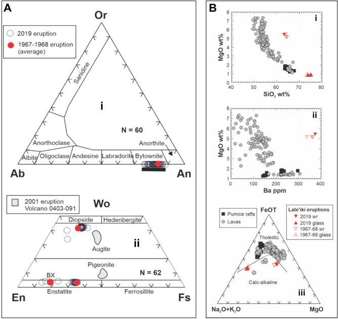
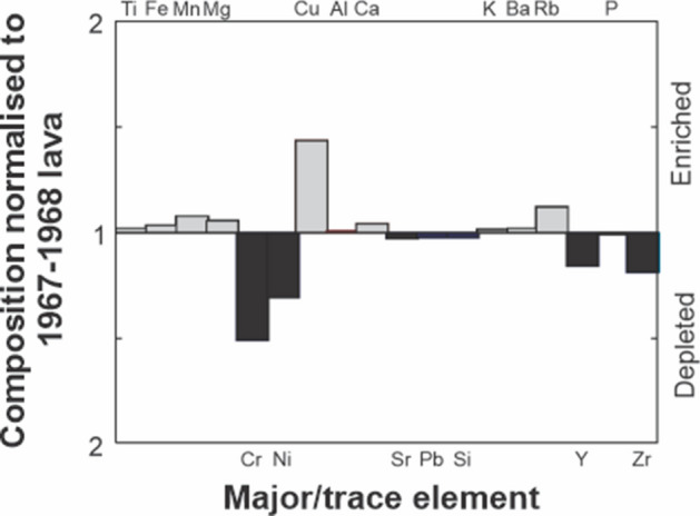
Late'iki (previously known as Metis Shoal) is a highly active volcano in the Tofua arc with at least four temporary island-building eruptions and one submarine eruption in the last 55 years. The most recent eruption, commencing in October 2019, resulted in lava effusion and subsequent phreatic explosions, the construction of a short-lived island that was quickly eroded by wave action and possibly further phreatic activity that continued into January 2020. The two-pyroxene dacite from the 2019 eruption is similar to the 1967/8 eruptions suggesting the magma is residual from earlier eruptions and has not undergone further differentiation in the last 50 years. New observations of the 2019 eruption site confirm the lava-dominant character of the volcano summit but a thin veneer of wave-reworked, finely fragmented lava material remains that is interpreted to have been produced by phreatic explosions from hot rock-water interactions during the effusive eruption. A notable absence of quench-fragmented hyaloclastite breccias suggests that non-explosive quench fragmentation processes were minimal at these shallow depths or that hyaloclastite debris has resedimented to greater depths beyond our summit survey area.


Conflict of interest statement

The authors declare no competing interests.

Figures

Figure 1
Figure 1
Late’iki location. Left hand panel shows the study area in its regional context. The bathymetry is reproduced from GEBCO Sheet G.08 compiled by R.L. Fisher of the Scripps Institution of Oceanography and extracted from the GEBCO Digital Atlas. The right hand panel shows Sentinel-2 satellite imagery of the eruption site on the 20th October 2019. Sampling locations and AUV track are plotted alongside locations of concentring ring waves and hydrothermal venting mapped from satellite imagery. The approximate locations of the photo mosaics from Fig. 4 are shown in yellow. The inset profile shows the water depths along the AUV track over the summit of Late’iki post eruption in February 2020.
Figure 2
Figure 2
Satellite imagery of the 2019–2020 eruption phases. (AI) Sentinel imagery showing the same region before, during and after the October 2019 eruption. Superimposed 100 m contours are from the GMRT grid but are not very accurate in this area and are for orientation only. (JL) MAXAR WorldView-2 and WorldView-3 satellite data of the region showing key events. Contours are the same as in panels (AI) but the maps are shown at a different scale. Red arrows in panel K show floating material in the water surrounding the volcano. (M) Drone view of the remains of New Late’iki island on December 3 (taken by Darren Rice of Matafonua Lodge). The island has been reduced to sea level, being continually wave swept and comprises outsized metre-sized blocks of dacitic lava resting on lapilli to ash sized fragmented lava material generated by phreatic explosions. The island is surrounded by an extensive hydrothermal plume.
Figure 3
Figure 3
Satellite observations of hydrothermal venting intensity, island area, white water caused by phreatic activity, concentric ring waves and floating material plotted against time in the period before, during and after the 2019 eruption. Island areas are plotted on two separate scales as New Late’iki was considerably larger than the pre-eruption island.
Figure 4
Figure 4
Seafloor imagery. (AC) Images captured from sampling sites GS46 (C), GS48 (B) and GS49 (A) showing thin layers of fine-grained material and blocky lavas on the NE side of the summit. (DF) Images taken by the UV along the track in Fig. 1 showing a range of summit features including altered cracks (D), hydrothermal vents (E) and bubbles in the water column (F). (GI) Photographic mosaics of several images showing the nature of the seafloor across the summit, including in the area of New Late’iki Island.
Figure 5
Figure 5
Photomicrographs of the 2019 Late’iki lava. (A) Plane polarised light view showing abundant, scattered pyroxene phenocrysts and highly vesicular glass. (B,C) Cross-polarised views showing polymineralic glomeroporphyritic textures, complexly zoned plagioclase and zoning in some pyroxene phenocrysts. Scale bar is 1 mm in all images.
Figure 6
Figure 6
(A) Phenocryst compositions of the Late’iki lavas produced in the 1967–1968 and 2019 eruptions. Averaged compositions for the 1967–1968 lava are from Ewart et al.. The data are further compared with phenocryst compositions from dacite pumice produced in the 2001 eruption of Volcano 0403-091, ~ 105 km to the north-northeast in the Tofua Arc. (i) Feldspar phenocryst compositions. Range of plagioclase compositions from the 2001 eruption of Volcano 0403-091 indicated by black bar. Ab albite, An anorthite, Or orthoclase, N number of analyses. (ii) Pyroxene phenocryst compositions expressed in terms of the three-component system: wollastonite (Wo), enstatite (En), and ferrosillite (Fs), with field boundaries after Morimoto. BX denotes the average composition of ‘bronzite’ xenocrysts identified by Ewart et al.. Grey shade indicates the field of pyroxene compositions from the 2001 eruption of volcano 0403-091/Volcano F. N is number of analyses. (B) Comparative geochemical plots of the Late’iki eruptions with erupted compositions from the Tofua arc (lavas are represented by grey filled circles, and pumice rafts-producing eruptions by blac-filled squares). (I) Harker plot of MgO vs SiO2 content showing the highly magnesian character of the 1967–2019 Late’iki dacite lavas, having an equivalent MgO content to basaltic andesites In the Tofua Arc. (Ii) MgO vs Ba plot illustrating the Late’iki lavas have distinctive trace element compositions and have the highest Ba contents of all analysed volcanics from the Tofua Arc. (Iii) AFM diagram comparing the Tofua Arc lavas and dacitic pumice compositions from pumice raft forming eruptions that form a typical tholeiitic trend. In contrast the Late’iki lavas exhibit chemical features resembling calc-alkali series rocks. Data for Tofua Arc lavas from. Pumice raft compositions from,,,. Compositions of the 1967–1968 Late’iki lava from,,.
Figure 7
Figure 7
Enrichment-depletion diagram showing the variation in major and trace elements for eruptions at Late’iki. The composition of the 2019 eruption is normalised to the composition of the 1967–1968 eruption. The diagram reveals only subtle differences in a few elements between 2019 and the 1967–1968 eruption, most of which is within analytical error.

References

    1. Bryan WB, Stice GD, Ewart A. Geology, petrography, and geochemistry of the volcanic islands of Tonga. J. Geophys. Res. 1972;77:1566–1585. doi: 10.1029/JB077i008p01566. - DOI
    1. Ewart A, Bryan WB, Gill JB. Mineralogy and Geochemistry of the Younger Volcanic Islands of Tonga, SW Pacific. J. Petrol. 1973;14:429–465. doi: 10.1093/petrology/14.3.429. - DOI
    1. Turner S, et al. Magma evolution in the primitive, intra-oceanic Tonga arc: Rapid petrogenesis of dacites at Fonualei volcano. J. Petrol. 2012;53:1231–1253. doi: 10.1093/petrology/egs005. - DOI
    1. Beier C, et al. Trace element and isotope geochemistry of the northern and central Tongan islands with an emphasis on the genesis of high Nb/Ta signatures at the northern volcanoes of Tafahi and Niuatoputapu. J. Petrol. 2017;58:1073–1106. doi: 10.1093/petrology/egx047. - DOI
    1. Ewart A. A petrological study of the younger Tongan andesites and dacites, and the olivine tholeiites of Niua Fo’ou Island, SW Pacific. Contrib. Mineral. Petrol. 1976;58:1–21. doi: 10.1007/BF00384740. - DOI

Publication types