. 2022 May 23;9(1):224.
doi: 10.1038/s41597-022-01313-6.

Characterizing storm-induced coastal change hazards along the United States West Coast

Affiliations

Characterizing storm-induced coastal change hazards along the United States West Coast

James B Shope et al. Sci Data. .

Abstract

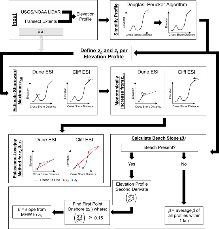
Traditional methods to assess the probability of storm-induced erosion and flooding from extreme water levels have limited use along the U.S. West Coast where swell dominates erosion and storm surge is limited. This effort presents methodology to assess the probability of erosion and flooding for the U.S. West Coast from extreme total water levels (TWLs), but the approach is applicable to coastal settings worldwide. TWLs were derived from 61 years of wave and water level data at shore-perpendicular transects every 100-m along open coast shorelines. At each location, wave data from the Global Ocean Waves model were downscaled to the nearshore and used to empirically calculate wave run-up. Tides were simulated using the Oregon State University's tidal data inversion model and non-tidal residuals were calculated from sea-surface temperature and pressure anomalies. Wave run-up was combined with still water levels to generate hourly TWL estimates and extreme TWLs for multiple return periods. Extremes were compared to onshore morphology to determine erosion hazards and define the probability of collision, overwash, and inundation.


Conflict of interest statement

The authors declare no competing interests.

Figures

Fig. 1
Fig. 1
Flow chart explaining the methodology employed in this study. The blue boxes indicate the individual components needed for the study, the red box indicates the final calculated product, and the green box indicates data available for download. The abbreviation NTRs represent non-tidal residuals described in the Extreme Total Water Levels section.
Fig. 2
Fig. 2
Flow chart detailing the LiDAR-derives shoreline morphology analysis from input LiDAR dataset, profiles locations, and Environmental Sensitivity Index (ESI) category. Note there are two separate calculation branches: one to evaluate dune/cliff crest (zc) and toe (zt) and another to calculate beach slope (β) for a given profile. zsm represents the intermediate calculation value of the most shoreward maximum along the simplified profile, d2z/dx2 is the second derivative of the simplified elevation profile, and zio is the first onshore point where the second derivative is >0.15 to define the upper bound for β calculation (as determined by testing).
Fig. 3
Fig. 3
Example elevation profiles in Santa Cruz County, Calif. of a cliff-backed beach (a) and a dune (b and c), with identified cliff and dune crest locations (zc) and toes (zt) locations relative to NAVD88 highlighted in blue and red, respectively. (a) Example beach slope (β) calculation for use with the Stockdon and others (2006) run-up formulation extending from the MHW location along the profile to zt, representing the cliff toe. (b) Example dune elevation with a modified elevation profile is shown in red, creating a continuous sloped profile onshore of the dune crest. (c) Dune elevation profile simplification and application of the Palaseanu-Lovejoy and others (2016) iterative adaptation to determine zt location. The dashed black line represents the original cross-shore morphology, the blue line represents the modified morphology to highlight the dune, and the red lines represent fit lines to iteratively identify zt.
Fig. 4
Fig. 4
Flow chart detailing total water level (TWL) calculations from wave model output, Environmental Sensitivity Index (ESI) category, and Digital Elevation Model (DEM) topography including run-up methodology selection and TWL magnitude evaluation. The runup method selected is indicated by the R2% subscript and TWL10-yr refers to the 10-year return period TWL at the transect. (µ + σ)10-yr region refers to the average 10-year TWL event for a predefined region including the transect plus the standard deviation of those regional values. The subscript i indicates the values used in TWL calculation at an individual time step.
Fig. 5
Fig. 5
Flow chart detailing selection of extreme value analysis method to generate the extreme total water level (TWL) and return periods. The shaded arrows in grey indicate the next step in the process if the conditions for the Confidence Interval in the corresponding boxes are met. The dark grey arrow indicates that the annual maxima GEV method is selected without testing the peaks over threshold method.
Fig. 6
Fig. 6
Example cumulative density function describing probabilities of potential total water levels (TWLs) and dynamic water levels (DWLs) plotted against zt and zc. The impact regime and fraction of the cumulative probability function is indicated on the right. The bold, black line represents the TWL probability; the bold, dash-dot line corresponds to the DWL probability; the dotted line is zt; and the dashed line is zc. Swash and collision probabilities are solely defined by the TWL probability cumulative density function (PCDF) intersecting zt and zc. Overtopping probability is defined by the difference of both TWL and DWL PCDF curves exceeding the zc, and inundation probability is solely defined by the DWL PCDF exceeding zc.
Fig. 7
Fig. 7
Significant wave height (Hs) propagation versus observed conditions for NDBC station 46027 Northwest of Crescent City, Calif. (a) Observed (blue line) versus propagated (orange line) Hs time series. (b) Quantile-Quantile plot of observed and modeled reconstruction Hs values for 27641 matching reconstructed and buoy records between 2005 and 2009. The red line represents the 1:1 line indicating perfect fit, the blue circles represent the quantile scatter, the black Xs represent a sample quantile pairing at increasing thresholds, and the dashed black line represents the best fit linear regression line for the quantile scatter.

References

    1. Stockdon, H. F. et al. National assessment of hurricane-induced coastal erosion hazards—Gulf of Mexico. U.S. Geological Survey Open-File Report 2012–1084 (2012).
    1. Stockdon, H. F., Doran, K. J., Thompson, D. M., Sopkin, K. L., & Plant, N. G. National assessment of hurricane-induced coastal erosion hazards: Southeast Atlantic Coast. U.S. Geological Survey Open-File Report 2013–1130 (2013).
    1. George DA, Largier JL, Storlazzi CD, Barnard PL. Classification of rocky headlands in California with relevance to littoral cell boundary delineation. Mar. Geol. 2015;369:137–152. doi: 10.1016/j.margeo.2015.08.010. - DOI
    1. Ruggiero, P., Hacker, S, Seabloom, E, & Zarnetske, P. The Role of Vegetation in Determining Dune Morphology, Exposure to Sea-Level Rise, and Storm-Induced Coastal Hazards: A U.S. Pacific Northwest Perspective. In Moore L., Murray A. (eds) Barrier Dynamics and Response to Changing Climate. (Springer, 2018).
    1. Barnard PL, et al. Dynamic flood modeling essential to assess the coastal impacts of climate change. Sci Rep. 2019;9:4309. doi: 10.1038/s41598-019-40742-z. - DOI - PMC - PubMed