. 2022 May 30;13(1):2989.
doi: 10.1038/s41467-022-30627-7.

Trans-crustal structural control of CO2-rich extensional magmatic systems revealed at Mount Erebus Antarctica

Affiliations

Trans-crustal structural control of CO2-rich extensional magmatic systems revealed at Mount Erebus Antarctica

G J Hill et al. Nat Commun. .

Erratum in

Abstract

Erebus volcano, Antarctica, with its persistent phonolite lava lake, is a classic example of an evolved, CO2-rich rift volcano. Seismic studies provide limited images of the magmatic system. Here we show using magnetotelluric data that a steep, melt-related conduit of low electrical resistivity originating in the upper mantle undergoes pronounced lateral re-orientation in the deep crust before reaching shallower magmatic storage and the summit lava lake. The lateral turn represents a structural fault-valve controlling episodic flow of magma and CO2 vapour, which replenish and heat the high level phonolite differentiation zone. This magmatic valve lies within an inferred, east-west structural trend forming part of an accommodation zone across the southern termination of the Terror Rift, providing a dilatant magma pathway. Unlike H2O-rich subduction arc volcanoes, CO2-dominated Erebus geophysically shows continuous magmatic structure to shallow crustal depths of < 1 km, as the melt does not experience decompression-related volatile supersaturation and viscous stalling.


Conflict of interest statement

The authors declare no competing interests.

Figures

Fig. 1
Fig. 1. Structural setting of the Mount Erebus magmatic system.
Site map showing impedance phase-tensor ellipses at the MT sounding locations over Mount Erebus and Ross Island during three field seasons; see text for color and shape designations. Coordinate ticks denote both UTM Zone 58S (singles) and latitude–longitude (doubles). Note the warm-colored ellipse region southwest of Mount Erebus indicating conductive volumes in the 0–7 km depth range approximately (Supplementary Information). Hypothesized Erebus fault zone contains principal low-resistivity structure resolved through the crust. The lower right inset shows regional structural setting, including the Ross Fault (green) in the accommodation zone of the terminus of the Terror Rift (TR) and Discovery graben (DG). Other symbols include Southern Victoria Land basin (SVL) and Discovery accommodation zone (D--A--Z). Yellow dashed lines represent other antithetic shear zones separating Dry Valleys block (DVB), Royal Society block (RSB), and Skelton block (SB). Volcano mounts include Bird (BR), Terror (TR), Terra Nova (TN), Erebus (ER), Hut Point (HP) Morning (MR), and Discovery (DS). Upper right inset places location of lower right view within Antarctica. The upper right orientation is ~180o rotated from the main and lower panels.
Fig. 2
Fig. 2. Map view resistivity sections.
Plan view model resistivity (ρ) slices at 3.3, 6.3, 13.9, and 56 km depths below sea level (ad) under Mount Erebus and Ross Island from 3D MT finite element inversion, MT measurement locations are marked by white circles. Inversion testing suggests that low resistivity representing deeper magmatic input from the upper mantle likely rises steeply under western Ross Island although precise depth extent is challenging to bracket. A small, almost circular feature near Northing 1395 and Easting 550 is outline of the Erebus summit plateau. An alternate color map version is provided as Supplementary Fig. S24.
Fig. 3
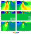
Fig. 3. Vertical-section view of resistivity structure.
E–W (a, c) and N–S (b, d) model resistivity (ρ) section views across Mt Erebus and Ross Island from 3D MT finite element inversion. The top two panels (a, b) pass through the active summit crater. The structural control slanting the main interpreted magma pathway to the west with depth from the summit is clear in the upper left panel (a). At greater distances south panel (c), the conductor tends to move out of the page toward the reader and downward as implied by panel (d). The dashed horizontal line segments at edges of sections (b) and (d) represent the seismic Moho,. The three volcanic summits are labeled Erebus (ER), Terra Nova (TN), and Terror (TR) in panels a and b. An alternate color map version is provided as Supplementary Fig. S25.
Fig. 4
Fig. 4. Resistivity model testing.
a E–W slice through Erebus summit of preferred inversion resistivity (ρ) model of Figs. 2 and 3; b E–W slice through Erebus summit of inversion model with all structure constrained to lie above the Moho,; c E–W slice through Erebus summit of synthetic inversion model derived from constrained inversion model response; df N–S slices analogous to the E–W views of (ac). The three volcanic summits are labeled Erebus (ER), Terra Nova (TN), and Terror (TR) on panels a and d. An alternate color map version is provided as Supplementary Fig. S26.
Fig. 5
Fig. 5. 3D resistivity model and magmatic processes.
a 3D visualization facing Mercator north of the 5 (red) and 10 (yellow) Ωm resistivity contours from the 3D finite element inversion. Gray band extending to 15 km depth is the conjectured Erebus fault zone (EFZ) within which the crustal Erebus conductor and possibly the minor Terra Nova conductor lie. Also shown is the projection of the deepest offset portion of the Discovery graben fault zone; b schematic depiction of magmatic processes conjectured to be occurring nominally in the core zone of the MT low resistivity, generally following recent petrological results,. Nominally, two channels of upward flow concentration from a deep-middle crustal throttle zone exemplify episodic breakthrough of CO2 and entrained magma. The convective melt zone drawn in the 4–8 km depth range is compatible with the inversion cross-section of Fig. 3b. Spatially continuous upflow of CO2-dominated magma is in contrast to depth-limited magma zones of H2O arc volcanoes.

References

    1. DasGupta R, Hirschmann MM, Smith ND. Partial melting experiments of peridotite+CO2 at 3 GPa and genesis of alkalic ocean island basalts. J. Petrol. 2007;48:2093–2124.
    1. Foley SF, Fischer TP. An essential role for continental rifts and lithosphere in the deep carbon cycle. Nat. Geosci. 2017;10:897–902.
    1. Kyle PR, Moore JA, Thirlwall MF. Petrologic evolution of anorthoclase phonolite lavas at Mount Erebus, Ross Island, Antarctica. J. Petrol. 1992;33:849–875.
    1. Kelly PJ, Kyle PR, Dunbar NW, Sims KWW. Geochemistry and mineralogy of the phonolite lava lake, Erebus, Antarctica:1972-2004 and comparison with older lavas. J. Volc. Geoth. Res. 2008;177:589–605.
    1. Self, S., Gertisser, R., Thordarson, T., Rampino, M. R., & Wolff, J. A. Magma volume, volatile emissions, and stratospheric aerosols from the 1815 eruption of Tambora. Geophys. Res. Lett. 31, 10.1029/2004GL020925 (2004).