

Potential of water quality wetlands to mitigate habitat losses from agricultural drainage modernization
- PMID: 35654186
- PMCID: PMC11773670
- DOI: 10.1016/j.scitotenv.2022.156358
Potential of water quality wetlands to mitigate habitat losses from agricultural drainage modernization
Abstract
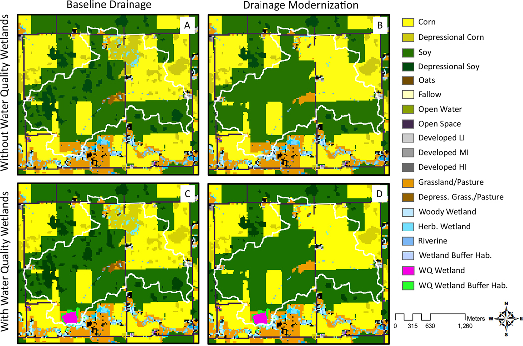
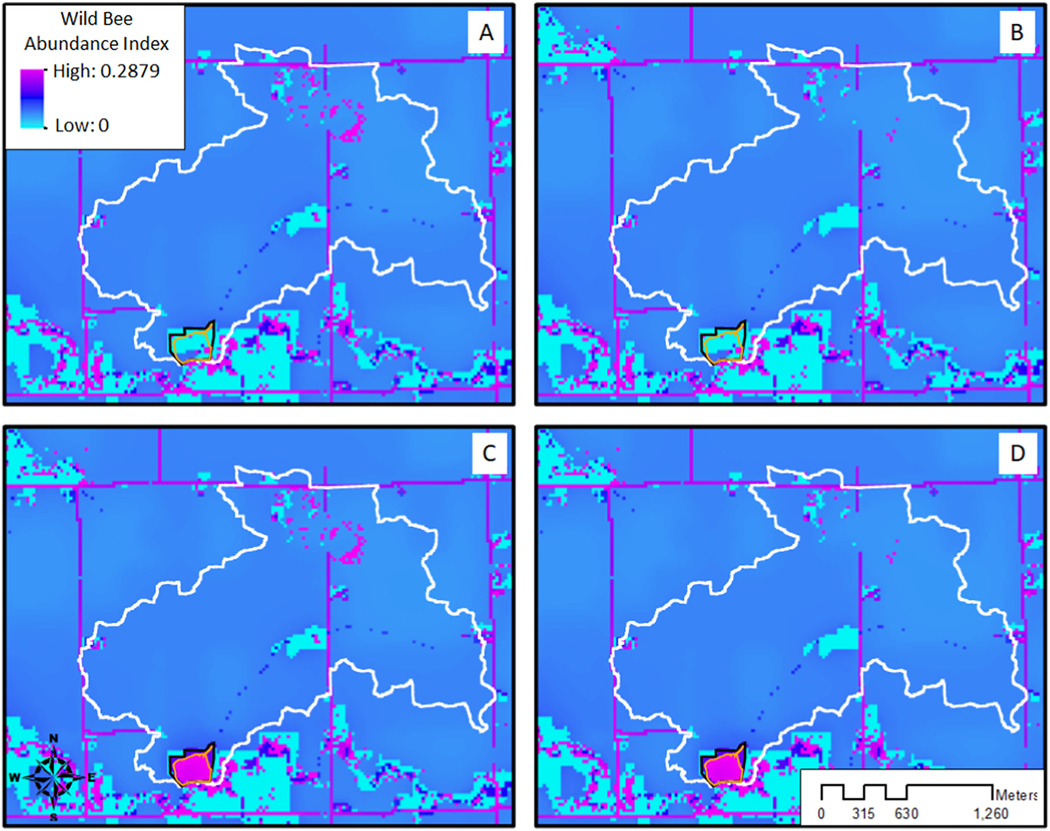
Given widespread biodiversity declines, a growing global human population, and demands to improve water quality, there is an immediate need to explore land management solutions that support multiple ecosystem services. Agricultural water quality wetlands designed to provide both water quality benefits and wetland and grassland habitat are an emerging restoration solution that may reverse habitat declines in intensive agricultural areas. Installation of water quality wetlands in the Upper Midwest, USA, when considered alongside the repair and modification of aging agricultural tile drainage infrastructure, is a likely scenario that may mitigate nutrient pollution exported from agricultural systems and improve crop yields. The capacity of water quality wetlands to provide habitat within the wetland pool and the surrounding grassland is not well-studied, particularly with respect to potential habitat changes resulting from drainage infrastructure upgrades. For the current study, we produced spatially explicit models of 37 catchments distributed throughout an important region for agriculture and biodiversity, the Des Moines Lobe of Iowa. Four scenarios were considered - with and without improved drainage and with and without water quality wetlands - to estimate the net potential habitat implications of these scenarios for amphibians, grassland birds, and wild bees. Model results indicate that drainage modification alone will likely result in moderate direct losses of suitable amphibian habitat and large declines in overall habitat quality. However, inclusion of water quality wetlands at the catchment scale may mitigate these amphibian habitat losses while also increasing grassland bird and pollinator habitat. The impacts of water quality wetlands and drainage modernization on waterfowl in the region require additional study.
Keywords: Agricultural intensification; Amphibians; Corn belt; Grassland birds; Pollinators.
Copyright © 2022. Published by Elsevier B.V.
Conflict of interest statement
Declaration of competing interest The authors declare that they have no known competing financial interests or personal relationships that could have appeared to influence the work reported in this paper.
Figures


References
-
- Agency EE, 1996. Human Interventions in the Hydrological Cycle.
-
- Babbitt KJ, Baber MJ, Tarr TL, 2003. Patterns of larval amphibian distribution along a wetland hydroperiod gradient. Can. J. Zool. 81 (9), 1539–1552.
-
- Balas CJ, Euliss NH, Mushet DM, 2012. Influence of conservation programs on amphibians using seasonal wetlands in the prairie pothole region. Wetlands 32 (2), 333–345.
-
- Ballard DC, Jones OE III, Janke AK, 2021. Factors affecting wetland use by spring migrating ducks in the southern prairie pothole region. J. Wildl. Manag 85 (7), 1490–1506.
-
- Blann KL, Anderson JL, Sands GR, Vondracek B, 2009. Effects of agricultural drainage on aquatic ecosystems: a review. Crit. Rev. Environ. Sci. Technol 39 (11), 909–1001.
MeSH terms
Grants and funding
LinkOut - more resources
Full Text Sources
