

doi: 10.1038/s41597-022-01393-4.
NASA Global Daily Downscaled Projections, CMIP6
Affiliations
- PMID: 35654862
- PMCID: PMC9163132
- DOI: 10.1038/s41597-022-01393-4
Item in Clipboard
NASA Global Daily Downscaled Projections, CMIP6
Sci Data.
.
Abstract
We describe the latest version of the NASA Earth Exchange Global Daily Downscaled Projections (NEX-GDDP-CMIP6). The archive contains downscaled historical and future projections for 1950-2100 based on output from Phase 6 of the Climate Model Intercomparison Project (CMIP6). The downscaled products were produced using a daily variant of the monthly bias correction/spatial disaggregation (BCSD) method and are at 1/4-degree horizontal resolution. Currently, eight variables from five CMIP6 experiments (historical, SSP126, SSP245, SSP370, and SSP585) are provided as procurable from thirty-five global climate models.
© 2022. The Author(s).
Conflict of interest statement
The authors declare no competing interests.
Figures
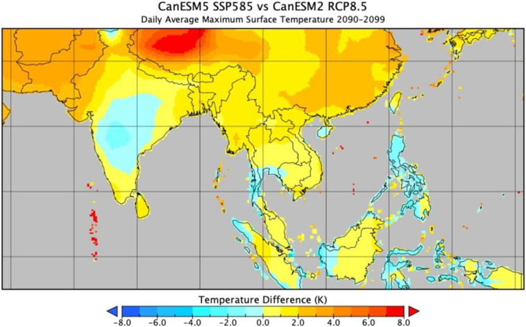
End of century daily average maximum near-surface air temperature difference between the downscaled CanESM5 model output (CMIP6) and the corresponding downscaled CanESM2 model output (CMIP5).
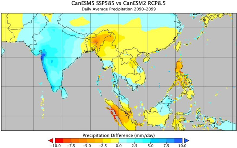
Same as Fig. 1, but for precipitation.
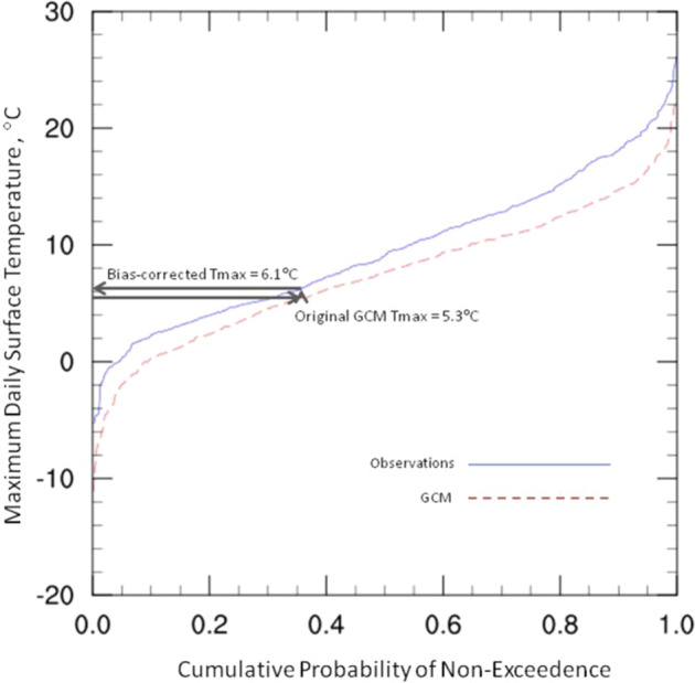
Example CDF for maximum daily near-surface temperature. Arrows illustrate the quantile mapping process used for bias correction. Adapted from Thrasher, et al., 2012.
References
-
- 2015. NASA Earth Exchange Global Daily Downscaled Projections (NEX-GDDP) https://www.nccs.nasa.gov/services/data-collections/land-based-products/...
-
- Wood, A. W., Maurer, E. P., Kumar, A. & Lettenmaier, D. P. Long-range experimental hydrologic forecasting for the eastern United States. J. of Geophysical Research-Atmospheres107 (2002).
-
- Wood AW, Leung LR, Sridhar V, Lettenmaier DP. Hydrologic implications of dynamical and statistical approaches to downscaling climate model outputs. Climatic Change. 2004;62:189–216. doi: 10.1023/B:CLIM.0000013685.99609.9e. - DOI
-
- Thrasher B, Maurer EP, McKellar C, Duffy PB. Technical Note: Bias correcting climate model simulated daily temperature extremes with quantile mapping. Hydrology and Earth System Sciences. 2012;16:3309–3314. doi: 10.5194/hess-16-3309-2012. - DOI
-
- Hwang S, Graham WD. Assessment of Alternative Methods for Statistically Downscaling Daily GCM Precipitation Outputs to Simulate Regional Streamflow. J. of the American Water Resources Assn. 2014;50(4):1010–1032. doi: 10.1111/jawr.12154. - DOI
Grants and funding
- NASA Earth Exchange (NEX) workplan (2018-2022)/NASA | Ames Research Center
- NASA Earth Exchange (NEX) workplan (2018-2022)/NASA | Ames Research Center
- NASA Earth Exchange (NEX) workplan (2018-2022)/NASA | Ames Research Center
- NASA Earth Exchange (NEX) workplan (2018-2022)/NASA | Ames Research Center
- NASA Earth Exchange (NEX) workplan (2018-2022)/NASA | Ames Research Center
LinkOut - more resources
Full Text Sources
