

Mapping HIV prevalence in Nigeria using small area estimates to develop a targeted HIV intervention strategy
- PMID: 35675346
- PMCID: PMC9176772
- DOI: 10.1371/journal.pone.0268892
Mapping HIV prevalence in Nigeria using small area estimates to develop a targeted HIV intervention strategy
Abstract
Objective: Although geographically specific data can help target HIV prevention and treatment strategies, Nigeria relies on national- and state-level estimates for policymaking and intervention planning. We calculated sub-state estimates along the HIV continuum of care in Nigeria.
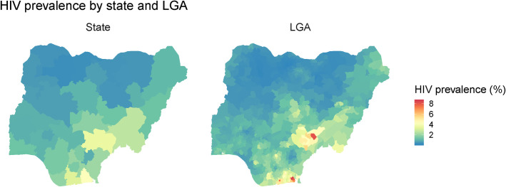
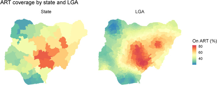
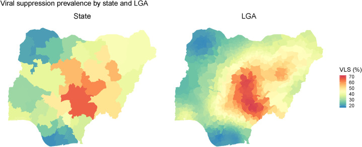
Design: Using data from the Nigeria HIV/AIDS Indicator and Impact Survey (NAIIS) (July-December 2018), we conducted a geospatial analysis estimating three key programmatic indicators: prevalence of HIV infection among adults (aged 15-64 years); antiretroviral therapy (ART) coverage among adults living with HIV; and viral load suppression (VLS) rate among adults living with HIV.
Methods: We used an ensemble modeling method called stacked generalization to analyze available covariates and a geostatistical model to incorporate the output from stacking as well as spatial autocorrelation in the modeled outcomes. Separate models were fitted for each indicator. Finally, we produced raster estimates of each indicator on an approximately 5×5-km grid and estimates at the sub-state/local government area (LGA) and state level.
Results: Estimates for all three indicators varied both within and between states. While state-level HIV prevalence ranged from 0.3% (95% uncertainty interval [UI]: 0.3%-0.5%]) to 4.3% (95% UI: 3.7%-4.9%), LGA prevalence ranged from 0.2% (95% UI: 0.1%-0.5%) to 8.5% (95% UI: 5.8%-12.2%). Although the range in ART coverage did not substantially differ at state level (25.6%-76.9%) and LGA level (21.9%-81.9%), the mean absolute difference in ART coverage between LGAs within states was 16.7 percentage points (range, 3.5-38.5 percentage points). States with large differences in ART coverage between LGAs also showed large differences in VLS-regardless of level of effective treatment coverage-indicating that state-level geographic targeting may be insufficient to address coverage gaps.
Conclusion: Geospatial analysis across the HIV continuum of care can effectively highlight sub-state variation and identify areas that require further attention in order to achieve epidemic control. By generating local estimates, governments, donors, and other implementing partners will be better positioned to conduct targeted interventions and prioritize resource distribution.
Conflict of interest statement
The authors have declared that no competing interests exist.
Figures
Similar articles
-
Towards achieving the 90-90-90 HIV targets: results from the south African 2017 national HIV survey.BMC Public Health. 2020 Sep 9;20(1):1375. doi: 10.1186/s12889-020-09457-z. BMC Public Health. 2020. PMID: 32907565 Free PMC article.
-
Factors associated with viral suppression among adults living with HIV on antiretroviral therapy in Nigeria: Analysis of a population-based survey, 2018.HIV Med. 2023 Jul;24(7):827-837. doi: 10.1111/hiv.13485. Epub 2023 Mar 21. HIV Med. 2023. PMID: 36945183 Free PMC article.
-
HIV treatment scale-up: a critical step to controlling HIV epidemic in a resource-limited country.Public Health. 2018 Nov;164:68-71. doi: 10.1016/j.puhe.2018.07.016. Epub 2018 Sep 8. Public Health. 2018. PMID: 30199742
-
Performance and trend for quality of service in a large HIV/AIDS treatment program in Nigeria.AIDS Res Ther. 2019 Oct 1;16(1):29. doi: 10.1186/s12981-019-0242-2. AIDS Res Ther. 2019. PMID: 31575377 Free PMC article. Review.
-
Updates to the Spectrum/AIM model for estimating key HIV indicators at national and subnational levels.AIDS. 2019 Dec 15;33 Suppl 3(Suppl 3):S227-S234. doi: 10.1097/QAD.0000000000002357. AIDS. 2019. PMID: 31805028 Free PMC article. Review.
Cited by
-
Spatial analysis and associated risk factors of HIV prevalence in Botswana: insights from the 2021 Botswana AIDS Impact Survey (BAIS V).BMC Infect Dis. 2025 Jan 16;25(1):69. doi: 10.1186/s12879-025-10464-x. BMC Infect Dis. 2025. PMID: 39815215 Free PMC article.
-
Improving HIV case finding using spatial data infrastructures in Anambra State, Nigeria: a pre-post intervention study.BMC Public Health. 2025 Feb 12;25(1):584. doi: 10.1186/s12889-025-21811-7. BMC Public Health. 2025. PMID: 39939893 Free PMC article.
-
Prevalence and Risk Factors for Mycobacterium tuberculosis Infection among Health Workers in HIV Treatment Centers in North Central, Nigeria.Am J Trop Med Hyg. 2023 May 30;109(1):60-68. doi: 10.4269/ajtmh.22-0531. Print 2023 Jul 5. Am J Trop Med Hyg. 2023. PMID: 37253444 Free PMC article.
-
Cervical Epithelial Abnormalities and Associated Factors among HIV-Infected Women in Lagos, Nigeria: A Cytology-Based Study.Acta Cytol. 2023;67(3):248-256. doi: 10.1159/000527905. Epub 2022 Dec 14. Acta Cytol. 2023. PMID: 36516788 Free PMC article.
-
Spatial Co-Clustering of Tuberculosis and HIV in Ethiopia.Diseases. 2022 Nov 17;10(4):106. doi: 10.3390/diseases10040106. Diseases. 2022. PMID: 36412600 Free PMC article.
References
Publication types
MeSH terms
Grants and funding
LinkOut - more resources
Full Text Sources
Medical
