

A westerly wind dominated Puna Plateau during deposition of upper Pleistocene loessic sediments in the subtropical Andes, South America
- PMID: 35701433
- PMCID: PMC9197825
- DOI: 10.1038/s41467-022-31118-5
A westerly wind dominated Puna Plateau during deposition of upper Pleistocene loessic sediments in the subtropical Andes, South America
Abstract
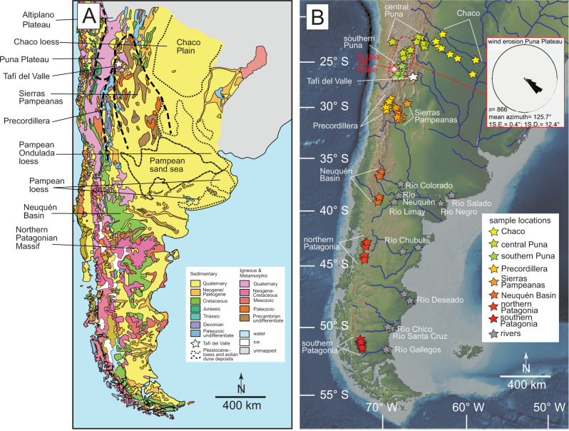
The Tafí del Valle depression (~27° S) in the eastern Andes of Argentina provides a record of late Pleistocene dust deposition in the subtropics of South America. We present large-n U-Pb geochronology data for detrital zircons from upper Pleistocene loess-paleosol deposits. When compared to regional data, the age spectra from the Tafí del Valle samples are most like the southern Puna Plateau, supporting derivation largely from the west and northwest. This runs counter to hypotheses suggesting these loessic sediments were derived from the low elevation plains to the east or extra-Andean Patagonia. Mapping of linear wind erosion features on the Puna Plateau yield a mean orientation of 125.7° (1 s.d. = 12.4°). These new data and existing records are consistent with a westerly-northwesterly dominated (upper- and lower-level) wind system over the southern Puna Plateau (to at least ~27° S) during periods of high dust accumulation in Tafí del Valle.
© 2022. The Author(s).
Conflict of interest statement
The authors declare no competing interests.
Figures


References
-
- Vitousek PM, Sanford RL., Jr Nutrient cycling in moist tropical forest. Annu. Rev. Ecol. Syst. 1986;17:137–167. doi: 10.1146/annurev.es.17.110186.001033. - DOI
-
- Yu H, et al. The fertilizing role of African dust in the Amazon rainforest: A first multiyear assessment based on data from Cloud‐Aerosol Lidar and Infrared Pathfinder Satellite Observations. Geophys. Res. Lett. 2015;42:1984–1991. doi: 10.1002/2015GL063040. - DOI
-
- Martin JH, Gordon RM, Fitzwater SE. Iron in Antarctic waters. Nature. 1990;345:156. doi: 10.1038/345156a0. - DOI
Publication types
MeSH terms
Substances
LinkOut - more resources
Full Text Sources
