. 2022 Jun 21;12(1):10472.
doi: 10.1038/s41598-022-14569-0.

A functional definition to distinguish ponds from lakes and wetlands

Affiliations

A functional definition to distinguish ponds from lakes and wetlands

David C Richardson et al. Sci Rep. .

Abstract

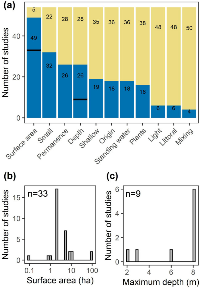
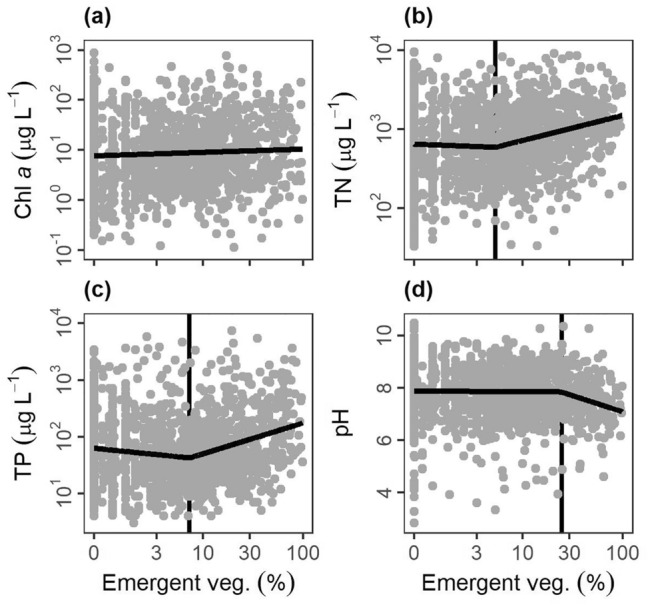
Ponds are often identified by their small size and shallow depths, but the lack of a universal evidence-based definition hampers science and weakens legal protection. Here, we compile existing pond definitions, compare ecosystem metrics (e.g., metabolism, nutrient concentrations, and gas fluxes) among ponds, wetlands, and lakes, and propose an evidence-based pond definition. Compiled definitions often mentioned surface area and depth, but were largely qualitative and variable. Government legislation rarely defined ponds, despite commonly using the term. Ponds, as defined in published studies, varied in origin and hydroperiod and were often distinct from lakes and wetlands in water chemistry. We also compared how ecosystem metrics related to three variables often seen in waterbody definitions: waterbody size, maximum depth, and emergent vegetation cover. Most ecosystem metrics (e.g., water chemistry, gas fluxes, and metabolism) exhibited nonlinear relationships with these variables, with average threshold changes at 3.7 ± 1.8 ha (median: 1.5 ha) in surface area, 5.8 ± 2.5 m (median: 5.2 m) in depth, and 13.4 ± 6.3% (median: 8.2%) emergent vegetation cover. We use this evidence and prior definitions to define ponds as waterbodies that are small (< 5 ha), shallow (< 5 m), with < 30% emergent vegetation and we highlight areas for further study near these boundaries. This definition will inform the science, policy, and management of globally abundant and ecologically significant pond ecosystems.


Conflict of interest statement

The authors declare no competing interests.

Figures

Figure 1
Figure 1
We call lentic waterbodies by a variety of names in the English language including ponds, lakes, wetlands, reservoirs, oxbows, prairie potholes, vernal pools, lagoons, dams, puddles, and shallow lakes. These names may or may not correspond to ecological and systematic differences. Generally, laypeople and experts, as individuals, will quickly differentiate among broad categories of ponds, lakes, and wetlands; however, individuals may respond in different ways depending on their background and experiences. We present three different images of waterbodies that could each be categorized as lake, pond, or wetland using objective (e.g., morphology or vegetative cover) or more subjective criteria keeping cognizant of the complexity within and potential overlap among waterbody types.
Figure 2
Figure 2
Summary of “pond” definitions from scientific literature including (a) presence of various morphological, biological, and physical characteristics in the definition as blue bars (n = 54 definitions total). Bold black lines indicate the number of definitions with surface area and depth values. Histograms of the upper limits from “pond” definitions for (b) surface area and (c) maximum depth.
Figure 3
Figure 3
US state responses to surveys indicating if the state has a definition of wetland, lake, or pond and if the state used the term “pond” in their legislation. NR = no response.
Figure 4
Figure 4
Comparison of various chemical and biological parameters across wetlands, ponds, and lakes, with waterbody category based on the term used by publishing scientists and managers (Table S2). Violin plots indicate distributions of waterbody characteristics, the white box indicates 25th to 75th percentile with median in the middle, whiskers indicate 1.5 × interquartile range, and outliers are black closed circles. Letters inside the plot indicate significant differences in means (LSD, alpha = 0.05). Note all x-axes have logarithmic scales.
Figure 5
Figure 5
Relationships between lentic waterbody size (excluding wetlands) and ecosystem structure and function metrics: (a) gross primary production (GPP), (b) total phosphorus concentrations (TP), (c) net ecosystem production (NEP), (d) methane fluxes (CH4 flux), (e) respiration (R), (f) chlorophyll a concentrations (Chl a), (g) total nitrogen concentrations (TN), (h) diel temperature ranges (DTR), and (i) gas transfer piston velocity (k600). Optimal model fits from null, linear, segmented, and logistic curves in bold foreground lines. For nonlinear segmented and logistic models (bi), plots are ordered by boundaries between ponds and lakes, as defined by model breakpoints or inflection points (vertical background lines).
Figure 6
Figure 6
Relationships between lentic waterbody maximum depth (Max depth) and various ecosystem structure and function metrics: (a) methane fluxes (CH4 flux), (b) pH, (c) total phosphorus concentrations (TP), (d) total nitrogen concentrations (TN), (e) diel temperature ranges (DTR), and (f) chlorophyll a concentrations (Chl a) from literature data extraction with optimal model fits from null, linear or null, segmented linear, and logistic curves in bold foreground lines. For nonlinear segmented and logistic models (bf), plots are ordered by model breakpoints or inflection points (vertical background lines), indicative of boundaries between ponds and lakes.
Figure 7
Figure 7
Relationships between lentic waterbody emergent vegetation cover (Emergent veg.) and various ecosystem structure and function metrics: (a) chlorophyll a concentrations (Chl a), (b) total nitrogen concentrations (TN), (c) total phosphorus concentrations (TP), (d) pH from literature data extraction with optimal model fits from null, linear or null, segmented linear, and logistic curves in bold foreground lines. For nonlinear segmented and logistic models (bd), plots are ordered by model breakpoints or inflection points (vertical background lines), indicative of boundaries between ponds and wetlands.
Figure 8
Figure 8
Conceptual model to define lentic waterbodies based on three different criteria (depth, surface area, and emergent vegetation). Boundaries for all three axes come from our analysis and are informed by existing pond, lake, and wetland definitions. Figure by Visualizing Science.

References

    1. Alexander LC. Science at the boundaries: Scientific support for the Clean Water Rule. Freshw. Sci. 2015;34:1588–1594. doi: 10.1086/684076. - DOI
    1. Kraemer BM. Rethinking discretization to advance limnology amid the ongoing information explosion. Water Res. 2020;178:115801. doi: 10.1016/j.watres.2020.115801. - DOI - PubMed
    1. Verpoorter C, Kutser T, Seekell DA, Tranvik LJ. A global inventory of lakes based on high-resolution satellite imagery. Geophys. Res. Lett. 2014;41:6396–6402. doi: 10.1002/2014GL060641. - DOI
    1. Holgerson MA, Raymond PA. Large contribution to inland water CO2 and CH4 emissions from very small ponds. Nat. Geosci. 2016;9:222–226. doi: 10.1038/ngeo2654. - DOI
    1. Dodds WK, Cole JJ. Expanding the concept of trophic state in aquatic ecosystems: It’s not just the autotrophs. Aquat. Sci. 2007;69:427–439. doi: 10.1007/s00027-007-0922-1. - DOI

Publication types