Review
. 2022 Sep:40:100597.
doi: 10.1016/j.epidem.2022.100597. Epub 2022 Jun 17.

Small area population denominators for improved disease surveillance and response

Affiliations
Review

Small area population denominators for improved disease surveillance and response

A J Tatem. Epidemics. 2022 Sep.

Abstract

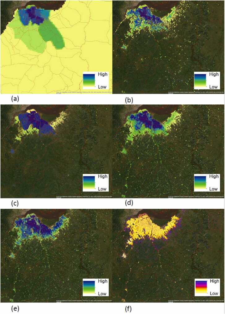
The Covid-19 pandemic has highlighted the value of strong surveillance systems in supporting our abilities to respond rapidly and effectively in mitigating the impacts of infectious diseases. A cornerstone of such systems is basic subnational scale data on populations and their demographics, which enable the scale of outbreaks to be assessed, risk to specific groups to be determined and appropriate interventions to be designed. Ongoing weaknesses and gaps in such data have however been highlighted by the pandemic. These can include outdated or inaccurate census data and a lack of administrative and registry systems to update numbers, particularly in low and middle income settings. Efforts to design and implement globally consistent geospatial modelling methods for the production of small area demographic data that can be flexibly integrated into health-focussed surveillance and information systems have been made, but these often remain based on outdated population data or uncertain projections. In recent years, efforts have been made to capitalise on advances in computing power, satellite imagery and new forms of digital data to construct methods for estimating small area population distributions across national and regional scales in the absence of full enumeration. These are starting to be used to complement more traditional data collection approaches, especially in the delivery of health interventions, but barriers remain to their widespread adoption and use in disease surveillance and response. Here an overview of these approaches is presented, together with discussion of future directions and needs.

Keywords: Census; Geospatial modelling; Health information systems; Population mapping; Satellite imagery.


Conflict of interest statement

Declaration of Competing Interest None.

Figures

Fig. 1
Fig. 1
Maps for the region encompassing the five most westerly provinces of the Democratic Republic of the Congo (Kinshasa, Kongo-Central, Kwango, Kwilu, and Mai-Ndombe, as shown in (a)), showing proportions of the total population of the region estimated to be in each health zone for a set of commonly used open gridded population datasets: (b) Gridded Population of the World version 4 (GPWv4) (Center for International Earth Science Information Network - CIESIN - Columbia University, 2018b), (c) GHS Population grid (Florczyk et al., 2019), (d) Meta Data for Good High resolution population density maps (Meta Data for Good, 2022), (e) WorldPop global constrained top down estimates (Bondarenko et al., 2020), (f) WorldPop/GRID3 bottom up population estimates (Boo et al., 2020).
Fig. 2
Fig. 2
Gridded population estimates from the same datasets as Fig. 1 for Kinshasa and surrounding area in the Democratic Republic of the Congo, with health areas overlaid. The extent of the area shown is highlighted in the black box in Fig. 1(a). Each dataset has been displayed using a scale of 20 quantiles within the area shown to highlight the inherent population distribution patterns. (a) Gridded Population of the World version 4 (GPWv4) (Center for International Earth Science Information Network - CIESIN - Columbia University, 2018b), (b) GHS Population grid (Florczyk et al., 2019), (c) Meta Data for Good High resolution population density maps (Meta Data for Good, 2022), (d) WorldPop global constrained top down estimates (Bondarenko et al., 2020), (e) WorldPop/GRID3 bottom up population estimates (Boo et al., 2020), (f) uncertainty of WorldPop/GRID3 bottom up population estimates, measured as the difference between the upper and lower 95 % credible intervals of the posterior prediction divided by the mean of the posterior prediction.

References

    1. Aborode A.T., et al. Impact of poor disease surveillance system on COVID-19 response in africa: time to rethink and rebuilt. Clin. Epidemiol. Glob. Health. 2021;12 - PMC - PubMed
    1. Alegana V.A., et al. Fine resolution mapping of population age-structures for health and development applications. J. R. Soc. Interface. 2015;12:105. - PMC - PubMed
    1. Ali D., et al. A cost-effectiveness analysis of traditional and geographic information system-supported microplanning approaches for routine immunization program management in northern Nigeria. Vaccine. 2020;38(6):1408–1415. - PubMed
    1. Bengtsson L., et al. Improved response to disasters and outbreaks by tracking population movements with mobile phone network data: a post-earthquake geospatial study in Haiti. PLoS Med. 2011;8(8) - PMC - PubMed
    1. Bergroth C., et al. A 24-hour population distribution dataset based on mobile phone data from Helsinki Metropolitan Area, Finland. Sci. Data. 2022;9(1):39. - PMC - PubMed

Publication types