

Making marine image data FAIR
- PMID: 35840583
- PMCID: PMC9287444
- DOI: 10.1038/s41597-022-01491-3
Making marine image data FAIR
Erratum in
-
Publisher Correction: Making marine image data FAIR.Sci Data. 2022 Jul 26;9(1):445. doi: 10.1038/s41597-022-01567-0. Sci Data. 2022. PMID: 35882873 Free PMC article. No abstract available.
Abstract
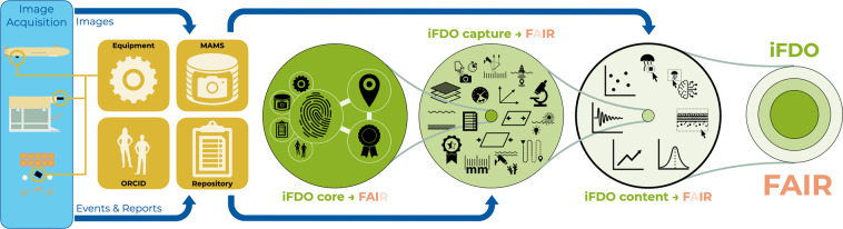
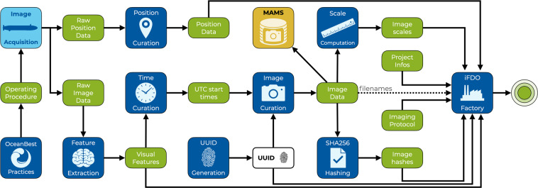
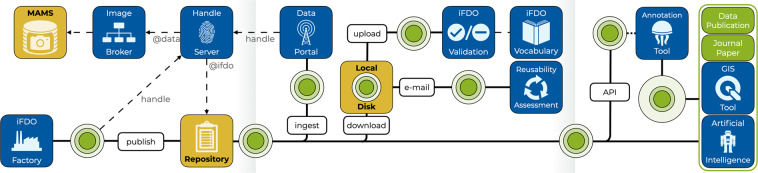
Underwater images are used to explore and monitor ocean habitats, generating huge datasets with unusual data characteristics that preclude traditional data management strategies. Due to the lack of universally adopted data standards, image data collected from the marine environment are increasing in heterogeneity, preventing objective comparison. The extraction of actionable information thus remains challenging, particularly for researchers not directly involved with the image data collection. Standardized formats and procedures are needed to enable sustainable image analysis and processing tools, as are solutions for image publication in long-term repositories to ascertain reuse of data. The FAIR principles (Findable, Accessible, Interoperable, Reusable) provide a framework for such data management goals. We propose the use of image FAIR Digital Objects (iFDOs) and present an infrastructure environment to create and exploit such FAIR digital objects. We show how these iFDOs can be created, validated, managed and stored, and which data associated with imagery should be curated. The goal is to reduce image management overheads while simultaneously creating visibility for image acquisition and publication efforts.
© 2022. The Author(s).
Conflict of interest statement
The authors declare no competing interests.
Figures
References
-
- Huvenne VAI, Bett BJ, Masson DG, Le Bas TP, Wheeler AJ. Effectiveness of a deep-sea cold-water coral Marine Protected Area, following eight years of fisheries closure. Biol. Conserv. 2016;200:60–69.
-
- Schoening, T. Automated detection in benthic images for megafauna classification and marine resource exploration: supervised and unsupervised methods for classification and regression tasks in benthic images with efficient integration of expert knowledge. (2015).
-
- Game ET, et al. Pelagic protected areas: the missing dimension in ocean conservation. Trends Ecol. Evol. 2009;24:360–369. - PubMed
Publication types
Grants and funding
- 818123/EC | Horizon 2020 Framework Programme (EU Framework Programme for Research and Innovation H2020)
- 871153/EC | Horizon 2020 Framework Programme (EU Framework Programme for Research and Innovation H2020)
- FRAM/Alfred Wegener Institute Helmholtz Centre for Polar and Marine Research (Alfred-Wegener- Institute, Helmholtz Centre for Polar and Marine Research)
- HO 5569/2-1/Deutsche Forschungsgemeinschaft (German Research Foundation)
- 396311425/Deutsche Forschungsgemeinschaft (German Research Foundation)
LinkOut - more resources
Full Text Sources
