

How accurate are WorldPop-Global-Unconstrained gridded population data at the cell-level?: A simulation analysis in urban Namibia
- PMID: 35862480
- PMCID: PMC9302737
- DOI: 10.1371/journal.pone.0271504
How accurate are WorldPop-Global-Unconstrained gridded population data at the cell-level?: A simulation analysis in urban Namibia
Abstract
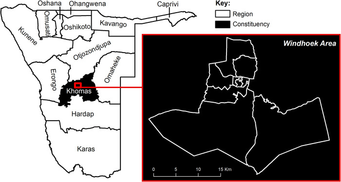
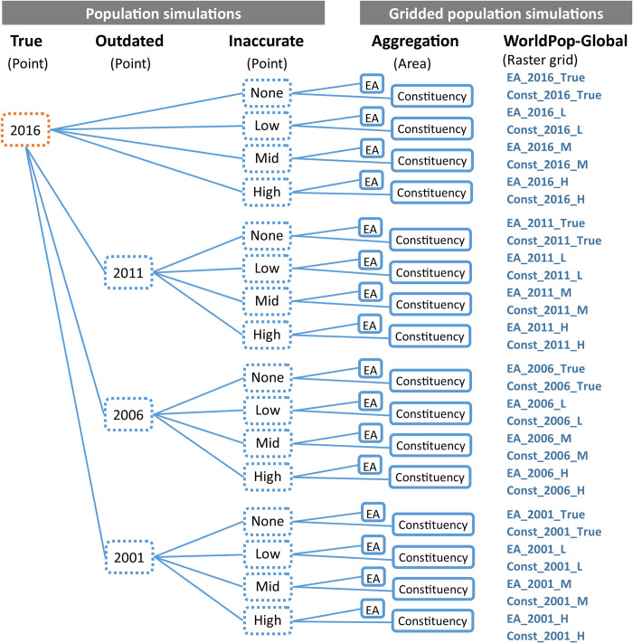
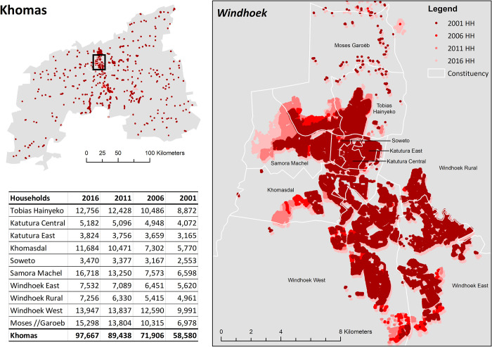
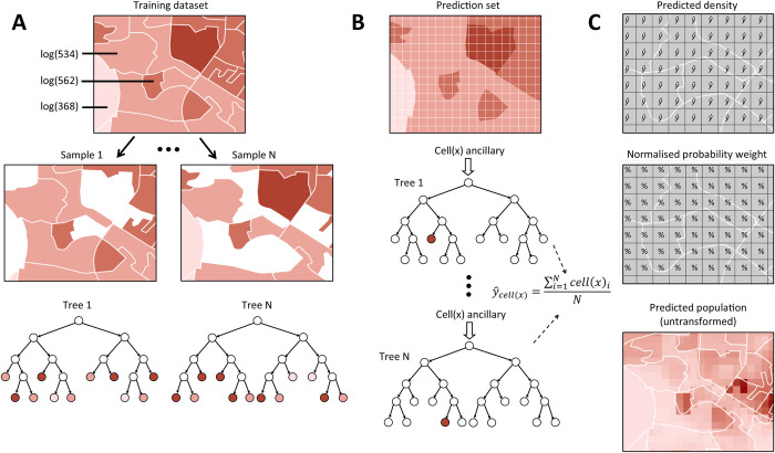
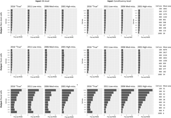
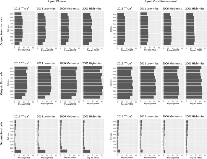
Disaggregated population counts are needed to calculate health, economic, and development indicators in Low- and Middle-Income Countries (LMICs), especially in settings of rapid urbanisation. Censuses are often outdated and inaccurate in LMIC settings, and rarely disaggregated at fine geographic scale. Modelled gridded population datasets derived from census data have become widely used by development researchers and practitioners; however, accuracy in these datasets are evaluated at the spatial scale of model input data which is generally courser than the neighbourhood or cell-level scale of many applications. We simulate a realistic synthetic 2016 population in Khomas, Namibia, a majority urban region, and introduce several realistic levels of outdatedness (over 15 years) and inaccuracy in slum, non-slum, and rural areas. We aggregate the synthetic populations by census and administrative boundaries (to mimic census data), resulting in 32 gridded population datasets that are typical of LMIC settings using the WorldPop-Global-Unconstrained gridded population approach. We evaluate the cell-level accuracy of these gridded population datasets using the original synthetic population as a reference. In our simulation, we found large cell-level errors, particularly in slum cells. These were driven by the averaging of population densities in large areal units before model training. Age, accuracy, and aggregation of the input data also played a role in these errors. We suggest incorporating finer-scale training data into gridded population models generally, and WorldPop-Global-Unconstrained in particular (e.g., from routine household surveys or slum community population counts), and use of new building footprint datasets as a covariate to improve cell-level accuracy (as done in some new WorldPop-Global-Constrained datasets). It is important to measure accuracy of gridded population datasets at spatial scales more consistent with how the data are being applied, especially if they are to be used for monitoring key development indicators at neighbourhood scales within cities.
Conflict of interest statement
The authors have declared that no competing interests exist.
Figures
Similar articles
-
Gridded population survey sampling: a systematic scoping review of the field and strategic research agenda.Int J Health Geogr. 2020 Sep 9;19(1):34. doi: 10.1186/s12942-020-00230-4. Int J Health Geogr. 2020. PMID: 32907588 Free PMC article.
-
GridSample: an R package to generate household survey primary sampling units (PSUs) from gridded population data.Int J Health Geogr. 2017 Jul 19;16(1):25. doi: 10.1186/s12942-017-0098-4. Int J Health Geogr. 2017. PMID: 28724433 Free PMC article.
-
Global gridded population datasets systematically underrepresent rural population.Nat Commun. 2025 Mar 18;16(1):2170. doi: 10.1038/s41467-025-56906-7. Nat Commun. 2025. PMID: 40102392 Free PMC article.
-
Using gridded population and quadtree sampling units to support survey sample design in low-income settings.Int J Health Geogr. 2020 Mar 26;19(1):10. doi: 10.1186/s12942-020-00205-5. Int J Health Geogr. 2020. PMID: 32216801 Free PMC article.
-
From top to bottom: gridded human population estimates in data-poor situations.Rev Sci Tech. 2023 May;42:111-119. doi: 10.20506/rst.42.3354. Rev Sci Tech. 2023. PMID: 37232314 Review. English.
Cited by
-
Global population datasets overestimate flood exposure in Sweden.Sci Rep. 2024 Sep 2;14(1):20410. doi: 10.1038/s41598-024-71330-5. Sci Rep. 2024. PMID: 39223219 Free PMC article.
-
Tracking air pollution and CO2 emissions in 13,189 urban areas worldwide using large geospatial datasets.Commun Earth Environ. 2025;6(1):311. doi: 10.1038/s43247-025-02270-9. Epub 2025 May 7. Commun Earth Environ. 2025. PMID: 40352317 Free PMC article.
-
A geospatial analysis of accessibility and availability to implement the primary healthcare roadmap in Ethiopia.Commun Med (Lond). 2023 Oct 7;3(1):140. doi: 10.1038/s43856-023-00372-z. Commun Med (Lond). 2023. PMID: 37805668 Free PMC article.
-
A subnational reproductive, maternal, newborn, child, and adolescent health and development atlas of India.Sci Data. 2023 Feb 10;10(1):86. doi: 10.1038/s41597-023-01961-2. Sci Data. 2023. PMID: 36765058 Free PMC article.
-
Improved Indicators for Subnational Unmet Antiretroviral Therapy Need in the Health System: Updates to the Naomi Model in 2023.J Acquir Immune Defic Syndr. 2024 Jan 1;95(1S):e24-e33. doi: 10.1097/QAI.0000000000003324. Epub 2024 Jan 4. J Acquir Immune Defic Syndr. 2024. PMID: 38180736 Free PMC article.
References
-
- UN Human Settlements Programme (UN-Habitat). World cities report 2020: the value of sustainable urbanization. Nairobi: UN-Habitat; 2020. 377 p.
-
- Turok I, McGranahan G. Urbanization and economic growth: the arguments and evidence for Africa and Asia. Environ Urban. 2013;25(2):465–82. doi: 10.1177/0956247813490908 - DOI
Publication types
MeSH terms
LinkOut - more resources
Full Text Sources
