

Trends in Antarctic Ice Sheet Elevation and Mass
- PMID: 35866175
- PMCID: PMC9285922
- DOI: 10.1029/2019GL082182
Trends in Antarctic Ice Sheet Elevation and Mass
Abstract
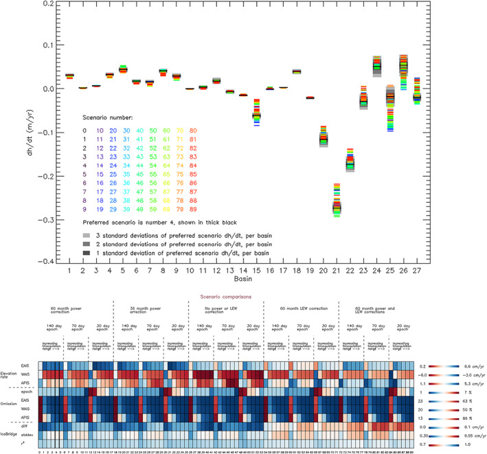
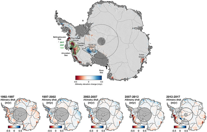
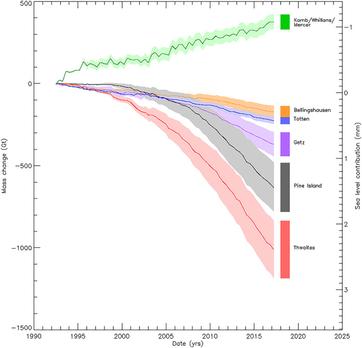
Fluctuations in Antarctic Ice Sheet elevation and mass occur over a variety of time scales, owing to changes in snowfall and ice flow. Here we disentangle these signals by combining 25 years of satellite radar altimeter observations and a regional climate model. From these measurements, patterns of change that are strongly associated with glaciological events emerge. While the majority of the ice sheet has remained stable, 24% of West Antarctica is now in a state of dynamical imbalance. Thinning of the Pine Island and Thwaites glacier basins reaches 122 m in places, and their rates of ice loss are now five times greater than at the start of our survey. By partitioning elevation changes into areas of snow and ice variability, we estimate that East and West Antarctica have contributed -1.1 ± 0.4 and +5.7 ± 0.8 mm to global sea level between 1992 and 2017.
Keywords: Antarctica; altimetry; climate; imbalance; satellite; sea level.
©2019. The Authors.
Figures
References
-
- Anandakrishnan, S. , & Alley, R. B. (1997). Stagnation of Ice Stream C, West Antarctica by water piracy. Geophysical Research Letters, 24(3), 265–268. 10.1029/96GL04016 - DOI
-
- Boening, C. , Lebsock, M. , Landerer, F. , & Stephens, G. (2012). Snowfall‐driven mass change on the East Antarctic ice sheet. Geophysical Research Letters, 39, L21501. 10.1029/2012GL053316 - DOI
-
- Bouman, J. , Fuchs, M. , Ivins, E. , Van Der Wal, W. , Schrama, E. , Visser, P. , & Horwath, M. (2014). Antarctic outlet glacier mass change resolved at basin scale from satellite gravity gradiometry. Geophysical Research Letters, 41, 5919–5926. 10.1002/2014GL060637 - DOI
-
- Bromwich, D. H. , Nicolas, J. P. , & Monaghan, A. J. (2011). An Assessment of precipitation changes over Antarctica and the Southern Ocean since 1989 in contemporary global reanalyses. Journal of Climate, 24(16), 4189–4209. 10.1175/2011JCLI4074.1 - DOI
-
- Christie, F. D. W. , Bingham, R. G. , Gourmelen, N. , Tett, S. F. B. , & Muto, A. (2016). Four‐decade record of pervasive grounding line retreat along the Bellingshausen margin of West Antarctica. Geophysical Research Letters, 43, 5741–5749. 10.1002/2016GL068972 - DOI
Reference From the Supporting Information
-
- Arthern, R. J. , & Wingham, D. J. (1998). The natural fluctuations of firn densification and their effect on the geodetic determination of ice sheet mass balance. Climatic Change, 40(3/4), 605–624. 10.1023/A:1005320713306 - DOI
LinkOut - more resources
Full Text Sources