

Deep Learning-Based Automatic Detection of Ships: An Experimental Study Using Satellite Images
- PMID: 35877626
- PMCID: PMC9325223
- DOI: 10.3390/jimaging8070182
Deep Learning-Based Automatic Detection of Ships: An Experimental Study Using Satellite Images
Abstract
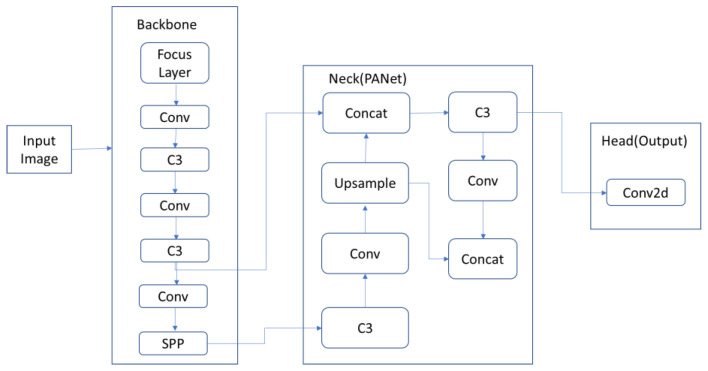
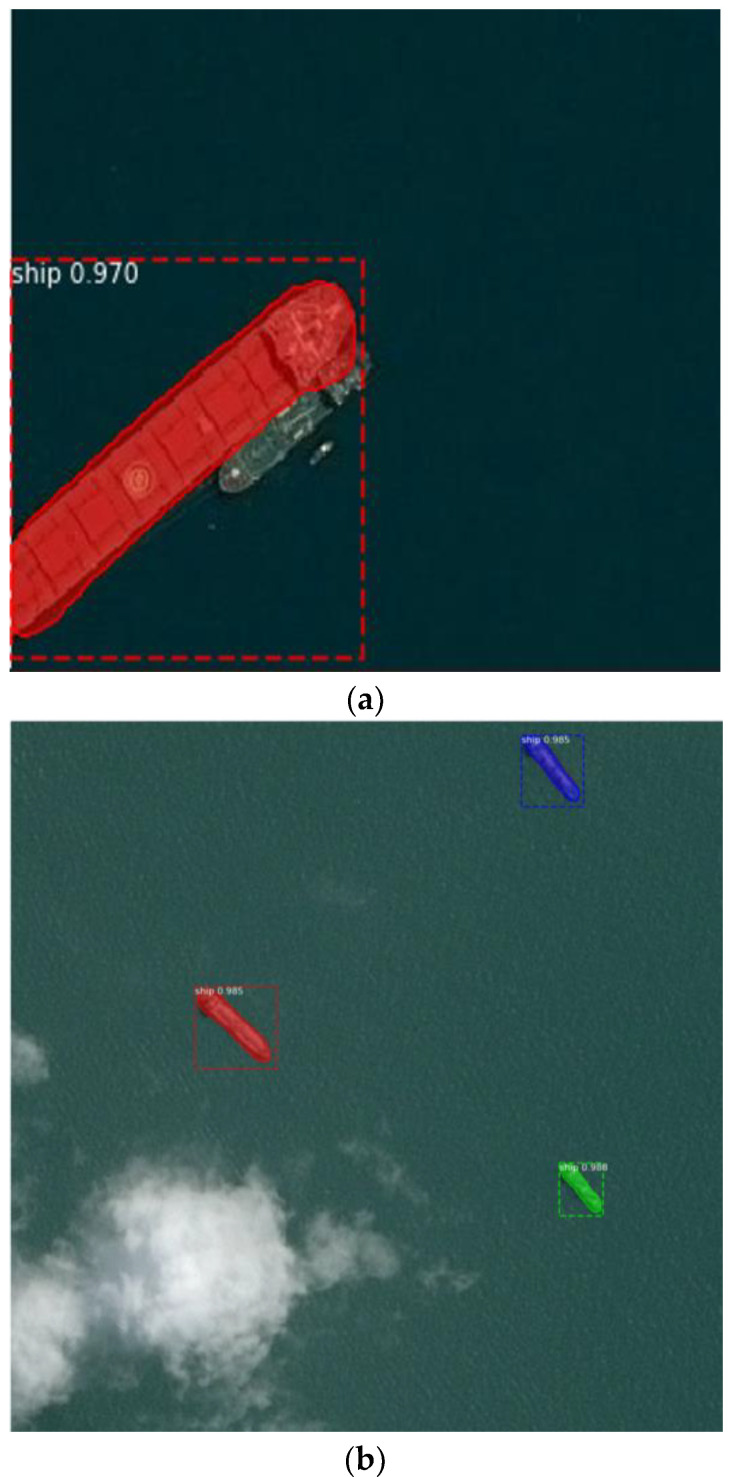
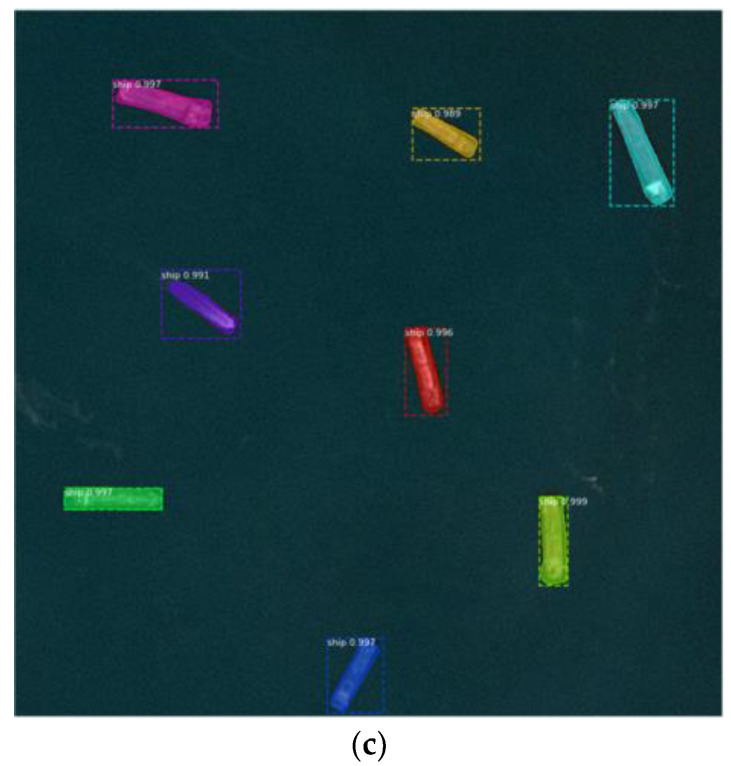
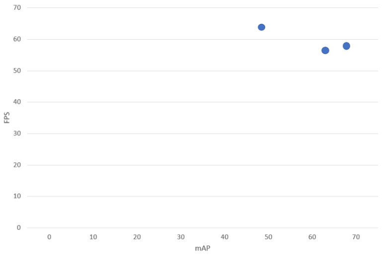
The remote sensing surveillance of maritime areas represents an essential task for both security and environmental reasons. Recently, learning strategies belonging to the field of machine learning (ML) have become a niche of interest for the community of remote sensing. Specifically, a major challenge is the automatic classification of ships from satellite imagery, which is needed for traffic surveillance systems, the protection of illegal fisheries, control systems of oil discharge, and the monitoring of sea pollution. Deep learning (DL) is a branch of ML that has emerged in the last few years as a result of advancements in digital technology and data availability. DL has shown capacity and efficacy in tackling difficult learning tasks that were previously intractable. Specifically, DL methods, such as convolutional neural networks (CNNs), have been reported to be efficient in image detection and recognition applications. In this paper, we focused on the development of an automatic ship detection (ASD) approach by using DL methods for assessing the Airbus ship dataset (composed of about 40 K satellite images). The paper explores and analyzes the distinct variations of the YOLO algorithm for the detection of ships from satellite images. A comparison of different versions of YOLO algorithms for ship detection, such as YOLOv3, YOLOv4, and YOLOv5, is presented, after training them on a personal computer with a large dataset of satellite images of the Airbus Ship Challenge and Shipsnet. The differences between the algorithms could be observed on the personal computer. We have confirmed that these algorithms can be used for effective ship detection from satellite images. The conclusion drawn from the conducted research is that the YOLOv5 object detection algorithm outperforms the other versions of the YOLO algorithm, i.e., YOLOv4 and YOLOv3 in terms accuracy of 99% for YOLOv5 compared to 98% and 97% respectively for YOLOv4 and YOLOv3.
Keywords: convolutional neural networks; deep learning; image classification; remote sensing; satellite images; ships detection; surveillance.
Conflict of interest statement
The authors declare no conflict of interest.
Figures
Similar articles
-
Edge computing for detection of ship and ship port from remote sensing images using YOLO.Front Artif Intell. 2025 Feb 6;8:1508664. doi: 10.3389/frai.2025.1508664. eCollection 2025. Front Artif Intell. 2025. PMID: 39981193 Free PMC article.
-
Literature Review on Ship Localization, Classification, and Detection Methods Based on Optical Sensors and Neural Networks.Sensors (Basel). 2022 Sep 12;22(18):6879. doi: 10.3390/s22186879. Sensors (Basel). 2022. PMID: 36146228 Free PMC article. Review.
-
Automatic Target Detection from Satellite Imagery Using Machine Learning.Sensors (Basel). 2022 Feb 2;22(3):1147. doi: 10.3390/s22031147. Sensors (Basel). 2022. PMID: 35161892 Free PMC article.
-
Nature-Inspired Search Method and Custom Waste Object Detection and Classification Model for Smart Waste Bin.Sensors (Basel). 2022 Aug 18;22(16):6176. doi: 10.3390/s22166176. Sensors (Basel). 2022. PMID: 36015936 Free PMC article.
-
Recent Advances in Deep Learning-Based Spatiotemporal Fusion Methods for Remote Sensing Images.Sensors (Basel). 2025 Feb 12;25(4):1093. doi: 10.3390/s25041093. Sensors (Basel). 2025. PMID: 40006322 Free PMC article. Review.
Cited by
-
Edge computing for detection of ship and ship port from remote sensing images using YOLO.Front Artif Intell. 2025 Feb 6;8:1508664. doi: 10.3389/frai.2025.1508664. eCollection 2025. Front Artif Intell. 2025. PMID: 39981193 Free PMC article.
-
State-of-the-Art Deep Learning Methods for Objects Detection in Remote Sensing Satellite Images.Sensors (Basel). 2023 Jun 23;23(13):5849. doi: 10.3390/s23135849. Sensors (Basel). 2023. PMID: 37447699 Free PMC article.
-
Image-Based Ship Detection Using Deep Variational Information Bottleneck.Sensors (Basel). 2023 Sep 26;23(19):8093. doi: 10.3390/s23198093. Sensors (Basel). 2023. PMID: 37836922 Free PMC article.
-
Tea leaf disease detection and identification based on YOLOv7 (YOLO-T).Sci Rep. 2023 Apr 13;13(1):6078. doi: 10.1038/s41598-023-33270-4. Sci Rep. 2023. PMID: 37055480 Free PMC article.
-
Literature Review on Ship Localization, Classification, and Detection Methods Based on Optical Sensors and Neural Networks.Sensors (Basel). 2022 Sep 12;22(18):6879. doi: 10.3390/s22186879. Sensors (Basel). 2022. PMID: 36146228 Free PMC article. Review.
References
-
- Alzubaidi L., Zhang J., Humaidi A.J., Al-Dujaili A., Duan Y., Al-Shamma O., Santamaría J., Fadhel M.A., Al-Amidie M., Farhan L. Review of deep learning: Concepts, CNN architectures, challenges, applications, future directions. J. Big Data. 2021;8:1–74. doi: 10.1186/s40537-021-00444-8. - DOI - PMC - PubMed
-
- Nascimento R.G.D., Viana F. Satellite Image Classification and Segmentation with Transfer Learning; Proceedings of the AIAA Scitech 2020 Forum; Orlando, FL, USA. 6–10 January 2020; p. 1864.
-
- Stofa M.M., Zulkifley M.A., Zaki S.Z.M. A deep learning approach to ship detection using satellite imagery. IOP Conf. Ser. Earth Environ. Sci. 2020;540:012049. doi: 10.1088/1755-1315/540/1/012049. - DOI
-
- Zhang R., Li S., Ji G., Zhao X., Li J., Pan M. Survey on Deep Learning-Based Marine Object Detection. J. Adv. Transp. 2021;2021:5808206. doi: 10.1155/2021/5808206. - DOI
-
- Avolio C., Zavagli M., Paterino G., Paola N., Costantini M. A Near Real Time CFAR Approach for Ship Detection on Sar Data Based on a Generalized-K Distributed Clutter Estimation; Proceedings of the 2021 IEEE International Geoscience and Remote Sensing Symposium IGARSS; Brussels, Belgium. 11–16 July 2021; pp. 224–227.
LinkOut - more resources
Full Text Sources
