

Determining the spatial distribution of environmental and socio-economic suitability for human leptospirosis in the face of limited epidemiological data
- PMID: 35927739
- PMCID: PMC9351081
- DOI: 10.1186/s40249-022-01010-x
Determining the spatial distribution of environmental and socio-economic suitability for human leptospirosis in the face of limited epidemiological data
Abstract
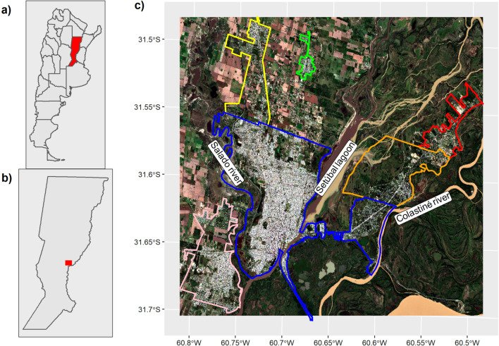
Background: Leptospirosis is among the leading zoonotic causes of morbidity and mortality worldwide. Knowledge about spatial patterns of diseases and their underlying processes have the potential to guide intervention efforts. However, leptospirosis is often an underreported and misdiagnosed disease and consequently, spatial patterns of the disease remain unclear. In the absence of accurate epidemiological data in the urban agglomeration of Santa Fe, we used a knowledge-based index and cluster analysis to identify spatial patterns of environmental and socioeconomic suitability for the disease and potential underlying processes that shape them.
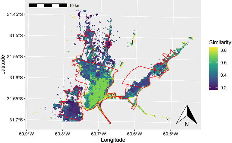
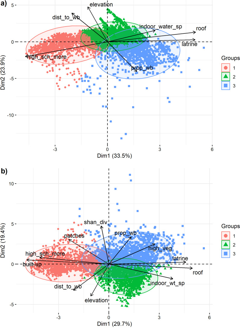
Methods: We geocoded human leptospirosis cases derived from the Argentinian surveillance system during the period 2010 to 2019. Environmental and socioeconomic databases were obtained from satellite images and publicly available platforms on the web. Two sets of human leptospirosis determinants were considered according to the level of their support by the literature and expert knowledge. We used the Zonation algorithm to build a knowledge-based index and a clustering approach to identify distinct potential sets of determinants. Spatial similarity and correlations between index, clusters, and incidence rates were evaluated.
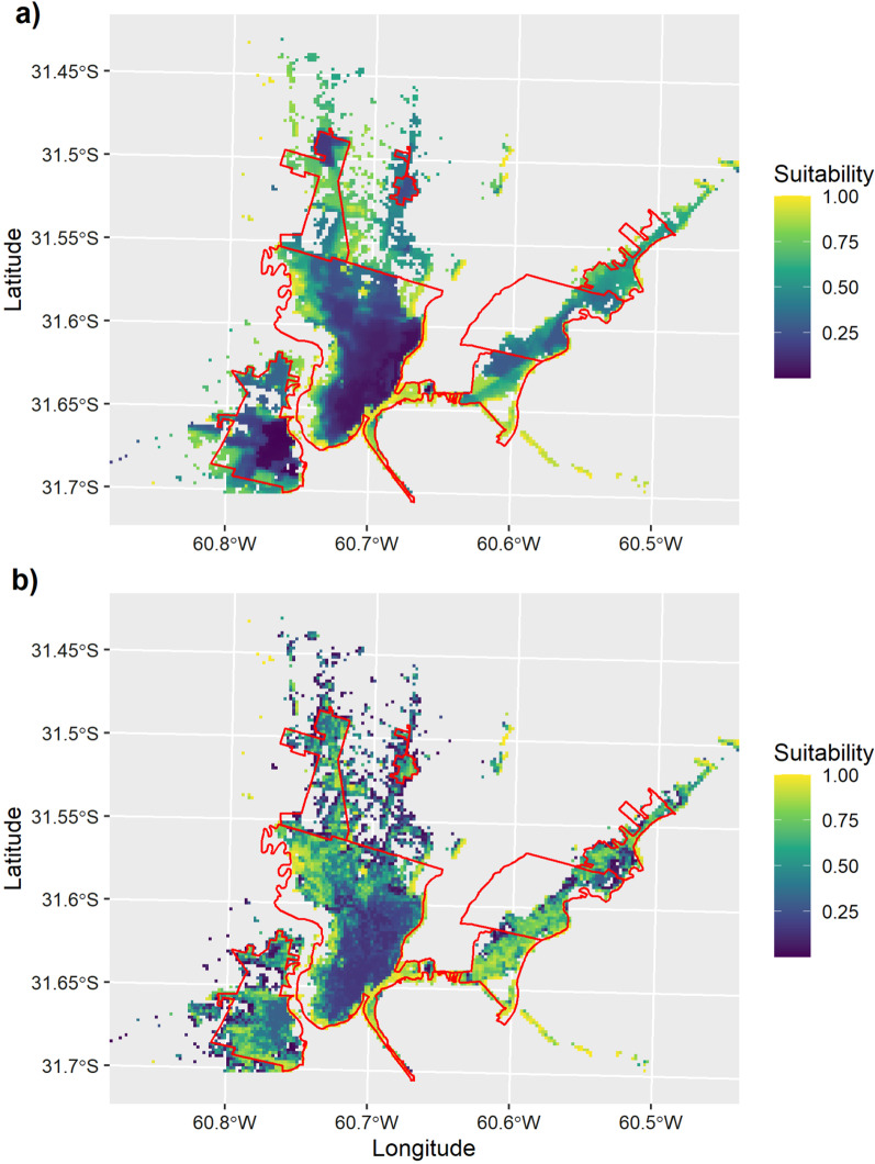
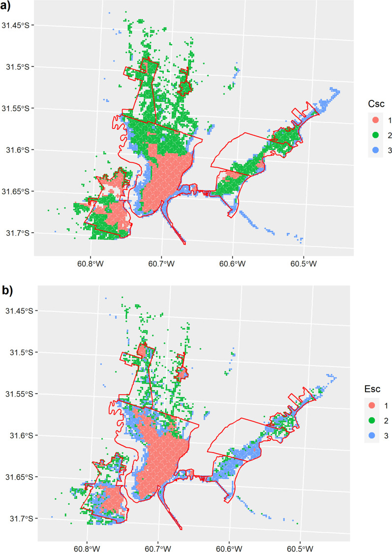
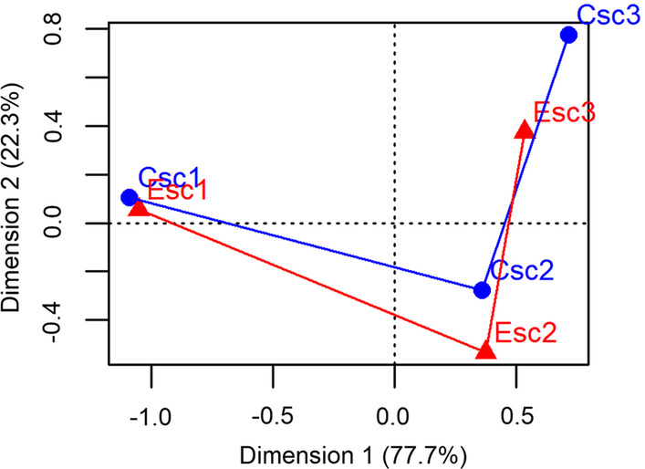
Results: We were able to geocode 56.36% of the human leptospirosis cases reported in the national epidemiological database. The knowledge-based index showed the suitability for human leptospirosis in the UA Santa Fe increased from downtown areas of the largest cities towards peri-urban and suburban areas. Cluster analysis revealed downtown areas were characterized by higher levels of socioeconomic conditions. Peri-urban and suburban areas encompassed two clusters which differed in terms of environmental determinants. The highest incidence rates overlapped areas with the highest suitability scores, the strength of association was low though (CSc r = 0.21, P < 0.001 and ESc r = 0.19, P < 0.001).
Conclusions: We present a method to analyze the environmental and socioeconomic suitability for human leptospirosis based on literature and expert knowledge. The methodology can be thought as an evolutive and perfectible scheme as more studies are performed in the area and novel information regarding determinants of the disease become available. Our approach can be a valuable tool for decision-makers since it can serve as a baseline to plan intervention measures.
Keywords: Cluster analysis; Environmental conditions; Knowledge-based index; Socioeconomic groups; Spatial epidemiology; Underreported misdiagnosed diseases.
© 2022. The Author(s).
Conflict of interest statement
The authors declare that they have no competing interests.
Figures
Similar articles
-
Spatial epidemiological approaches to inform leptospirosis surveillance and control: A systematic review and critical appraisal of methods.Zoonoses Public Health. 2019 Mar;66(2):185-206. doi: 10.1111/zph.12549. Epub 2018 Dec 28. Zoonoses Public Health. 2019. PMID: 30593736
-
Spatiotemporal clustering, social inequities and the risk of leptospirosis in an endemic area of Brazil: a retrospective spatial modelling.Trans R Soc Trop Med Hyg. 2021 Aug 2;115(8):854-862. doi: 10.1093/trstmh/traa128. Trans R Soc Trop Med Hyg. 2021. PMID: 33205148
-
[Spatial distribution of leptospirosis in the city of Rio de Janeiro, Brazil, 1996-1999].Cad Saude Publica. 2004 Nov-Dec;20(6):1721-9. doi: 10.1590/s0102-311x2004000600031. Epub 2004 Dec 8. Cad Saude Publica. 2004. PMID: 15608875 Portuguese.
-
Mapping risk of leptospirosis in China using environmental and socioeconomic data.BMC Infect Dis. 2016 Jul 22;16:343. doi: 10.1186/s12879-016-1653-5. BMC Infect Dis. 2016. PMID: 27448599 Free PMC article.
-
Geoprocessing and spatial analysis for identifying leptospirosis risk areas: a systematic review.Rev Inst Med Trop Sao Paulo. 2020 Jun 5;62:e35. doi: 10.1590/S1678-9946202062035. eCollection 2020. Rev Inst Med Trop Sao Paulo. 2020. PMID: 32520210 Free PMC article.
Cited by
-
Geospatial Analysis of Abiotic and Biotic Conditions Associated with Leptospirosis in the Klaten Regency, Central Java, Indonesia.Trop Med Infect Dis. 2024 Sep 24;9(10):225. doi: 10.3390/tropicalmed9100225. Trop Med Infect Dis. 2024. PMID: 39453252 Free PMC article.
-
Towards a leptospirosis early warning system in northeastern Argentina.J R Soc Interface. 2023 May;20(202):20230069. doi: 10.1098/rsif.2023.0069. Epub 2023 May 17. J R Soc Interface. 2023. PMID: 37194269 Free PMC article.
-
Geospatial analysis of leptospirosis clusters and risk factors in two provinces of the Dominican Republic.PLoS Negl Trop Dis. 2025 Jun 11;19(6):e0013103. doi: 10.1371/journal.pntd.0013103. eCollection 2025 Jun. PLoS Negl Trop Dis. 2025. PMID: 40498763 Free PMC article.
References
MeSH terms
Grants and funding
LinkOut - more resources
Full Text Sources
