

Dual-Coupled CNN-GCN-Based Classification for Hyperspectral and LiDAR Data
- PMID: 35957291
- PMCID: PMC9371133
- DOI: 10.3390/s22155735
Dual-Coupled CNN-GCN-Based Classification for Hyperspectral and LiDAR Data
Abstract
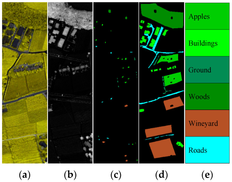
Deep learning techniques have brought substantial performance gains to remote sensing image classification. Among them, convolutional neural networks (CNN) can extract rich spatial and spectral features from hyperspectral images in a short-range region, whereas graph convolutional networks (GCN) can model middle- and long-range spatial relations (or structural features) between samples on their graph structure. These different features make it possible to classify remote sensing images finely. In addition, hyperspectral images and light detection and ranging (LiDAR) images can provide spatial-spectral information and elevation information of targets on the Earth's surface, respectively. These multi-source remote sensing data can further improve classification accuracy in complex scenes. This paper proposes a classification method for HS and LiDAR data based on a dual-coupled CNN-GCN structure. The model can be divided into a coupled CNN and a coupled GCN. The former employs a weight-sharing mechanism to structurally fuse and simplify the dual CNN models and extracting the spatial features from HS and LiDAR data. The latter first concatenates the HS and LiDAR data to construct a uniform graph structure. Then, the dual GCN models perform structural fusion by sharing the graph structures and weight matrices of some layers to extract their structural information, respectively. Finally, the final hybrid features are fed into a standard classifier for the pixel-level classification task under a unified feature fusion module. Extensive experiments on two real-world hyperspectral and LiDAR data demonstrate the effectiveness and superiority of the proposed method compared to other state-of-the-art baseline methods, such as two-branch CNN and context CNN. In particular, the overall accuracy (99.11%) on Trento achieves the best classification performance reported so far.
Keywords: convolutional neural network; graph convolutional network; hyperspectral; light detection and ranging.
Conflict of interest statement
The authors declare no conflict of interest.
Figures


Similar articles
-
A Dual-Branch Fusion of a Graph Convolutional Network and a Convolutional Neural Network for Hyperspectral Image Classification.Sensors (Basel). 2024 Jul 22;24(14):4760. doi: 10.3390/s24144760. Sensors (Basel). 2024. PMID: 39066156 Free PMC article.
-
Multi-source remote sensing image classification based on two-channel densely connected convolutional networks.Math Biosci Eng. 2020 Oct 27;17(6):7353-7377. doi: 10.3934/mbe.2020376. Math Biosci Eng. 2020. PMID: 33378900
-
Fusion of Hyperspectral CASI and Airborne LiDAR Data for Ground Object Classification through Residual Network.Sensors (Basel). 2020 Jul 16;20(14):3961. doi: 10.3390/s20143961. Sensors (Basel). 2020. PMID: 32708693 Free PMC article.
-
Deep Learning for LiDAR Point Cloud Classification in Remote Sensing.Sensors (Basel). 2022 Oct 16;22(20):7868. doi: 10.3390/s22207868. Sensors (Basel). 2022. PMID: 36298220 Free PMC article. Review.
-
Deep Learning for Human Activity Recognition on 3D Human Skeleton: Survey and Comparative Study.Sensors (Basel). 2023 May 27;23(11):5121. doi: 10.3390/s23115121. Sensors (Basel). 2023. PMID: 37299848 Free PMC article. Review.
Cited by
-
Mutual Information-Driven Feature Reduction for Hyperspectral Image Classification.Sensors (Basel). 2023 Jan 6;23(2):657. doi: 10.3390/s23020657. Sensors (Basel). 2023. PMID: 36679453 Free PMC article.
-
Hypergraph Convolution Network Classification for Hyperspectral and LiDAR Data.Sensors (Basel). 2025 May 14;25(10):3092. doi: 10.3390/s25103092. Sensors (Basel). 2025. PMID: 40431884 Free PMC article.
References
-
- Huang R., Hong D., Xu Y., Yao W., Stilla U. Multi-Scale Local Context Embedding for LiDAR Point Cloud Classification. IEEE Geosci. Remote Sens. Lett. 2020;17:721–725. doi: 10.1109/LGRS.2019.2927779. - DOI
-
- Hang R., Liu Q., Hong D., Ghamisi P. Cascaded Recurrent Neural Networks for Hyperspectral Image Classification. IEEE Trans. Geosci. Remote Sens. 2019;57:5384–5394. doi: 10.1109/TGRS.2019.2899129. - DOI
-
- Yokoya N., Grohnfeldt C., Chanussot J. Hyperspectral and Multispectral Data Fusion: A Comparative Review of the Recent Literature. IEEE Geosci. Remote Sens. Mag. 2017;5:29–56. doi: 10.1109/MGRS.2016.2637824. - DOI
-
- Ghamisi P., Gloaguen R., Atkinson P.M., Benediktsson J.A., Rasti B., Yokoya N., Wang Q., Hofle B., Bruzzone L., Bovolo F., et al. Multisource and Multitemporal Data Fusion in Remote Sensing: A Comprehensive Review of the State of the Art. IEEE Geosci. Remote Sens. Mag. 2019;7:6–39. doi: 10.1109/MGRS.2018.2890023. - DOI
MeSH terms
LinkOut - more resources
Full Text Sources
Other Literature Sources
