. 2022 Aug 12;12(1):13731.
doi: 10.1038/s41598-022-16743-w.

Overall negative trends for snow cover extent and duration in global mountain regions over 1982-2020

Affiliations

Overall negative trends for snow cover extent and duration in global mountain regions over 1982-2020

C Notarnicola. Sci Rep. .

Abstract

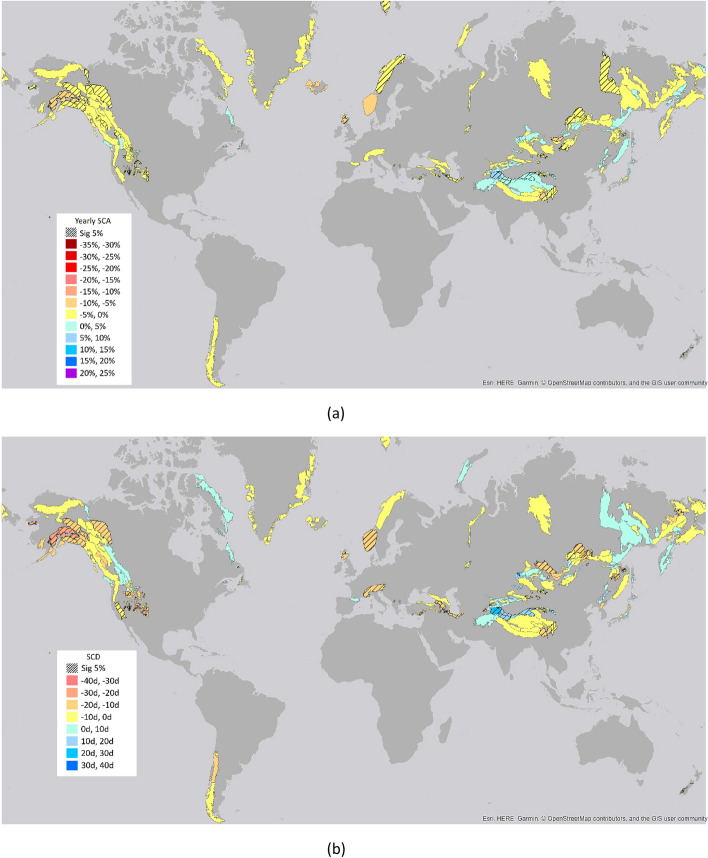
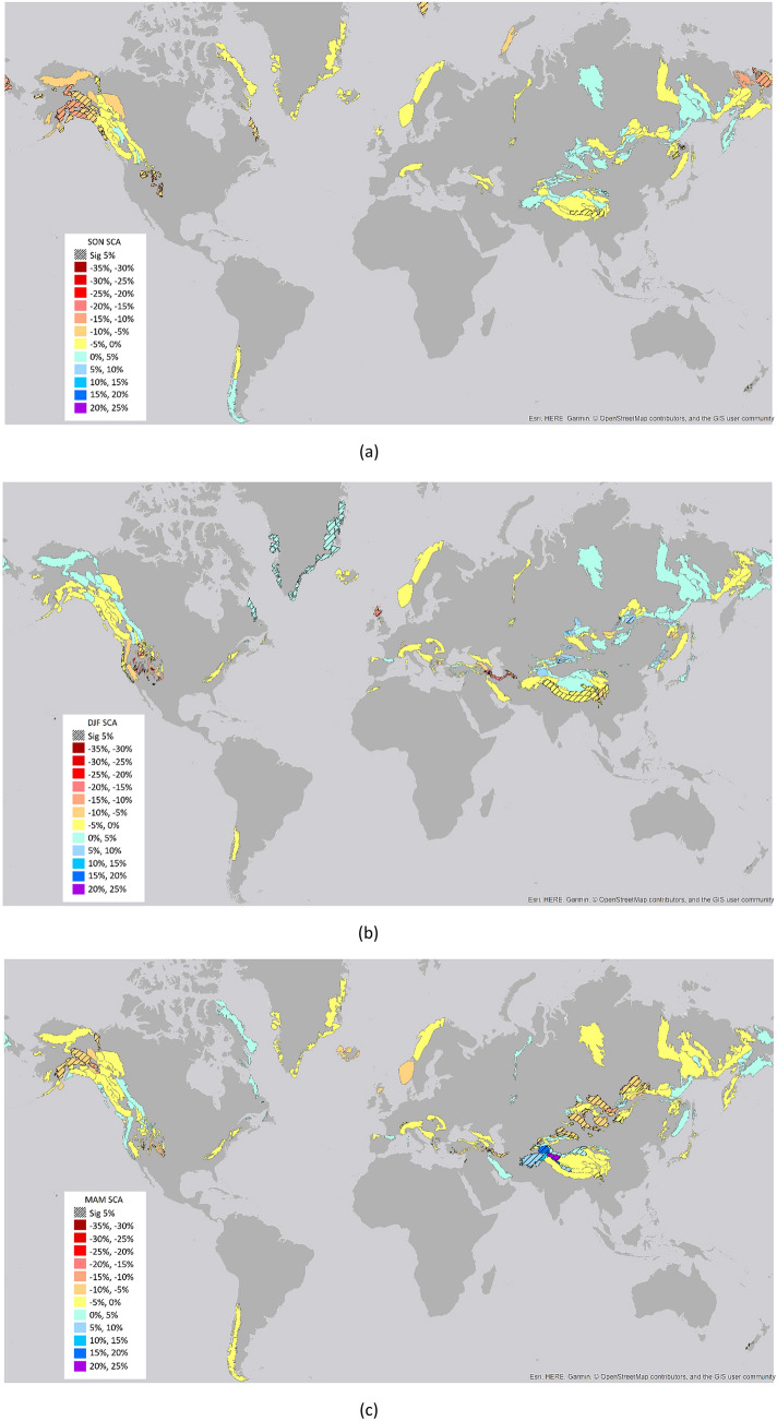
Notwithstanding the large availability of data and models, a consistent picture of the snow cover extent and duration changes in global mountain areas is lacking for long-term trends. Here, model data and satellite images are combined by using Artificial Neural Networks to generate a consistent time series from 1982 to 2020 over global mountain areas. The analysis of the harmonized time series over 38 years indicates an overall negative trend of - 3.6% ± 2.7% for yearly snow cover extent and of - 15.1 days ± 11.6 days for snow cover duration. The most affected season by negative trends is winter with an average reduction in snow cover extent of - 11.5% ± 6.9%, and the most affected season by positive changes is spring with an average increase of 10% ± 5.9%, the latter mainly located in High Mountain Asia. The results indicated a shift in the snow regime located between the 80 s and 90 s of the previous century, where the period from 1982 to 1999 is characterized by a higher number of areas with significant changes and a higher rate of changes with respect to the period 2000-2020. This quantification can lead to a more accurate evaluation of the impact on water resources for mountainous communities.


Conflict of interest statement

The author declares no competing interests.

Figures

Figure 1
Figure 1
Global trends over 1982–2020 for (a) SCA and (b) SCD parameters. The figure shows the results of the Mann–Kendall statistics over mountain areas. The underlined areas show significant trends at 5% level (the maps were created by the author using the software ARCGIS v.10.1, www.esri.com).
Figure 2
Figure 2
Global trends over 1982–2020 for SCA values in the different seasons: (a) September–October–November (SON), (b) December–January–February (DJF), (c) March–April–May (MAM), (d) June–July–August (JJA). The underlined areas show significant trends at 5% level (the maps were created by the author using the software ARCGIS v.10.1, www.esri.com).
Figure 2
Figure 2
Global trends over 1982–2020 for SCA values in the different seasons: (a) September–October–November (SON), (b) December–January–February (DJF), (c) March–April–May (MAM), (d) June–July–August (JJA). The underlined areas show significant trends at 5% level (the maps were created by the author using the software ARCGIS v.10.1, www.esri.com).
Figure 3
Figure 3
Percentage of areas with significant trends. Percentage of areas with respect to the total number of areas with significant positive and negative trends for the long-term period (1982–2020) and the three sub-periods analyzed (1982–2000, 1990–2010, 2000–2020).
Figure 4
Figure 4
Average magnitude of positive and negative changes for (a) SCA at year level and in different seasons, (b) for SCD. The average is calculated over the areas with a significant trend at 5% level.
Figure 5
Figure 5
Distributions of the areas (in % with respect to the total number of areas) for trends in different periods. In the legend, the digit of thousands indicates significant trends in 1982–2020, the digit of hundreds in 1982–2000, the digit of tens in 1990–2010, the single digit in 2000–2020. The value “2” indicates negative significant trends and the value “1” represents positive significant trends. For example: “0002” indicates a negative trend for the last period 2000–2020 and no significant trends in the other analyzed period. “2000” indicates a negative significant trend for the period 1982–2020 and no significant trends in the other analyzed periods. The colors in the figure are the same of Figs. S1 and S2.
Figure 6
Figure 6
Flowchart of the overall procedure. It is shown the case where the target variable is the yearly SCA. The same applies for the other considered target variables that is SCD, SON SCA, DJF SCA, MAM SCA, JJA SCA.

References

    1. Frei A, Robinson DA. Northern Hemisphere snow extent: Regional variability 1972 to 1994. Int. J. Climatol. 1999;19:1535–1560. doi: 10.1002/(SICI)1097-0088(19991130)19:14<1535::AID-JOC438>3.0.CO;2-J. - DOI
    1. Frei A, Robinson DA, Hughes MG. North American snow extent: 1900–1994. Int. J. Climatol. 1999;19:1517–1534. doi: 10.1002/(SICI)1097-0088(19991130)19:14<1517::AID-JOC437>3.0.CO;2-I. - DOI
    1. Brown RD. Northern Hemisphere snow-cover variability and change 1915–1997. J. Clim. 2000;13:2339–2355. doi: 10.1175/1520-0442(2000)013<2339:NHSCVA>2.0.CO;2. - DOI
    1. Räisänen J. Warmer climate: Less or more snow? Clim. Dyn. 2008;30:307–319. doi: 10.1007/s00382-007-0289-y. - DOI
    1. Li W, Guo W, Qiu B, Xue Y, Hsu P, Wei J. Influence of Tibetan Plateau snow cover on East Asian atmospheric circulation at medium-range time scales. Nat. Commun. 2018;9:4243. doi: 10.1038/s41467-018-06762-5. - DOI - PMC - PubMed