

doi: 10.1007/s11111-020-00372-4.
Epub 2021 Mar 24.
Working toward effective anonymization for surveillance data: innovation at South Africa's Agincourt Health and Socio-Demographic Surveillance Site
Affiliations
- PMID: 35966940
- PMCID: PMC9374160
- DOI: 10.1007/s11111-020-00372-4
Item in Clipboard
Working toward effective anonymization for surveillance data: innovation at South Africa's Agincourt Health and Socio-Demographic Surveillance Site
Popul Environ.
2021 Jun.
No abstract available
Figures

A Conceptual Illustration of Geographic Masking (Zanderbergen 2014)

Example of a Simple Random Offset for 2 Households

* black circle represents the original location; gray dots represent 700
simulated possible locations using each masking method within a radius of 300m
with exclusion zones of 150 m for scenarios 3 and 4.

Villages within the MRC/Wits Agincourt Health Demographic Surveillance
Site, South Africa

*Diamonds represent NDVI values during growing season months (September
to April)
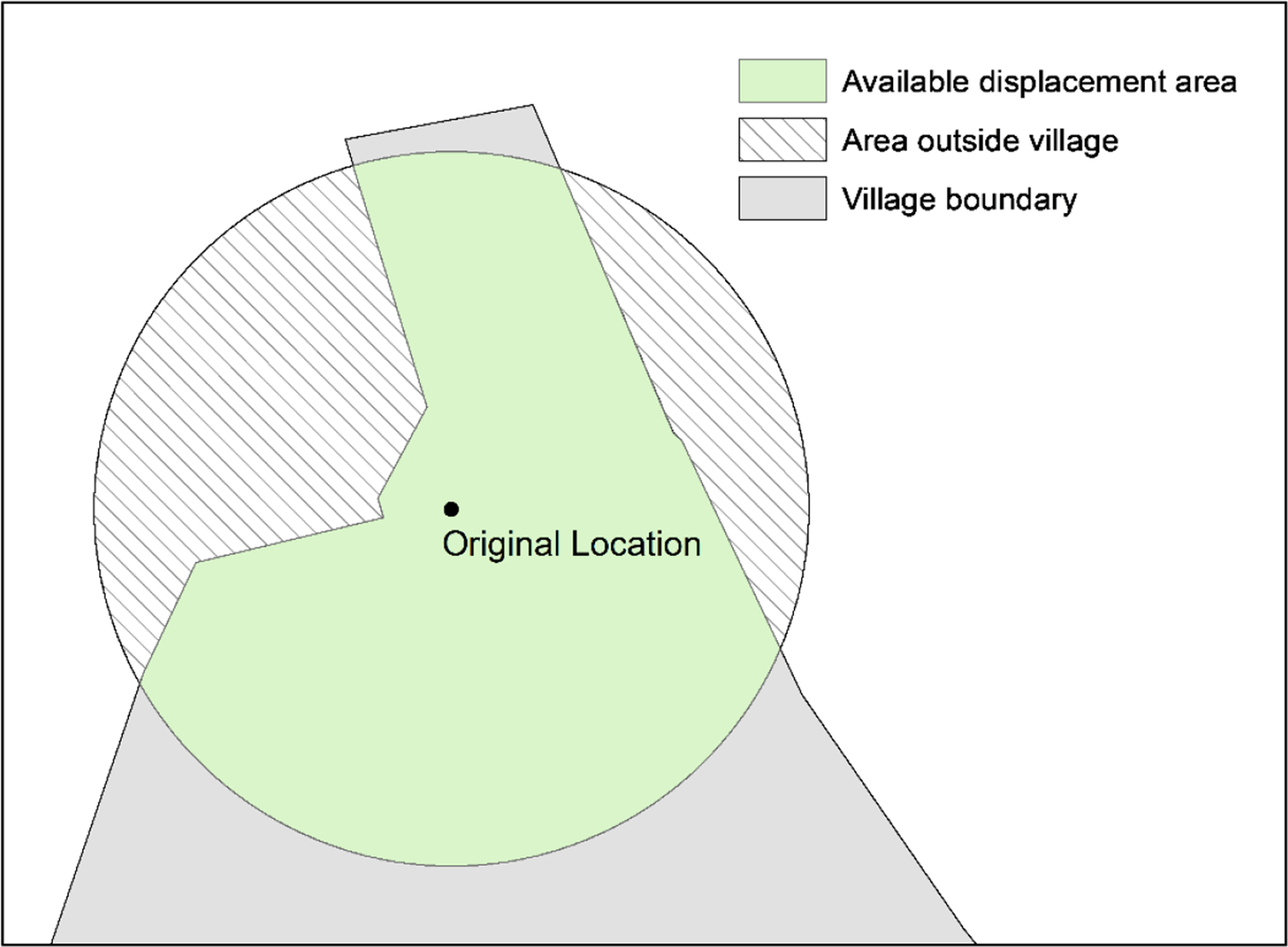
Random Geomasking within a Buffer Constrained by Village Boundaries

Three Geomasking Techniques with Randomization within Boundaries,
MRC/Wits Agincourt-Unit

NDVI Values (Jan 2010) for True Household Locations, 2 km buffers,
MRC/Wits Agincourt-Unit

*Blue = NDVI for true households; Green = NDVI for geomasked household
(displaced randomly within village).

Spatial Distribution of Difference in Sum of NDVI Values/ Number of
Households, True vs. Geomasked Locations, MRC/Wits Agincourt-Unit
Similar articles
-
The Agincourt field site--evolution and current status.S Afr Med J. 1999 Aug;89(8):853-8. S Afr Med J. 1999. PMID: 10488361
-
Two decades of mortality change in rural northeast South Africa.Glob Health Action. 2014 Oct 29;7:25596. doi: 10.3402/gha.v7.25596. eCollection 2014. Glob Health Action. 2014. PMID: 25377343 Free PMC article.
-
Mental health nurses in South Africa's public rural primary care settings: a human resource crisis.Rural Remote Health. 2016 Jul-Sep;16(3):3865. Epub 2016 Jul 18. Rural Remote Health. 2016. PMID: 27430669
-
Recommendations for the management of indeterminate HIV PCR results within South Africa's early infant diagnosis programme.South Afr J HIV Med. 2016 May 13;17(1):451. doi: 10.4102/sajhivmed.v17i1.451. eCollection 2016. South Afr J HIV Med. 2016. PMID: 29568610 Free PMC article. Review.
-
Africa's contribution to global sustainable and healthy diets: a scoping review.Front Nutr. 2025 May 2;12:1519248. doi: 10.3389/fnut.2025.1519248. eCollection 2025. Front Nutr. 2025. PMID: 40386220 Free PMC article. Review.
Cited by
-
Population Responses to Environmental Change: Looking Back, Looking Forward.Popul Environ. 2021 Jun;42(4):431-444. doi: 10.1007/s11111-021-00382-w. Epub 2021 Mar 23. Popul Environ. 2021. PMID: 34149137 Free PMC article.
References
-
- Anane-Sarpong Evelyn, et al. (2016) “Application of Ethical Principles to Research using Public Health Data in The Global South: Perspectives from Africa.” Developing world bioethics. - PubMed
-
- Arbia G, Espa G, & Giuliani D (2015). Measurement errors arising when using distances in microeconometric modelling and the individuals’ position is geo-masked for confidentiality. Econometrics, 3(4), 709–718.
-
- Armstrong Marc P., Rushton Gerard, and Zimmerman Dale L.. (1999). “Geographically Masking Health Data to Preserve Confidentiality.” Statistics in Medicine 18(5):497–525. - PubMed
-
- Byers E, Gidden M, Leclère D, Balkovic J, Burek P, Ebi K, … & Johnson N (2018). Global exposure and vulnerability to multi-sector development and climate change hotspots. Environmental Research Letters, 13(5), 055012.
Grants and funding
LinkOut - more resources
Full Text Sources