. 2022 Sep;609(7925):83-88.
doi: 10.1038/s41586-022-05047-8. Epub 2022 Aug 31.

Precursor-free eruption triggered by edifice rupture at Nyiragongo volcano

Affiliations

Precursor-free eruption triggered by edifice rupture at Nyiragongo volcano

D Smittarello et al. Nature. 2022 Sep.

Abstract

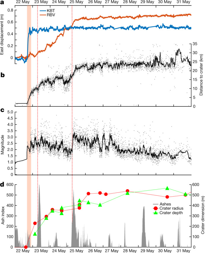
Classical mechanisms of volcanic eruptions mostly involve pressure buildup and magma ascent towards the surface1. Such processes produce geophysical and geochemical signals that may be detected and interpreted as eruption precursors1-3. On 22 May 2021, Mount Nyiragongo (Democratic Republic of the Congo), an open-vent volcano with a persistent lava lake perched within its summit crater, shook up this interpretation by producing an approximately six-hour-long flank eruption without apparent precursors, followed-rather than preceded-by lateral magma motion into the crust. Here we show that this reversed sequence was most likely initiated by a rupture of the edifice, producing deadly lava flows and triggering a voluminous 25-km-long dyke intrusion. The dyke propagated southwards at very shallow depth (less than 500 m) underneath the cities of Goma (Democratic Republic of the Congo) and Gisenyi (Rwanda), as well as Lake Kivu. This volcanic crisis raises new questions about the mechanisms controlling such eruptions and the possibility of facing substantially more hazardous events, such as effusions within densely urbanized areas, phreato-magmatism or a limnic eruption from the gas-rich Lake Kivu. It also more generally highlights the challenges faced with open-vent volcanoes for monitoring, early detection and risk management when a significant volume of magma is stored close to the surface.


Conflict of interest statement

The authors declare no competing interests.

Figures

Fig. 1
Fig. 1. Co-eruptive geodetic signals and seismicity.
a, Situation map. b,c, Sentinel-1 (S1) 19 May 2021 to 31 May 2021 ascending (A) interferogram overlaid with automatic earthquake locations and GNSS displacements (disp.) over time (blue to black colours with time from the onset of the eruption), eruptive fissures (yellow lines 1 to 6, from north to south), ground fissures detected from interferogram discontinuities (grey lines), lava flows (red area) and seismic and GNSS stations from KivuSNet and KivuGNet available during the crisis (black and green triangles, respectively). DRC, Democratic Republic of the Congo; Nyam., Nyamulagira; Rw., Rwanda; Ug., Uganda. Panel c shows a magnification of the central box in b. d, North–south transect of hypocentral depth (same symbols as in b and c). Coordinates are given in kilometres in the WGS 1984 UTM (Zone 35S) system. Source data
Fig. 2
Fig. 2. Time series of co- and post-eruptive signals.
a, Eastward displacement recorded at KBT (blue) and RBV (orange) GNSS stations. b,c, Distance to crater (b) and magnitude (c) of automatically located earthquakes (grey dots) overlaid with a 15-event moving average (black lines). d, Volcanic ash index (from SEVIRI InfraRed satellite) and crater dimensions from SAR imagery analysis. Crater depth is estimated with reference to the 2002 platform at around 3,190 m (Methods). The around 6 h effusive activity and main ash column emission at the summit (23 and 25 May) are marked by the red shading and dotted lines, respectively. Source data
Fig. 3
Fig. 3. Inversion results.
a,b, Best results of dyke geometry inverted from four interferograms spanning the eruption overlaid with seismicity between 22 and 31 May in a map view (a) and along a north–south cross section (b) (see also Extended Data Fig. 1). Colours represent the dyke opening (0–2.5 m). Sha., Shaheru Crater. c, Displacement map observed in satellite line of sight (LOS) from the S1 interferogram shown in Fig. 1. d, Modelled displacement in LOS. e, Residuals. In ce, the lava flows are mapped in pink. Inelastic deformation within the graben is masked in grey. Black and green lines represent ground fissures and the dyke top trace, respectively. The dyke top trace is connected to eruptive fractures (b). Nyabihu Fault is marked in red. Its 72.5° dip is estimated from seismic profiles. Coordinates are given in kilometres in the WGS 1984 UTM (Zone 35S) system.
Fig. 4
Fig. 4. Absence of precursory signals.
a, COSMO-SkyMed (CSK) interferogram from 21 May 2021 at 15:37 UTC to 22 May 2021 at 15:37 UTC showing no obvious deformation less than 1 h before the eruption starts. Coordinates are given in kilometres in the WGS 1984 UTM (Zone 35S) system. b, PlanetScope image comparison of Nyiragongo Crater between 27 March 2021 and 9 August 2021. c, Daily eastern displacements recorded at KBT (blue) and RBV (orange) permanent GNSS stations (see location on map a) from 1 April 2021 to 30 June 2021. Error bounds represent 2 standard errors. d, Daily count of seismic events automatically detected and located (fulfilling selection criteria defined in the Methods) from 1 April 2021 to 30 June 2021 and 12-h moving median of real-time seismic amplitude measurement (RSAM) filtered between 2 Hz and 10 Hz at NYI (green) and KBTI (blue) permanent seismic stations. Note that the KBTI station is co-located with the KBT GNSS station. e, SO2 mass automatic detection from TROPOMI over the Virunga region. Error bounds represent 2 standard errors. Source data
Extended Data Fig. 1
Extended Data Fig. 1. Cross sections of the Nyiragongo edifice.
(a) Slope map derived from SRTM-1 digital elevation model showing the location of the 2021 eruptive fissures (brown lines). (b) North-South (A-A’) and (c) East-West (B-B’) profiles across Nyiragongo edifice locations are shown by blue lines on map (a). Projection of the 2021, 2002 and 1977 eruptive fissure location on both profiles are represented with brown, orange and yellow lines respectively.
Extended Data Fig. 2
Extended Data Fig. 2. Nyiragongo’s lava flows.
Paths of the lava flows of the two previous eruptions (1977 in yellow and 2002 in orange on map (a)) in comparison with the path of the lava flow of the 2021 eruption (in red on map (b)) are overlaid on PlanetScope images from 10/02/2020 (a) and 08/11/2021 (b), respectively.
Extended Data Fig. 3
Extended Data Fig. 3. Seismic and infrasound records.
Seismic and infrasound traces on 21-22 May 2021 filtered within the frequency band [0.1-10] Hz (1-sec moving median of absolute envelope values corrected from the instrumental gain) and corresponding spectrograms (PSD - Power Spectral Density using 5-min time window with 50% overlapping) obtained from a) the seismic station NYI at Nyiragongo's summit (i.e., located on the main crater's rim), b) the seismic and c) acoustic station KBTI deployed on Nyiragongo's eastern flank about 6 km away from the summit. The absolute envelope values are truncated below the 99.99th percentile and the PSD values (in dB) are encompassed between the 5th and 99.9th percentiles. Indications onto the spectrograms are added to help interpreting the main seismic (a and b) and infrasound (c) patterns recorded at the stations (both are the closest to the eruptive fissures among the stations from the KivuSNet network). The broadband, persistent seismo/acoustic tremor from the lava lake activity above 0.4 Hz (e.g., Barrière et al., 2019) and the diurnal variations mainly due to the human activity are clearly visible. The timing of the first (high-frequency > 2Hz) seismic signals detected at the summit around 16:00 UTC and the first evident volcanic infrasound signals detected on the flank after 16:30 UTC related to the eruption are highlighted by solid and dashed lines, respectively (see the main text for more details).
Extended Data Fig. 4
Extended Data Fig. 4. Total Alkali Silica diagram.
Lavas from Nyiragongo eruption 2002 are represented in blue (this study) and orange. Lavas from the intra-crater vent appeared in 2016 are in green. Lava samples from Nyiragongo 2021 eruption are represented by red stars.
Extended Data Fig. 5
Extended Data Fig. 5. DEFVOLC inverted parameters.
Evolution of the 7 model parameters inverted with DEFVOLC as a function of the iteration number. Red cross represents the best model. Black, blue and green dots represent models whose misfit is >20%, ranges in 2-20% or is <2% of the misfit corresponding to a null model, respectively.
Extended Data Fig. 6
Extended Data Fig. 6. Inversion results.
One-dimensional (diagonals) and two-dimensional (off-diagonals) marginals posterior probability density functions.
Extended Data Fig. 7
Extended Data Fig. 7. Thermal anomaly.
Radiant Heat Flux derived from SEVIRI (blue dots), MODIS (red squares) and VIIRS (orange rhombus) over Nyiragongo area during 1 April to 30 June 2021. Absolute values are challenging to interpret, as the thermal monitoring of Nyiragongo is complicated by the presence of a thick volcanic gas plume and frequent cloud cover. The highest values are generally associated with large lava lake overflows and/or less cloudy conditions.

Comment in

References

    1. Caricchi L, Townsend M, Rivalta E, Namiki A. The build-up and triggers of volcanic eruptions. Nat. Rev. Earth Environ. 2021;2:458–476.
    1. Scarpa R. Predicting volcanic eruptions. Science. 2001;293:615–616. - PubMed
    1. Sparks RSJ. Forecasting volcanic eruptions. Earth Planet. Sci. Lett. 2003;210:1–15.
    1. Chaussard E, Amelung F, Aoki Y. Characterization of open and closed volcanic systems in Indonesia and Mexico using InSAR time series. J. Geophys. Res. Solid Earth. 2013;118:3957–3969.
    1. Reath K, et al. Using conceptual models to relate multiparameter satellite data to subsurface volcanic processes in Latin America. Geochem. Geophys. Geosyst. 2020;21:e2019GC008494.

Publication types