

Shipborne oceanic high-spectral-resolution lidar for accurate estimation of seawater depth-resolved optical properties
- PMID: 36055999
- PMCID: PMC9440025
- DOI: 10.1038/s41377-022-00951-0
Shipborne oceanic high-spectral-resolution lidar for accurate estimation of seawater depth-resolved optical properties
Abstract
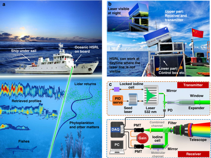
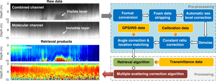
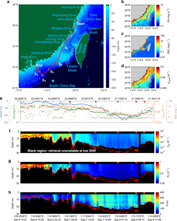
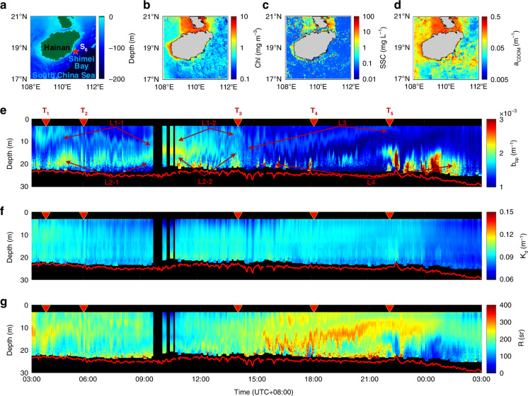
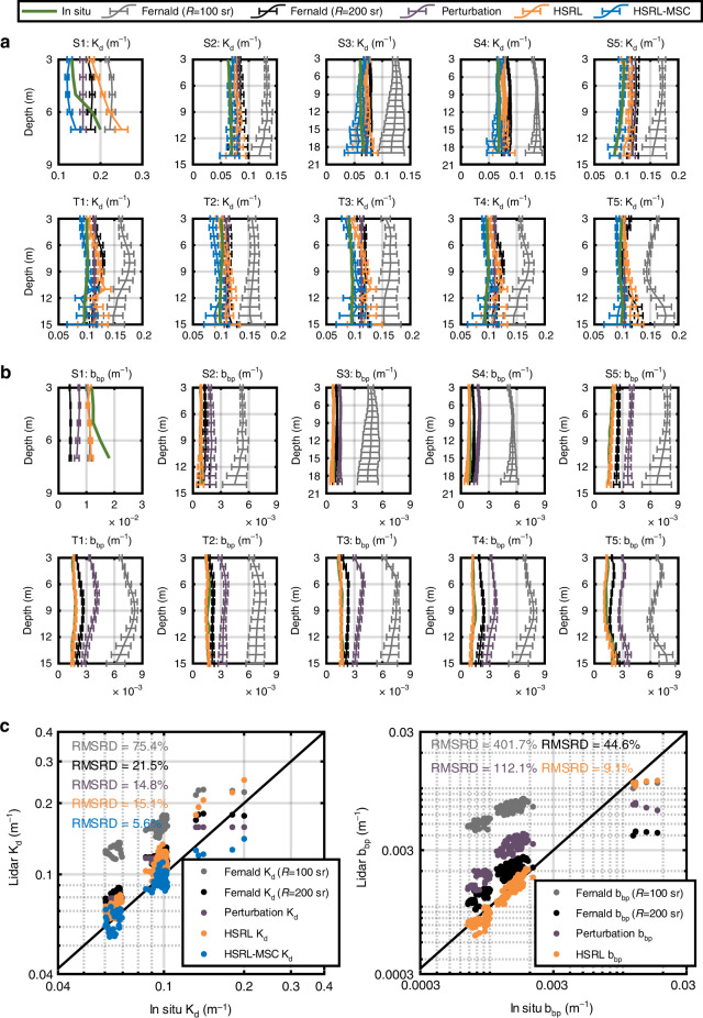
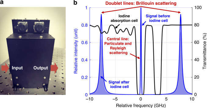
Lidar techniques present a distinctive ability to resolve vertical structure of optical properties within the upper water column at both day- and night-time. However, accuracy challenges remain for existing lidar instruments due to the ill-posed nature of elastic backscatter lidar retrievals and multiple scattering. Here we demonstrate the high performance of, to the best of our knowledge, the first shipborne oceanic high-spectral-resolution lidar (HSRL) and illustrate a multiple scattering correction algorithm to rigorously address the above challenges in estimating the depth-resolved diffuse attenuation coefficient Kd and the particulate backscattering coefficient bbp at 532 nm. HSRL data were collected during day- and night-time within the coastal areas of East China Sea and South China Sea, which are connected by the Taiwan Strait. Results include vertical profiles from open ocean waters to moderate turbid waters and first lidar continuous observation of diel vertical distribution of thin layers at a fixed station. The root-mean-square relative differences between the HSRL and coincident in situ measurements are 5.6% and 9.1% for Kd and bbp, respectively, corresponding to an improvement of 2.7-13.5 and 4.9-44.1 times, respectively, with respect to elastic backscatter lidar methods. Shipborne oceanic HSRLs with high performance are expected to be of paramount importance for the construction of 3D map of ocean ecosystem.
© 2022. The Author(s).
Conflict of interest statement
The authors declare no competing interests.
Figures
References
-
- Behrenfeld MJ, et al. Annual boom-bust cycles of polar phytoplankton biomass revealed by space-based lidar. Nat. Geosci. 2017;10:118–122. doi: 10.1038/ngeo2861. - DOI
-
- Behrenfeld MJ, et al. Space‐based lidar measurements of global ocean carbon stocks. Geophys. Res. Lett. 2013;40:4355–4360. doi: 10.1002/grl.50816. - DOI
-
- Churnside JH, Marchbanks RD. Subsurface plankton layers in the Arctic Ocean. Geophys. Res. Lett. 2015;42:4896–4902. doi: 10.1002/2015GL064503. - DOI
LinkOut - more resources
Full Text Sources
Other Literature Sources
