

Ecological niche modeling based on ensemble algorithms to predicting current and future potential distribution of African swine fever virus in China
- PMID: 36114368
- PMCID: PMC9481527
- DOI: 10.1038/s41598-022-20008-x
Ecological niche modeling based on ensemble algorithms to predicting current and future potential distribution of African swine fever virus in China
Abstract
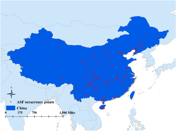
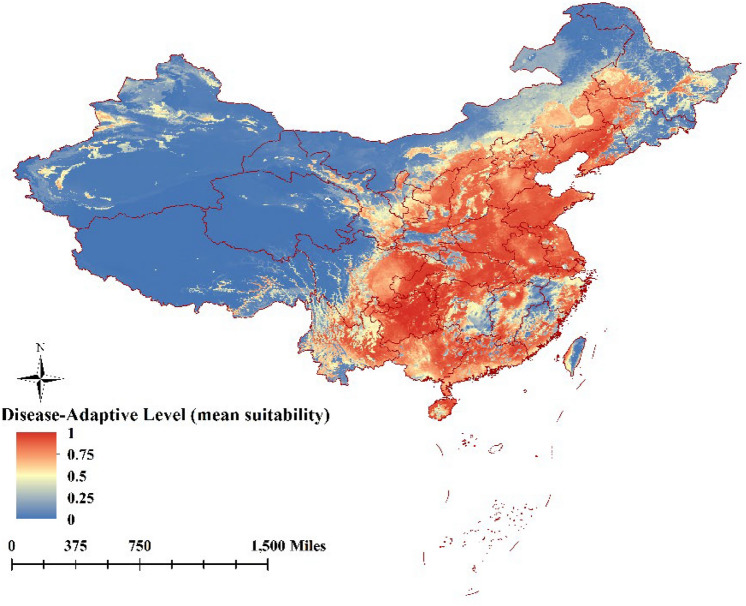
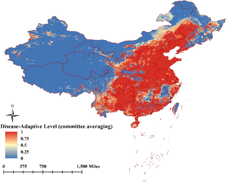
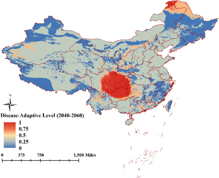
African swine fever (ASF) is a tick-borne infectious disease initially described in Shenyang province China in 2018 but is now currently present nationwide. ASF has high infectivity and mortality rates, which often results in transportation and trade bans, and high expenses to prevent and control the, hence causing huge economic losses and a huge negative impact on the Chinese pig farming industry. Ecological niche modeling has long been adopted in the epidemiology of infectious diseases, in particular vector-borne diseases. This study aimed to establish an ecological niche model combined with data from ASF incidence rates in China from August 2018 to December 2021 in order to predict areas for African swine fever virus (ASFV) distribution in China. The model was developed in R software using the biomod2 package and ensemble modeling techniques. Environmental and topographic variables included were mean diurnal range (°C), isothermality, mean temperature of wettest quarter (°C), precipitation seasonality (cv), mean precipitation of warmest quarter(mm), mean precipitation of coldest quarter (mm), normalized difference vegetation index, wind speed (m/s), solar radiation (kJ /day), and elevation/altitude (m). Contribution rates of the variables normalized difference vegetation index, mean temperature of wettest quarter, mean precipitation of coldest quarter, and mean precipitation of warmest quarter were, respectively, 47.61%, 28.85%, 10.85%, and 7.27% (according to CA), which accounted for over 80% of contribution rates related to variables. According to model prediction, most of areas revealed as suitable for ASF distribution are located in the southeast coast or central region of China, wherein environmental conditions are suitable for soft ticks' survival. In contrast, areas unsuitable for ASFV distribution in China are associated with arid climate and poor vegetation, which are less conducive to soft ticks' survival, hence to ASFV transmission. In addition, prediction spatial suitability for future ASFV distribution suggests narrower areas for ASFV spread. Thus, the ensemble model designed herein could be used to conceive more efficient prevention and control measure against ASF according to different geographical locations in China.
© 2022. The Author(s).
Conflict of interest statement
The authors declare no competing interests.
Figures


Similar articles
-
Ecological niche modeling predicting the potential distribution of African horse sickness virus from 2020 to 2060.Sci Rep. 2022 Feb 2;12(1):1748. doi: 10.1038/s41598-022-05826-3. Sci Rep. 2022. PMID: 35110661 Free PMC article.
-
Expounding the role of tick in Africa swine fever virus transmission and seeking effective prevention measures: A review.Front Immunol. 2022 Dec 16;13:1093599. doi: 10.3389/fimmu.2022.1093599. eCollection 2022. Front Immunol. 2022. PMID: 36591310 Free PMC article. Review.
-
One year of African swine fever outbreak in China.Acta Trop. 2020 Nov;211:105602. doi: 10.1016/j.actatropica.2020.105602. Epub 2020 Jun 26. Acta Trop. 2020. PMID: 32598922
-
African swine fever emerging in China: Distribution characteristics and high-risk areas.Prev Vet Med. 2020 Feb;175:104861. doi: 10.1016/j.prevetmed.2019.104861. Epub 2019 Nov 28. Prev Vet Med. 2020. PMID: 31810030
-
[African swine fever in Russian Federation].Vopr Virusol. 2012 Sep-Oct;57(5):4-10. Vopr Virusol. 2012. PMID: 23248852 Review. Russian.
Cited by
-
Predicting Disparity between ASF-Managed Areas and Wild Boar Habitats: A Case of South Korea.Animals (Basel). 2023 Nov 11;13(22):3482. doi: 10.3390/ani13223482. Animals (Basel). 2023. PMID: 38003100 Free PMC article.
-
Predicting Suitable Areas for African Swine Fever Outbreaks in Wild Boars in South Korea and Their Implications for Managing High-Risk Pig Farms.Animals (Basel). 2023 Jun 29;13(13):2148. doi: 10.3390/ani13132148. Animals (Basel). 2023. PMID: 37443946 Free PMC article.
-
Ecological niche model transferability of the white star apple (Chrysophyllum albidum G. Don) in the context of climate and global changes.Sci Rep. 2023 Feb 10;13(1):2430. doi: 10.1038/s41598-023-29048-3. Sci Rep. 2023. PMID: 36765149 Free PMC article.
-
Ecological Niche Modelling Approaches: Challenges and Applications in Vector-Borne Diseases.Trop Med Infect Dis. 2023 Mar 25;8(4):187. doi: 10.3390/tropicalmed8040187. Trop Med Infect Dis. 2023. PMID: 37104313 Free PMC article. Review.
-
Effect of climate change on the habitat suitability of the relict species Zelkova carpinifolia Spach using ensembled species distribution modelling.Sci Rep. 2024 Nov 14;14(1):27967. doi: 10.1038/s41598-024-78733-4. Sci Rep. 2024. PMID: 39543264 Free PMC article.
References
MeSH terms
LinkOut - more resources
Full Text Sources
