

Seismic surveys near gray whale feeding areas off Sakhalin Island, Russia: assessing impact and mitigation effectiveness
- PMID: 36255494
- PMCID: PMC9579104
- DOI: 10.1007/s10661-022-10016-9
Seismic surveys near gray whale feeding areas off Sakhalin Island, Russia: assessing impact and mitigation effectiveness
Abstract
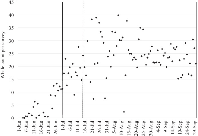
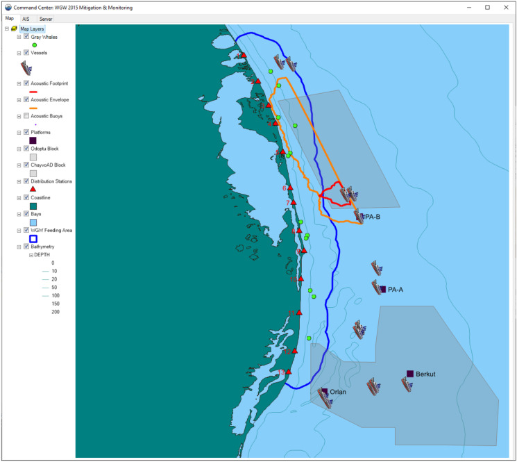
In 2015, two oil and gas companies conducted seismic surveys along the northeast coast of Sakhalin Island, Russia, near western gray whale (Eschrichtius robustus) feeding areas. This population of whales was listed as Critically Endangered at the time of the operations described here but has been reclassified as Endangered since 2018. The number and duration of the 2015 seismic surveys surpassed the level of previous seismic survey activity in this area, elevating concerns regarding disturbance of feeding gray whales and the potential for auditory injury. Exxon Neftegas Limited (ENL) developed a mitigation approach to address these concerns and, more importantly, implemented a comprehensive data collection strategy to assess the effectiveness of this approach. The mitigation approach prioritized completion of the seismic surveys closest to the nearshore feeding area as early in the season as possible, when fewer gray whales would be present. This was accomplished by increasing operational efficiency through the use of multiple seismic vessels and by establishing zones with specific seasonal criteria determining when air gun shutdowns would be implemented. These zones and seasonal criteria were based on pre-season modeled acoustic footprints of the air gun array and on gray whale distribution data collected over the previous 10 years. Real-time acoustic and whale sighting data were instrumental in the implementation of air gun shutdowns. The mitigation effectiveness of these shutdowns was assessed through analyzing short-term behavioral responses and shifts in gray whale distribution due to sound exposure. The overall mitigation strategy of an early survey completion was assessed through bioenergetics models that predict how reduced foraging activity might affect gray whale reproduction and maternal survival. This assessment relied on a total of 17 shore-based and 5 vessel-based teams collecting behavior, distribution, photo-identification, prey, and acoustic data. This paper describes the mitigation approach, the implementation of mitigation measures using real-time acoustic and gray whale location data, and the strategy to assess impacts and mitigation effectiveness.
Keywords: Bioenergetics; Eschrichtius robustus; Mitigation effectiveness; Russia; Sakhalin Island; Seismic survey.
© 2022. The Author(s).
Figures

References
-
- Blanchard, A. L., Ainsworth, L., Gailey, G., Demchenko, N. L., & Shcherbakov, I. A. (2022b). Benthic studies adjacent to Sakhalin Island, Russia, 2015 III: benthic energy density spatial models in the nearshore gray whale feeding area. Environmental Monitoring and Assessment, 194. 10.1007/s10661-022-10018-7 - DOI - PMC - PubMed
-
- Blanchard AL, Demchenko NL, Aerts LAM, Yazvenko SB, Ivin VV, Shcherbakov I, Melton HR. Prey biomass dynamics in gray whale feeding areas adjacent to Northeastern Sakhalin (the Sea of Okhotsk), Russia, 2001–2015. Marine Environmental Research. 2019;145:123–136. doi: 10.1016/j.marenvres.2019.02.008. - DOI - PubMed
-
- Blanchard, A. L., Demchenko, N. L., Aerts, L., Yazvenko, S. B., Ivin, V. V., & Shcherbakov, I. A. (2022a). Benthic studies adjacent to Sakhalin Island, Russia, 2015 I: benthic biomass and community structure in the nearshore gray whale feeding area. Environmental Monitoring and Assessment, 194. 10.1007/s10661-022-10017-8 - DOI - PMC - PubMed
-
- Blokhin, S. A., Maminov, M. K., & Kosygin, G. M. (1985). On the Korean-Okhotsk population of gray whales. Paper SC/36/PS7 presented to the IWC Scientific Committee (unpublished).
-
- Bowen SL. Probable extinction of the Korean stock of the gray whale (Eschrichtius robustus) Journal of Mammalogy. 1974;55:208–209. doi: 10.2307/1379272. - DOI
MeSH terms
LinkOut - more resources
Full Text Sources
