

A Review on Applications of Time-Lapse Electrical Resistivity Tomography Over the Last 30 Years : Perspectives for Mining Waste Monitoring
- PMID: 36285292
- PMCID: PMC9587091
- DOI: 10.1007/s10712-022-09731-2
A Review on Applications of Time-Lapse Electrical Resistivity Tomography Over the Last 30 Years : Perspectives for Mining Waste Monitoring
Abstract
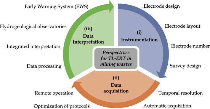
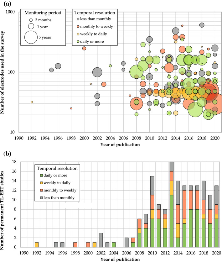
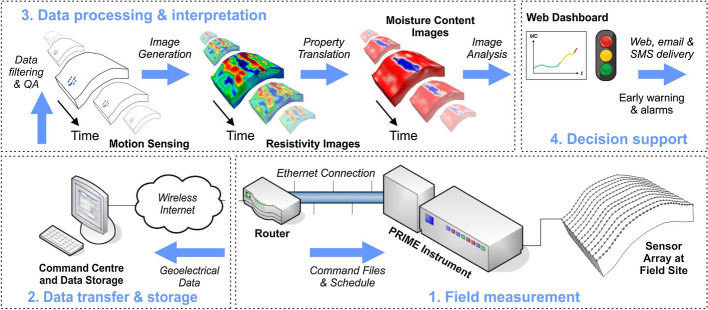
Mining operations generate large amounts of wastes which are usually stored into large-scale storage facilities which pose major environmental concerns and must be properly monitored to manage the risk of catastrophic failures and also to control the generation of contaminated mine drainage. In this context, non-invasive monitoring techniques such as time-lapse electrical resistivity tomography (TL-ERT) are promising since they provide large-scale subsurface information that complements surface observations (walkover, aerial photogrammetry or remote sensing) and traditional monitoring tools, which often sample a tiny proportion of the mining waste storage facilities. The purposes of this review are as follows: (i) to understand the current state of research on TL-ERT for various applications; (ii) to create a reference library for future research on TL-ERT and geoelectrical monitoring mining waste; and (iii) to identify promising areas of development and future research needs on this issue according to our experience. This review describes the theoretical basis of geoelectrical monitoring and provides an overview of TL-ERT applications and developments over the last 30 years from a database of over 650 case studies, not limited to mining operations (e.g., landslide, permafrost). In particular, the review focuses on the applications of ERT for mining waste characterization and monitoring and a database of 150 case studies is used to identify promising applications for long-term autonomous geoelectrical monitoring of the geotechnical and geochemical stability of mining wastes. Potential challenges that could emerge from a broader adoption of TL-ERT monitoring for mining wastes are discussed. The review also considers recent advances in instrumentation, data acquisition, processing and interpretation for long-term monitoring and draws future research perspectives and promising avenues which could help improve the design and accuracy of future geoelectric monitoring programs in mining wastes.
Keywords: Early warning systems; Geotechnical and geochemical stability; Mining wastes monitoring; Remote autonomous monitoring; Time-lapse electrical resistivity tomography.
© The Author(s) 2022.
Conflict of interest statement
Conflict of InterestThe authors declare no conflict of interest.
Figures


References
-
- Abdulsamad F, Revil A, Ahmed AS, et al. Induced polarization tomography applied to the detection and the monitoring of leaks in embankments. Eng Geol. 2019;254:89–101.
-
- Acosta J, Martínez-Pagán P, Martínez-Martínez S, et al. Assessment of environmental risk of reclaimed mining ponds using geophysics and geochemical techniques. J Geochem Explor. 2014;147:80–90.
-
- Adler A, Lionheart WR. Uses and abuses of Eidors: an extensible software base for EIT. Physiol Meas. 2006;27(5):S25. - PubMed
-
- Agricola G, Hoover H (1556/1912) De Re Metallica. Translated from the first latin edition of 1556 by Herbert Clark Hoover. London
-
- Al Hagrey S. Electrical resistivity imaging of tree trunks. Near Surf Geophys. 2006;4(3):179–187.
Publication types
LinkOut - more resources
Full Text Sources