

Anthropogenic Land Use and Land Cover Change as Potential Drivers of Sediment Sources in the Upper Crocodile River, North West Province, South Africa
- PMID: 36293894
- PMCID: PMC9603633
- DOI: 10.3390/ijerph192013313
Anthropogenic Land Use and Land Cover Change as Potential Drivers of Sediment Sources in the Upper Crocodile River, North West Province, South Africa
Abstract
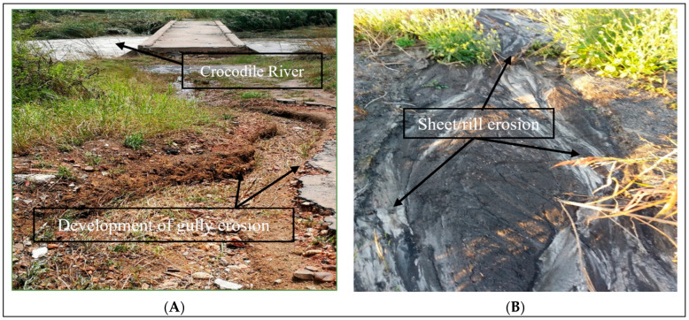
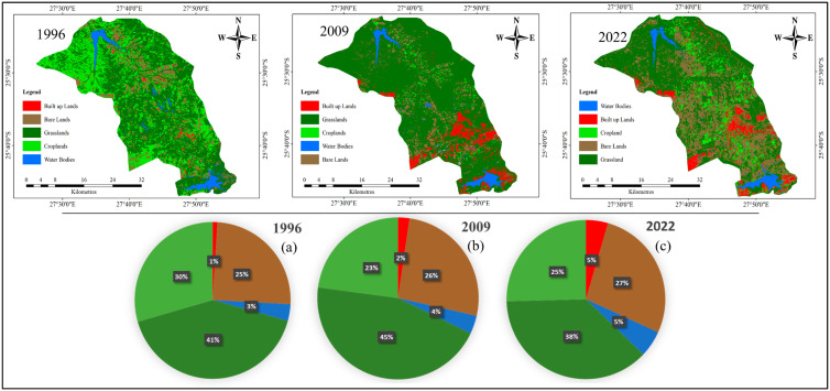
In this study, we investigated the accelerating pace of anthropogenic land use and land cover change (LULCC) disturbance, which has generated enormous impacts on the Crocodile River. Spot images from 1996, 2009 and 2022 were used to generate the land use maps and quantify the changes. A supervised classification with the maximum likelihood classifier was used to classify the images. Sediment sources were classified into two sources, revealed by erosional characteristics in the catchment. A gamma spectrometry detector, high-purity germanium (HPGe) "Well" detector by Canberra and inductively coupled plasma mass spectrometry (ICP-MS) were used for the analysis of the samples. The results revealed that from 1996-2022, built-up areas, bare land and water bodies increased by 3.48%, 2.47% and 1.90%, respectively. All the LULCC classes increased annually from 1996-2022, except for grassland, which shrunk. The results of the radionuclides analysis showed that 210Pbex was found to be a more effective tracer than 137Cs. The mass balance model revealed that subsurface sources contributed 60%, while surface sources contributed 40%, of the sediment load in the river. This research provides valuable information necessary for integrated catchment management policies for future LULCC and soil erosion to be adopted.
Keywords: land use/land cover dynamic; river pollution; sediment contamination; sediment source tracing.
Conflict of interest statement
The authors unanimously declare that they have no known competing financial interests or personal relationships that could appear to have influenced the work reported in this paper.
Figures
Similar articles
-
Assessment of Potentially Toxic Elements as Non-Point Sources of Contamination in the Upper Crocodile Catchment Area, North-West Province, South Africa.Int J Environ Res Public Health. 2018 Mar 23;15(4):576. doi: 10.3390/ijerph15040576. Int J Environ Res Public Health. 2018. PMID: 29570640 Free PMC article.
-
Tracing sediment sources in a plain river network area by using optimized experimental design and reflectance spectroscopy.Water Res. 2024 Feb 15;250:121041. doi: 10.1016/j.watres.2023.121041. Epub 2023 Dec 19. Water Res. 2024. PMID: 38176323
-
Subsoil erosion dominates the supply of fine sediment to rivers draining into Princess Charlotte Bay, Australia.J Environ Radioact. 2013 Oct;124:121-9. doi: 10.1016/j.jenvrad.2013.04.010. Epub 2013 May 30. J Environ Radioact. 2013. PMID: 23727879
-
Sediment source fingerprinting as an aid to large-scale landscape conservation and restoration: A review for the Mississippi River Basin.J Environ Manage. 2022 Dec 15;324:116260. doi: 10.1016/j.jenvman.2022.116260. Epub 2022 Sep 27. J Environ Manage. 2022. PMID: 36179467 Review.
-
Sources of variability in fatty acid (FA) biomarkers in the application of compound-specific stable isotopes (CSSIs) to soil and sediment fingerprinting and tracing: A review.Sci Total Environ. 2016 Sep 15;565:8-27. doi: 10.1016/j.scitotenv.2016.04.137. Epub 2016 May 4. Sci Total Environ. 2016. PMID: 27155260 Review.
References
-
- Haile A.T., Asfaw W., Rientjes T., Worako A.W. Deterioration of Streamflow Monitoring in Omo-Gibe Basin in Ethiopia. Hydrol. Sci. J. 2022;67:1040–1053. doi: 10.1080/02626667.2022.2060110. - DOI
-
- Programme World Water Assessment . The United Nations World Water Development Report 2018. United Nations Educational, Scientific and Cultural Organization; New York, NY, USA: 2018.
-
- Boretti A., Rosa L. Reassessing the Projections of the World Water Development Report. NPJ Clean Water. 2019;2:15. doi: 10.1038/s41545-019-0039-9. - DOI
MeSH terms
Substances
LinkOut - more resources
Full Text Sources
