Review
. 2023 Apr;52(4):711-732.
doi: 10.1007/s13280-022-01804-1. Epub 2022 Nov 2.

Towards a holistic paradigm for long-term snow avalanche risk assessment and mitigation

Affiliations
Review

Towards a holistic paradigm for long-term snow avalanche risk assessment and mitigation

Nicolas Eckert et al. Ambio. 2023 Apr.

Abstract

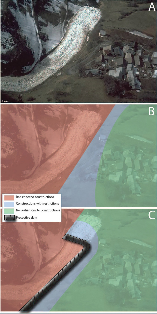
In mountain territories, snow avalanches are a prevalent threat. Long-term risk management involves defining meaningful compromises between protection and overall sustainability of communities and their environment. Methods able to (i) consider all sources of losses, (ii) account for the high uncertainty levels that affect all components of the risk and (iii) cope for marked non-stationarities should be employed. Yet, on the basis of a literature review and an analysis of relations to Sustainable Development Goals (SDGs), it is established that snow avalanche risk assessment and mitigation remain dominated by approaches that can be summed up as deterministic, hazard oriented, stationary and not holistic enough. A more comprehensive paradigm relying on formal statistical modelling is then proposed and first ideas to put it to work are formulated. Application to different mountain environments and broader risk problems is discussed.

Keywords: Environmental risks; Mountains; Socio-environmental changes; Statistical modelling; Sustainable development goals; Systemic approach.


Conflict of interest statement

The authors have no competing interests to declare that are relevant to the content of this article.

Figures

Fig. 1
Fig. 1
Land-use planning in avalanche-prone terrain: a compromise between safety and overall sustainability. A Avalanche deposit in the immediate vicinity of a village of the French Alps; B Schematic representation of a land-use planning map; C Same land-use planning map modified after the construction of a defence structure (protective dam). In BC red zones mean no possible constructions, blue zones indicate constructions possible with restrictions only (thicker walls, no windows on the wall facing the avalanche, etc.) and no restrictions apply in green areas
Fig. 2
Fig. 2
Avalanche risk in the Chamonix Valley, French Alps, in the vicinity of Taconnaz avalanche path. A Official French avalanche cadastre “CLPA” (March 2022 edition, full legend at https://www.avalanches.fr/static/1public/epaclpa/CLPA_feuilles_carte/CLPA_legende_carte.pdf), with black ellipse highlighting the massive Taconnaz protective system (deflective mounds and several dams); B the Taconnaz avalanche path and its protective system in March 2022 (photo credit @Inrae). The path extends from the highest summits of the Mont Blanc range to the valley bottom (Les Houches village); C Avalanche deposit on dwelling houses in Taconnaz, 20 March 1988 (photo credit @RTM74)
Fig. 3
Fig. 3
Diachronic evolution of the Chamonix Valley, French Alps, in the vicinity of Taconnaz avalanche path. A Landscape in 1903 (photo credit @ETH-Bibliotek Zurich); B same area in March 2022 (photo credit @Inrae). In AB, the red ellipse highlights the same dwelling house. In C, the white ellipse locates the Taconnaz protective system (Fig. 2B)
Fig. 4
Fig. 4
Avalanche hazard and land-use planning maps resulting from current disaster risk management approaches in the vicinity of Taconnaz avalanche path. A Official avalanche hazard map highlighting areas threatened by hazard levels classified as “moderate”, “strong” and “exceptional”, protective forests and defence structures (Taconnaz protective system at the centre); B Corresponding land-use planning map (zoom on Taconnaz runout zone). According to the current French legislation, there is no explicit risk map “between” the hazard and land-use planning maps. Both AB are from the 28 May 2015 edition of the local avalanche risk prevention plan—PPRA (MEDDE 2015), details and full legend at https://www.chamonix.fr/environnement-et-prevention-des-risques/prevention-des-risques/129-les-plans-opposables-ppri-ppra.html
Fig. 5
Fig. 5
Bibliometric analysis of scientific literature published between 2000 and 2021 regarding snow avalanches and related risk. A By scientific field/discipline. B By publication year
Fig. 6
Fig. 6
From A to B the proposed paradigm shift in long-term snow avalanche risk assessment and mitigation. Simplified illustration for a synthetic mountain slope. From the current (A) to the proposed (B) land-use map, one switches from a red zone defined by the sole extension of a reference avalanche event to a red zone based on risk estimates (death rates) and integrating uncertainty sources (larger in the future than in the current situation), various constraints (cost–benefit efficiency, ecosystem conservation and aesthetics) and changes through time of hazard and elements at risk
Fig. 7
Fig. 7
Accounting for non-stationarity in snow avalanche risk assessment and mitigation. Synthetic case study with arbitrary indices as hazard and risk measures showing how from chronicles of past events (C), evolution with climate and society of avalanche hazard (B) and related risk for settlements (A) can be quantified, including uncertainty as function of time. A also illustrates how different land-use planning strategies affect the future of risk. Moving from C to B involves accounting for the changing nature and amount of sources related to avalanches as function of time (Giacona et al. 2021). Moving from B to A requires combining changes in hazard with changes in exposure and vulnerability (e.g. Keylock et al. 1999)
Fig. 8
Fig. 8
Disciplines involved in the proposed holistic paradigm for long-term snow avalanche risk assessment and mitigation, and a possible formal modelling avenue to integrate them towards a common purpose
Fig. 9
Fig. 9
Scales relevant for avalanche risk and frames to bridge them. A Snow avalanche risk at intermediate (slope) scales, where avalanche activity interacts with elements at risk; B typical top-down climate modelling approach and C Hierarchical Bayesian Modelling approach. In A, avalanche hazard means seeing avalanche events as random occurrences as function of changing snow and weather conditions. In B, at each stage/scale, different GCM/RCM realizations account for varying input conditions (uncertainty and variability sources), leading to ensemble runs. In C, the nested model structure links path/slope scale hazard/damage occurrences to each other’s within a given massif/region. A major difficult is to feed the nested model structure with relevant information related to small-scale processes and large-scale drivers/trends

References

    1. Altaweel, M., Virapongse, A., Griffith, D., Alessa, L., Kliskey, A. (2015). A typology for complex social-ecological systems in mountain communities. Sustainability: Science, Practice and Policy, 11, pp. 1–13.
    1. Ammann, W., Bebi, P. (2000). WSL Institute for Snow and Avalanche Research SLF, Der Lawinenwinter 1999, Ereignisanalyse. SLF Davos, 588 p.
    1. Ancey C. Monte Carlo calibration of avalanches described as Coulomb fluid flows. Philosophical Transactions of the Royal Society A: Mathematical, Physical and Engineering Sciences. 2005;363:1529–1550. doi: 10.1098/rsta.2005.1593. - DOI - PubMed
    1. Ancey C. Are there “dragon-kings” events (ie genuine outliers) among extreme avalanches? The European Physical Journal Special Topics. 2012;205:117–129. doi: 10.1140/epjst/e2012-01565-7. - DOI
    1. Arnalds P, Jonasson K, Sigurdson ST. Avalanche hazard zoning in Iceland based on individual risk. Annals of Glaciology. 2004;38:285–290. doi: 10.3189/172756404781814816. - DOI

LinkOut - more resources