

A Framework for Interfacing and Partnering with Environmental Justice Communities as a Prelude to Human Health and Hazard Identification in the Vulnerable Census Tracts of Columbus, Ohio
- PMID: 36360728
- PMCID: PMC9654058
- DOI: 10.3390/ijerph192113846
A Framework for Interfacing and Partnering with Environmental Justice Communities as a Prelude to Human Health and Hazard Identification in the Vulnerable Census Tracts of Columbus, Ohio
Abstract
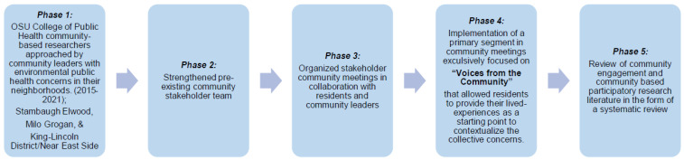
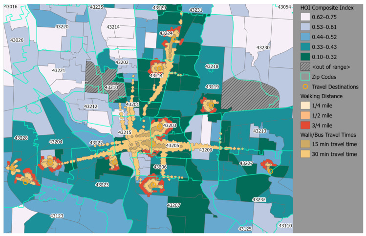
Columbus, Ohio is one of the more prosperous, well-educated, and progressive cities in the United States. However, it ranks as the second worst life expectancy at birth, has a census tract wealth gap (27-year disparity), and one of the higher infant mortality rates in the country. These data suggest that there are likely several high-risk, vulnerable neighborhoods in Columbus with residents experiencing disparate and adverse outcomes. Illustrative of this fact are studies that have examined the social processes and mechanisms through which neighborhood contexts are at the forefront, including exposures to chemical stressors such as particulate matter (PM2.5) as well as non-chemical stressors including violence, social determinants of health, zoning, and land use policies. It is documented that disparate and adverse outcomes are magnified in the vulnerable neighborhoods on the Near East Side as compared to Columbus city proper, Franklin County and/or the state of Ohio. As such, we developed a nuanced community engagement framework to identify potential environmental hazards associated with adverse pregnancy outcomes in those census tracts. The refined framework uses a blended version of traditional community-based participatory research (CBPR) models and is referred to as E6, Enhancing Environmental Endeavors via e-Equity, Education, and Empowerment.
Keywords: Public Health Exposome; community engagement; community-based participatory research (CBPR); environmental justice; environmental public health practitioner; hazard identification; stakeholder coalition; urban census tracts.
Conflict of interest statement
The authors declare no conflict of interest.
Figures


Similar articles
-
Application of the Public Health Exposome Framework to Estimate Phenotypes of Resilience in a Model Ohio African-American Women's Cohort.J Urban Health. 2019 Mar;96(Suppl 1):57-71. doi: 10.1007/s11524-018-00338-w. J Urban Health. 2019. PMID: 30758792 Free PMC article.
-
The Health Opportunity Index: Understanding the Input to Disparate Health Outcomes in Vulnerable and High-Risk Census Tracts.Int J Environ Res Public Health. 2020 Aug 10;17(16):5767. doi: 10.3390/ijerph17165767. Int J Environ Res Public Health. 2020. PMID: 32785046 Free PMC article.
-
Utilizing social determinants of health to identify most vulnerable neighborhoods-Latent class analysis and GIS map.Prev Med. 2024 Jul;184:107997. doi: 10.1016/j.ypmed.2024.107997. Epub 2024 May 9. Prev Med. 2024. PMID: 38729527
-
Leveraging Implementation Science to Advance Environmental Justice Research and Achieve Health Equity through Neighborhood and Policy Interventions.Annu Rev Public Health. 2024 May;45(1):89-108. doi: 10.1146/annurev-publhealth-060222-033003. Epub 2024 Apr 3. Annu Rev Public Health. 2024. PMID: 38166499 Review.
-
Concepts for Studying Urban Environmental Justice.Curr Environ Health Rep. 2017 Mar;4(1):61-67. doi: 10.1007/s40572-017-0123-6. Curr Environ Health Rep. 2017. PMID: 28101730 Review.
Cited by
-
Community-level exposomics: a population-centered approach to address public health concerns.Exposome. 2023;3(1):osad009. doi: 10.1093/exposome/osad009. Epub 2023 Nov 16. Exposome. 2023. PMID: 38550543 Free PMC article.
References
-
- Jiao Y., Bower J.K., Im W., Basta N., Obrycki J., Al-Hamdan M.Z., Wilder A., Bollinger C.E., Zhang T., Hatten L.S., et al. Application of Citizen Science Risk Communication Tools in a Vulnerable Urban Community. Int. J. Environ. Res. Public Health. 2015;13:11. doi: 10.3390/ijerph13010011. - DOI - PMC - PubMed
-
- Min E., Gruen D., Banerjee D., Echeverria T., Freelander L., Schmeltz M., Saganić E., Piazza M., Galaviz V.E., Yost M., et al. The Washington State Environmental Health Disparities Map: Development of a Community-Responsive Cumulative Impacts Assessment Tool. Int. J. Environ. Res. Public Health. 2019;16:4470. doi: 10.3390/ijerph16224470. - DOI - PMC - PubMed
-
- Kaufman A., Williams R., Barzyk T., Greenberg M., O’Shea M., Sheridan P., Hoang A., Ash C., Teitz A., Mustafa M., et al. A Citizen Science and Government Collaboration: Developing Tools to Facilitate Community Air Monitoring. Environ. Justice. 2017;10:51–61. doi: 10.1089/env.2016.0044. - DOI - PMC - PubMed
-
- Cifuentes P., Reichard J., Im W., Smith S., Colen C., Giurgescu C., Williams K.P., Gillespie S., Juarez P.D., Hood D.B. Application of the Public Health Exposome Framework to Estimate Phenotypes of Resilience in a Model Ohio African-American Women’s Cohort. J. Hered. 2019;96:57–71. doi: 10.1007/s11524-018-00338-w. - DOI - PMC - PubMed
Publication types
MeSH terms
Substances
LinkOut - more resources
Full Text Sources
Research Materials
Miscellaneous
