

Analysis of Landscape Characteristics and Influencing Factors of Residential Areas on the Qinghai-Tibet Plateau: A Case Study of Tibet, China
- PMID: 36429669
- PMCID: PMC9691090
- DOI: 10.3390/ijerph192214951
Analysis of Landscape Characteristics and Influencing Factors of Residential Areas on the Qinghai-Tibet Plateau: A Case Study of Tibet, China
Abstract
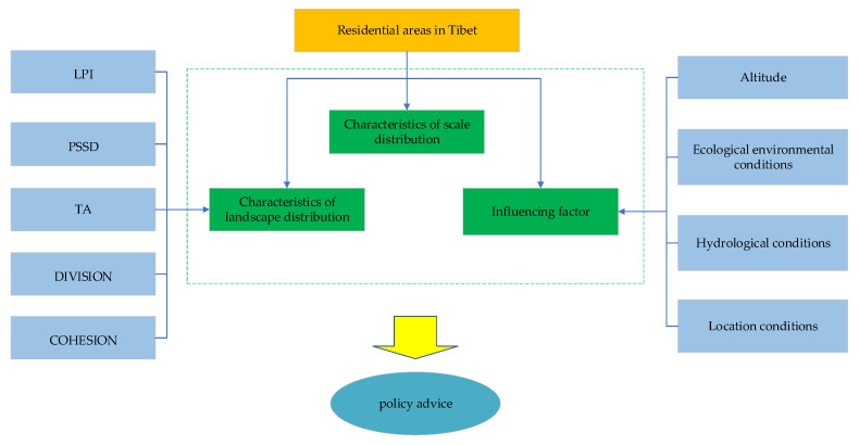
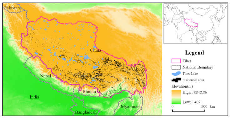
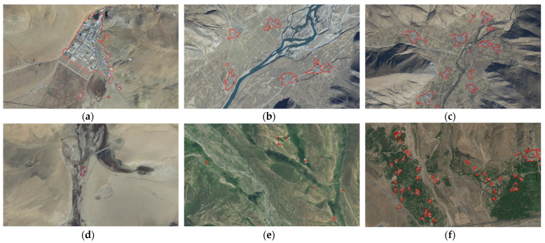
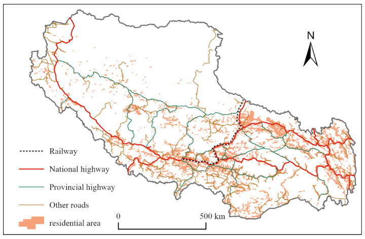
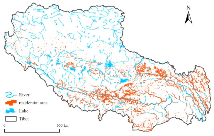
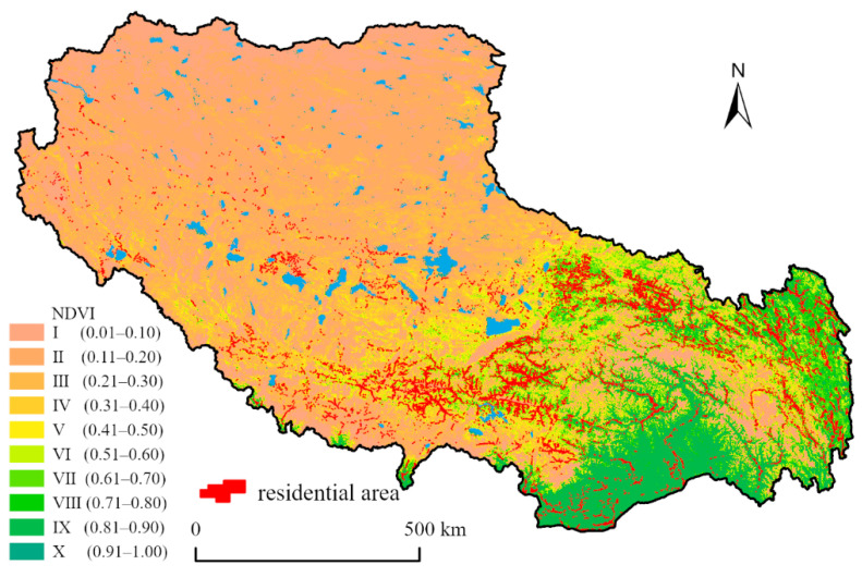
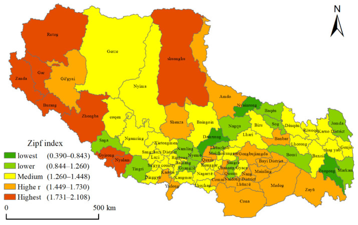
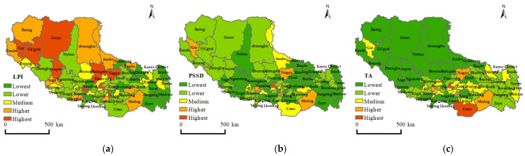
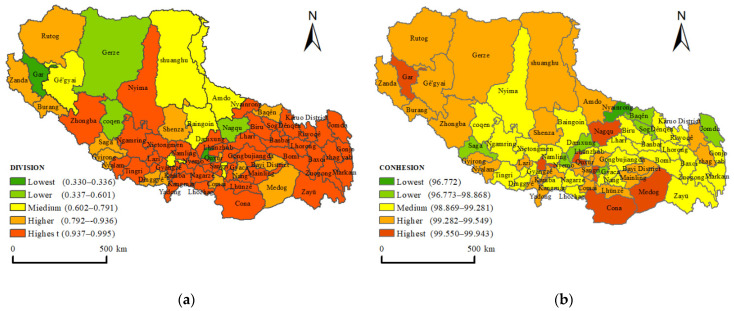
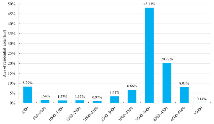
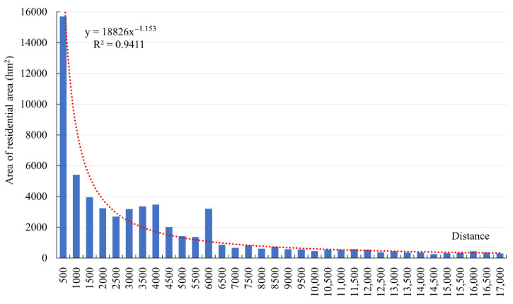
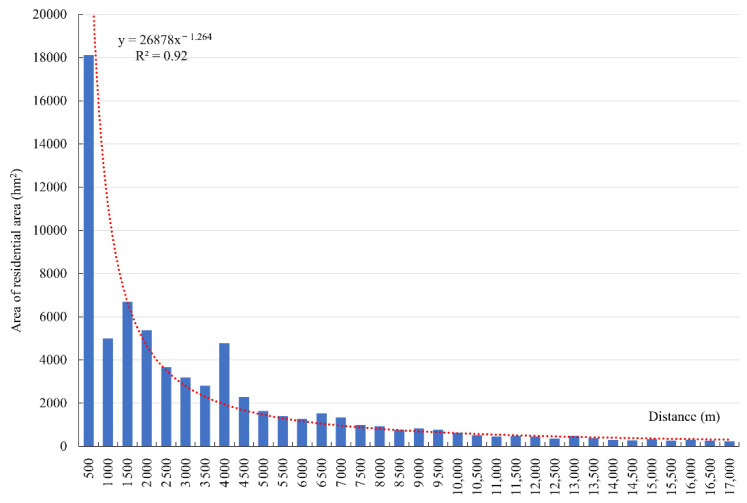
The Qinghai-Tibet Plateau is the largest ecological barrier and one of the most vulnerable areas of the ecological environmental system. However, the increasing frequency of human activities in the Qinghai-Tibet Plateau has led to strong interference. Residential areas are the main places in which human activities are carried out and, as such, can effectively reflect the intensity of activities. Based on this, this research takes the Tibet Autonomous Region as the study area and analyzes the distribution characteristics of Tibetan residential areas using Zipf's law and various landscape indices, as well as discussing the influences of altitude, hydrology, ecological environment, and location on residential area distribution. The obtained results indicate the following: (1) The residential areas in Tibet basically conform to the rank-size principle. The residential areas in central and northwest Tibet are concentrated in size distribution, and the relatively large residential areas are prominent, while the residential areas in the eastern Hengduan mountain region are relatively balanced in size distribution. (2) The landscape index results demonstrate that the counties with an unbalanced distribution of residential areas are mainly concentrated in the northwest of Tibet, while the residential areas in the counties and regions where the administrative stations of each prefecture-level city (or region) are located tend to present a polarization phenomenon, with large patches. The area distribution of residential areas showed a "medium-high-low" pattern from southeast to northwest. The residential areas in eastern Tibet have a high degree of fragmentation and a low degree of aggregation, while the residential areas in northwest Tibet have a low degree of fragmentation and a relatively high degree of aggregation. (3) The residential areas in Tibet are most concentrated in the altitude range of 3000-5000 m above sea level and their water affinity and road-affinity are strong, with the distribution of residential areas within 500 m of roads and water networks accounting for more than one-quarter. The vegetation coverage in the residential areas is low, inconsistent with the surface vegetation coverage rate over the whole of Tibet.
Keywords: Tibet; influencing factors; landscape characteristics; residential area.
Conflict of interest statement
The authors declare no conflict of interest.
Figures
Similar articles
-
Effects of hydrothermal factors and human activities on the vegetation coverage of the Qinghai-Tibet Plateau.Sci Rep. 2023 Aug 1;13(1):12488. doi: 10.1038/s41598-023-39761-8. Sci Rep. 2023. PMID: 37528182 Free PMC article.
-
[Distribution Characteristics and Ecological Risk Assessment of Soil Heavy Metals in Typical Watersheds of the Qinghai-Tibet Plateau].Huan Jing Ke Xue. 2021 Sep 8;42(9):4422-4431. doi: 10.13227/j.hjkx.202012123. Huan Jing Ke Xue. 2021. PMID: 34414742 Chinese.
-
Determining the contributions of climate change and human activities to the vegetation NPP dynamics in the Qinghai-Tibet Plateau, China, from 2000 to 2015.Environ Monit Assess. 2020 Sep 28;192(10):663. doi: 10.1007/s10661-020-08606-6. Environ Monit Assess. 2020. PMID: 32989603
-
Information entropy and elasticity analysis of the land use structure change influencing eco-environmental quality in Qinghai-Tibet Plateau from 1990 to 2015.Environ Sci Pollut Res Int. 2022 Mar;29(13):18348-18364. doi: 10.1007/s11356-021-17978-2. Epub 2022 Jan 12. Environ Sci Pollut Res Int. 2022. PMID: 35022979 Review.
-
The Qinghai-Tibetan plateau: how high do Tibetans live?High Alt Med Biol. 2001 Winter;2(4):489-99. doi: 10.1089/152702901753397054. High Alt Med Biol. 2001. PMID: 11809089 Review.
Cited by
-
Vectorized building rooftop prints of the Qinghai-Tibetan Plateau and its neighboring regions.Sci Data. 2025 Jun 17;12(1):1013. doi: 10.1038/s41597-025-05266-4. Sci Data. 2025. PMID: 40527889 Free PMC article.
-
Adaptive management for alpine grassland of the Tibetan Plateau based on a multi-criteria assessment.Front Plant Sci. 2025 Mar 12;16:1518721. doi: 10.3389/fpls.2025.1518721. eCollection 2025. Front Plant Sci. 2025. PMID: 40144763 Free PMC article.
References
-
- Wu C. Study on the Spatial Differences in Land-Use Change and Driving Factors in Tibet. Land. 2022;11:1584. doi: 10.3390/land11091584. - DOI
-
- Jiang Y.J., Li S.J., Shen D.F., Chen W., Jin C. Climate change and its impact on the lake environment in the Tibetan Plateau in 1971–2008. Sci. Geogr. Sin. 2012;32:1503–1512.
-
- Shen B., Ma Q.Q., Cheng Y.X., Chang S.H., Li Y., Guo J.M., Hou F.J. Effect of grazing systems on soil seedbank: A case study of an alpine meadow in the eastern Qinghai-Tibet Plateau. Pratacultural Sci. 2018;35:791–799.
Publication types
MeSH terms
Substances
LinkOut - more resources
Full Text Sources
