

A database of water chemistry in eastern Siberian rivers
- PMID: 36450810
- PMCID: PMC9712607
- DOI: 10.1038/s41597-022-01844-y
A database of water chemistry in eastern Siberian rivers
Erratum in
-
Author Correction: A database of water chemistry in eastern Siberian rivers.Sci Data. 2023 Jan 10;10(1):19. doi: 10.1038/s41597-023-01927-4. Sci Data. 2023. PMID: 36627312 Free PMC article. No abstract available.
Abstract
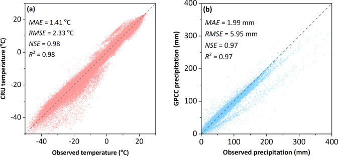
Permafrost degradation leads to considerable changes in river ecosystems. The Eastern Siberian River Chemistry (ESRC) database was constructed to create a spatially extensive river chemistry database to assess climate warming-induced changes in freshwater systems in permafrost-dominated eastern Siberia. The database includes 9487 major ion (Na+, K+, Ca2+, Mg2+, Cl-, SO42- and HCO3-) data of chemical results from 1434 water samples collected mainly in six large river basins in eastern Siberia spanning 1940-2019. Data were obtained from public databases, scientific literature in English and Russian, and researchers and were formatted with a consistent table structure. The database is transparent and reproducible. Climate variable (air temperature and precipitation) data, discharge data, trace element concentration data, and isotope data at the basin and subbasin scales are also provided. This database enhances knowledge about the water chemistry of the permafrost region, especially in eastern Siberia, where data are scarce. The database will be useful to those assessing spatiotemporal changes in river water chemistry associated with permafrost degradation or other environmental stressors in a warmer climate.
© 2022. The Author(s).
Conflict of interest statement
The authors declare no competing interests.
Figures


References
-
- Holmes RM, et al. Seasonal and Annual Fluxes of Nutrients and Organic Matter from Large Rivers to the Arctic Ocean and Surrounding Seas. Estuaries and Coasts. 2012;35:369–382. doi: 10.1007/s12237-011-9386-6. - DOI
-
- Shiklomanov, A. et al. in Arct. Hydrology, Permafr. Ecosyst. (eds D., Yang & D. L., Kane) 703–738 (Springer International Publishing, 2021).
-
- Serreze, M. C. et al. The large-scale freshwater cycle of the Arctic. Journal of Geophysical Research: Oceans111, 10.1029/2005jc003424 (2006).
-
- White, D. et al. The arctic freshwater system: Changes and impacts. Journal of Geophysical Research: Biogeosciences112, 10.1029/2006JG000353 (2007).
Publication types
Grants and funding
LinkOut - more resources
Full Text Sources
Miscellaneous
