Community-Based Surveillance and Geographic Information System‒Linked Contact Tracing in COVID-19 Case Identification, Ghana, March‒June 2020
- PMID: 36502391
- PMCID: PMC9745224
- DOI: 10.3201/eid2813.221068
Community-Based Surveillance and Geographic Information System‒Linked Contact Tracing in COVID-19 Case Identification, Ghana, March‒June 2020
Abstract
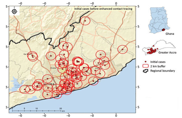
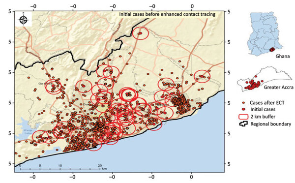
In response to the COVID-19 pandemic, Ghana implemented various mitigation strategies. We describe use of geographic information system (GIS)‒linked contact tracing and increased community-based surveillance (CBS) to help control spread of COVID-19 in Ghana. GIS-linked contact tracing was conducted during March 31-June 16, 2020, in 43 urban districts across 6 regions, and 1-time reverse transcription PCR testing of all persons within a 2-km radius of a confirmed case was performed. CBS was intensified in 6 rural districts during the same period. We extracted and analyzed data from Surveillance Outbreak Response Management and Analysis System and CBS registers. A total of 3,202 COVID-19 cases reported through GIS-linked contact tracing were associated with a 4-fold increase in the weekly number of reported SARS-CoV-2 infected cases. CBS identified 5.1% (8/157) of confirmed cases in 6 districts assessed. Adaptation of new methods, such as GIS-linked contact tracing and intensified CBS, improved COVID-19 case detection in Ghana.
Keywords: COVID-19; GIS; Ghana; case identification; community-based surveillance; contact tracing; coronavirus disease; districts; geographic information system; respiratory infections; zoonoses.
Figures
References
-
- Tet M, Schatz E, Liebenberg L. Methods in the time of COVID-19: the vital role of qualitative inquiries. Int J Qual Methods. 2020;19: Epub ahead of print. 10.1177/1609406920920962 - DOI
-
- World Health Organization. Official COVID-19 information [cited 2022 Oct 27]. https://covid19.who.int
-
- World Health Organization. WHO health emergency dashboard [cited 2022 Oct 27]. https://covid19.who.int/region/afro/country/gh
Publication types
MeSH terms
LinkOut - more resources
Full Text Sources
Medical
Miscellaneous