. 2022 Dec 22;13(1):7893.
doi: 10.1038/s41467-022-35208-2.

Greenstone burial-exhumation cycles at the late Archean transition to plate tectonics

Affiliations

Greenstone burial-exhumation cycles at the late Archean transition to plate tectonics

Zibra Ivan et al. Nat Commun. .

Abstract

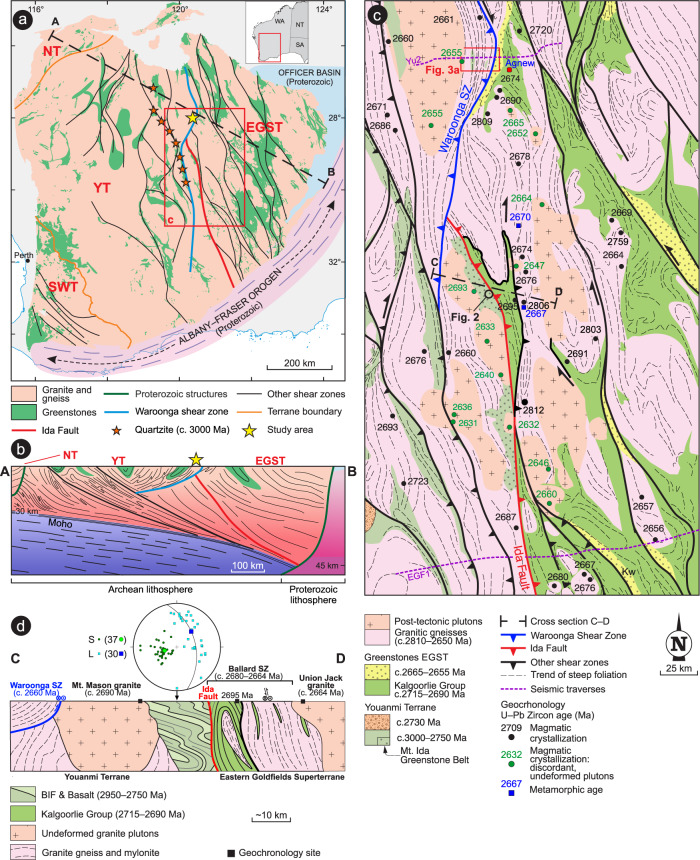
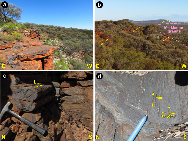
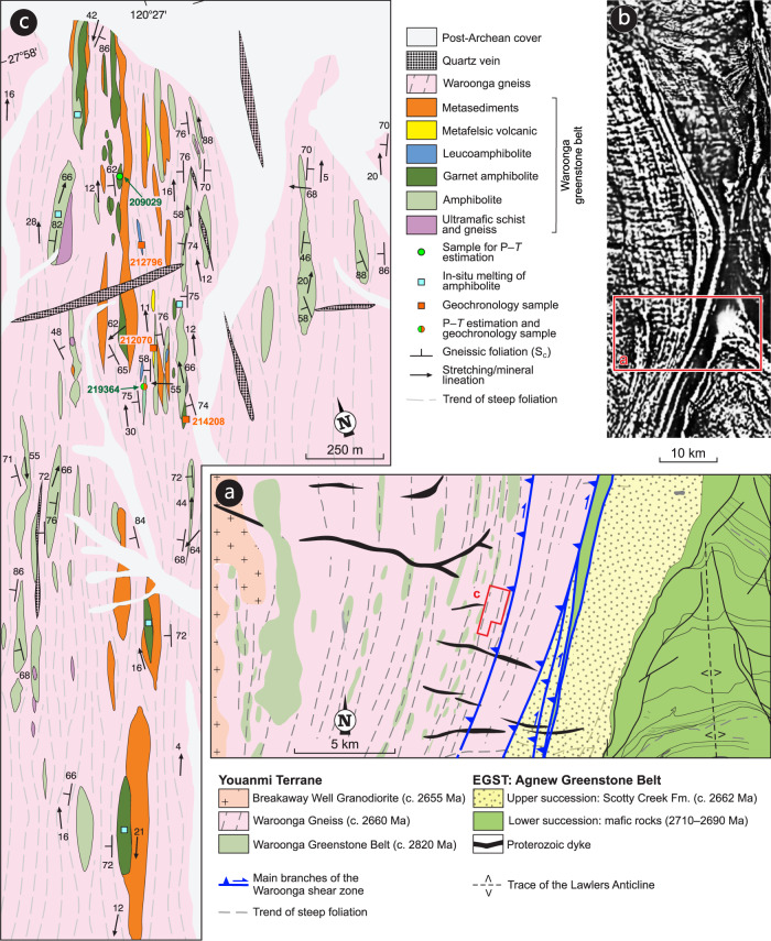
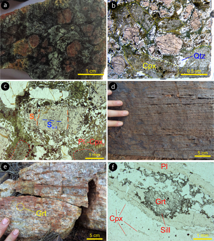
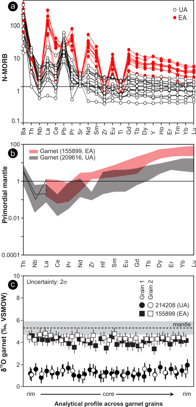
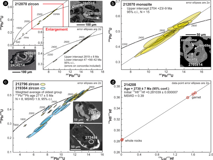
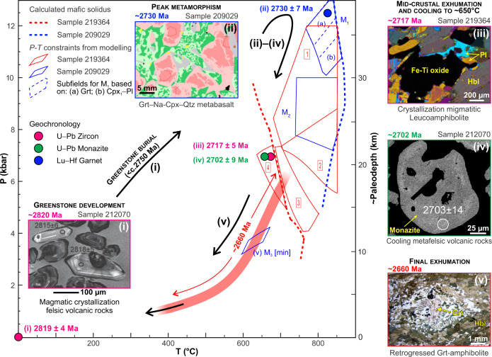
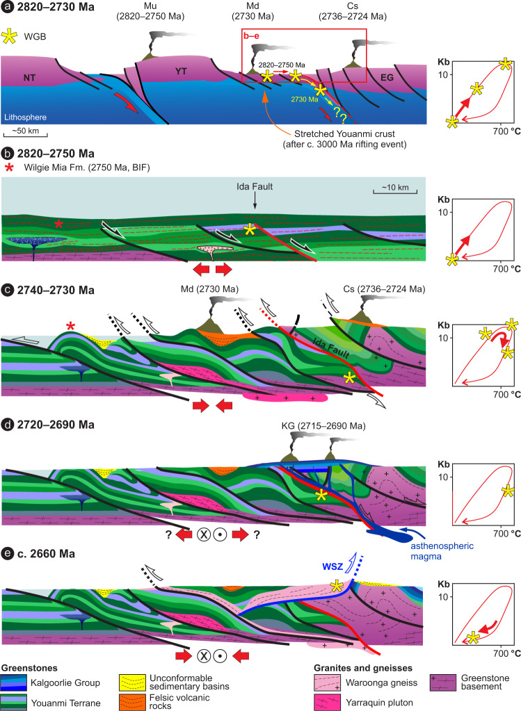
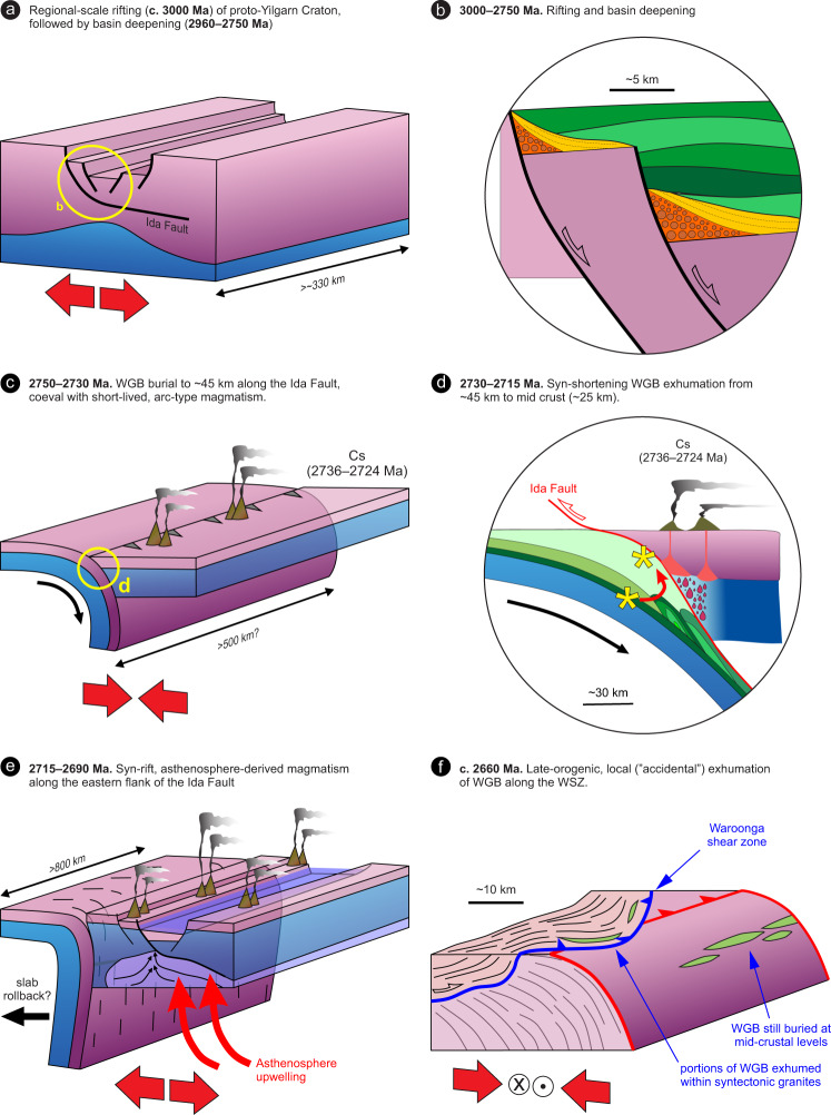
Converging lines of evidence suggest that, during the late Archean, Earth completed its transition from a stagnant-lid to a plate tectonics regime, although how and when this transition occurred is debated. The geological record indicates that some form of subduction, a key component of plate tectonics-has operated since the Mesoarchean, even though the tectonic style and timescales of burial and exhumation cycles within ancient convergent margins are poorly constrained. Here, we present a Neoarchean pressure-temperature-time (P-T-t) path from supracrustal rocks of the transpressional Yilgarn orogen (Western Australia), which documents how sea-floor-altered rocks underwent deep burial then exhumation during shortening that was unrelated to the episode of burial. Archean subduction, even if generally short-lived, was capable of producing eclogites along converging lithosphere boundaries, although exhumation processes in those environments were likely less efficient than today, such that return of high-pressure rocks to the surface was rare.


Conflict of interest statement

The authors declare no competing interests.

Figures

Fig. 1
Fig. 1. Geological maps and cross sections, Yilgarn Craton.
a Simplified geological map of the Yilgarn Craton, showing the subdivision into main terranes (NT: Narryer; YT: Youanmi; SWT: Southwest; EGST: Eastern Goldfields Superterrane), and the network of craton-scale shear zones. The black dashed line shows the trace of the cross section shown in b. b Geological cross section across the northern part of the craton, illustrating the main crustal architecture, characterized by east-dipping Moho and listric, crustal-scale shear zones. c Geological map of the central portion of the Yilgarn Craton. Note that the Ida Fault is truncated by the Waroonga Shear Zone. Ages of magmatic crystallization for granite plutons are from Geoscience Australia and Geological Survey of Western Australia databases. d Geological cross-section across the central portion of the Ida Fault. The equal-angle plot shows poles to gently east-dipping foliation and the gently east-plunging stretching lineation for the banded iron formation (BIF)-basalt sequence (with indication of mean values), in striking contrast with that of the transpressional fabric exposed in the rest of the craton, which is invariably steeply dipping. The gently dipping fabric is postdated by the undeformed, c. 2690 Ma Mt. Mason granite, which was emplaced at depth, during the deposition of the Kalgoorlie Group. c for cross-section trace. Compilation of maps and cross-sections is based on combined field and geophysical data.
Fig. 2
Fig. 2. Prominent outcrop-scale features of the Mount Ida greenstone belt.
Outcrops location shown in Fig. 1b. a Approximately 20 m-thick BIF (Banded Iron Formation) ridge, showing gently east-dipping transposed bedding. b Panoramic view from Mt Mason, looking southward. Interlayered, weathering-resistant BIF and basalts are associated with a prominent topographic scarp, 100–200 m higher than the flat landscape at west, dominated by the more erodible granite. The consistently east dipping transposed bedding in BIF (marked by the dashed lines) can be followed for nearly 200 km along strike. c Close-up view of the transposed bedding in BIF, with tight isoclinal folds whose axes, subparallel to the stretching lineation, are invariably gently east-plunging. d View from above (parallel to the transposed bedding) of BIF exposure. The prominent stretching lineation is marked by elongate quartz-magnetite aggregates.
Fig. 3
Fig. 3. Geological maps of the Waroonga shear zone.
a Geological map of the study area, across the central portion of the Waroonga shear zone (Fig. 1c for location). The rectangle shows the location of the map shown in panel c. b Merged magnetic anomaly map of the Waroonga shear zone, as part of the magnetic anomaly grid (40 m) of Western Australia, Version 1 – 2013. The full map is available on the Geological Survey of Western Australia (GSWA) website: http://www.dmp.wa.gov.au/Geological-Survey/Regional-geophysical-survey-data-1392.aspx. The rectangle shows the location of panel a. c Geological map of the sampling area, showing location of samples collected for geochronology and P–T estimations.
Fig. 4
Fig. 4. Typical meso- and microscale features of the main rock types in the Waroonga greenstone belt.
a Polished hand specimen (sample 209029) from the core of a garnet amphibolite body. Subhedral to euhedral, cm-sized garnet and pale-green clinopyroxene porphyroblasts (M1 assemblage) show variable degrees of retrogression, as marked by hornblende-rich black rims. b Plane polarized light view of hand sample shown in a, highlighting the texturally preserved peak (M1) assemblage of clinopyroxene, garnet, quartz and rutile. Peak pyroxene (Cpx1), whose outline is marked by dashed yellow lines, is replaced by clinopyroxene (Cpx2)–plagioclase1 symplectites (M2 assemblage) and by hornblende–plagioclase2 symplectites. The latter developed at the expenses of both Cpx1 and garnet. c Garnet porphyroblast (sample 209029) preserving evidence of two internal foliations (Sx crenulating Sx-1 foliation) that, since they predate garnet growth, find no equivalence in mesoscale fabrics observable in the field. d Transposed bedding in strongly deformed Banded Iron Formation (BIF), showing rootless, isoclinal folds. e Transposed bedding in strongly deformed quartzite, in primary contact with BIF. f Micrograph from quartzite shown in e, with granulite-facies assemblage comprising skeletal garnet (with sillimanite inclusions) wrapped by plagioclase ribbons, and small clinopyroxene porphyroblasts scattered in quartz ribbons. Plane polarized light.
Fig. 5
Fig. 5. Trace-element and O-isotope compositions of amphibolite from the Waroonga greenstone belt.
a Normal mid-ocean ridge basalts (N-MORB) normalized incompatible trace-element patterns of the garnet amphibolite, showing the distinctive differences in rare Earth elements (REE), large ion lithophile elements (LILE), Th and, in particular, high field strength elements (HFSE), in the EA group. b Mantle-normalised incompatible trace-element patterns of garnet in UA and EA. Compared with UA, EA garnets show strong enrichments in REE, without enrichment in Nb (only two analyses, both shown as traces, with Nb above detection) or Th. c Secondary ion mass spectrometer (SIMS) δ18O analyses across garnet grains of sample 214208 and 155899. The grey bar shows the mantle δ18O range.
Fig. 6
Fig. 6. Geochronology results for zircon, monazite and garnet.
ac Concordia diagrams of U-Pb analyses of zircon and monazite. The inset in each panel shows representative cathodoluminescence (CL; zircon) and back-scattered electron (BSE; monazite) images of analysed grains with the spot location (white circle) and corresponding 207Pb/206Pb dates. d Lu–Hf isochron diagram showing data obtained from three garnet fractions, the corresponding whole rock, and a garnet-free whole rock aliquot. The red circles outline the position of individual data points, which are only barely resolvable at this scale.
Fig. 7
Fig. 7. Metamorphic evolution of the Waroonga greenstone belt (WGB).
Summary of the metamorphic evolution for the WGB, based on phase equilibrium modelling of samples 209029 and 219364. The five insets show the representative microstructures for each of the steps that we used to trace the P–T–t path. (i) Dating of euhedral zircons in sample 212070 define the formation age of the WGB; (ii) the peak assemblage in amphibolite clinopyroxene–garnet–quartz is well preserved in sample 209029, and dated by garnet-whole rock Lu–Hf isotopes in chemically similar sample 214208; zircon dating in leucoamphibolite (iii) and monazite dating in sample 212070 (iv) represent mid-crustal cooling of the WGB, during stepwise exhumation; (v) at c. 2660 Ma, exhumation was associated with the widespread development (in garnet amphibolite) of synkinematic hornblende, replacing both garnet (as shown in the micrograph) and clinopyroxene.
Fig. 8
Fig. 8. Tectonomagmatic evolution of the Waroonga greenstone belt (WGB) and the Yilgarn lithosphere.
Cartoon outlining the tectonomagmatic evolution of the WGB and the Yilgarn lithosphere in the Meso- to Neoarchean. Note the change of scale from (a) to (b). a Long-term plate configuration characterized by the convergence between the Narryer (NT) and the Youanmi-Eastern goldfields terranes (YT and EG, respectively). Volcanism with an arc signature occurred in the Murchison (Mu), Marda (Md) and Cosmos(Cs) areas. b The pre-orogenic period (until c.2750 Ma) reflects the accumulation of a thick greenstone pile dominated by mafic–ultramafic volcanic rocks interlayered with BIFs, devoid of any clastic input. The WGB developed at c. 2820 Ma, in the vicinity of the proto-Ida Fault. c Synmagmatic shearing along large-scale, east-dipping contractional structures, together with subaerial volcanism and development of high-energy sedimentary basins above a regional unconformity, mark the onset of the Neoarchean orogeny. Meanwhile, the WGB was buried to lower-crustal depths (12–13 Kbar), along the Ida Fault, and subsequently partly exhumed to mid-crustal levels (7 kbar). Coeval volcanism with arc affinity occurred in the Cosmos area (Cs).d Mafic–ultramafic magmatism along the eastern margin of the Youanmi Terrane produced the Kalgoorlie Group greenstone sequence (KG). Asthenospheric magma (pictured in dark blue) was likely channelled along the main crustal-scale structure in the area, the Ida Fault. e Late-orogenic exhumation of the WGB took place along the Waroonga shear zone, which channelled the emplacement of the syntectonic Waroonga Gneiss, transporting slivers of the WGB to their present position.
Fig. 9
Fig. 9. Tectonic evolution of the central portion of the Yilgarn Craton.
Meso- to Neoarchean tectonic evolution of the central portion of the Yilgarn Craton, with emphasis on the along-strike structural continuity. a C. 3000 Ma, regional-scale rifting occurred in the central part of the Yilgarn Craton. The minimum size of the rift-related structures is inferred by the current along-strike exposure (~330 km) of the syn-rift quartzite (Fig. 1a). b Detail from a showing the syn-rift deposition of conglomerate (orange) and quartzite (yellow) at c. 3000 Ma, followed by the 2960–2750 Ma post-rift, deep-marine sequence (green), of prevailing basalt and Banded Iron Formation (BIF). c 2750–2730 Ma burial of the eastern margin of the Youanmi Terrane under the Eastern Goldfields Superterrane (EGST). The current extension of the Ida Fault (~500 km) suggests that the buried margin extended for several hundred km along strike. d Detail from (c) showing the post-peak, syn-shortening exhumation of the Waroonga greenstone belt (WGB) (asterisk) to mid-crustal levels, broadly coeval with the Arc-type magmatism in the hanging wall. e 2715–2690 Ma asthenospheric magmatism occurred along a rift zone that was ~800 km along strike, as suggested by the current distribution of the Kalgoorlie Group, in the hanging wall of the Ida Fault. Asthenosphere upwelling may have been triggered by slab rollback or break off. f Exhumation of portions of the WGB took place along the Waroonga Shear Zone (WSZ), a structure that is unrelated to the Ida Fault. Since this structure provided ~10 km uplift at c. 2660 Ma, other portions of the WGB are inferred to now lie at mid-crustal levels.

Similar articles

Cited by

References

    1. Gerya, T. Geodynamics of the early Earth: quest for the missing paradigm. Geology10.1130/focus102019.1 (2019).
    1. Laurent O, Martin H, Moyen JF, Doucelance R. The diversity and evolution of late-Archean granitoids: evidence for the onset of “modern-style” plate tectonics between 3.0 and 2.5Ga. Lithos. 2014;205:208–235. doi: 10.1016/j.lithos.2014.06.012. - DOI
    1. Smithies RH, Champion DC, van Kranendonk MJ, Howard HM, Hickman AH. Modern-style subduction processes in the Mesoarchaean: Geochemical evidence from the 3.12 Ga Whundo intra-oceanic arc. Earth Planet Sci. Lett. 2005;231:221–237. doi: 10.1016/j.epsl.2004.12.026. - DOI
    1. Holder, R. M., Viete, D. R., Brown, M. & Johnson, T. E. Metamorphism and the evolution of plate tectonics. Nature572, 378–381 (2019). - PubMed
    1. Brown M, Johnson T. Secular change in metamorphism and the onset of global plate tectonics. Am. Mineralogist. 2018;103:181–196. doi: 10.2138/am-2018-6166. - DOI