. 2022 Dec 23;8(51):eade1248.
doi: 10.1126/sciadv.ade1248. Epub 2022 Dec 23.

Dating of a large tool assemblage at the Cooper's Ferry site (Idaho, USA) to ~15,785 cal yr B.P. extends the age of stemmed points in the Americas

Affiliations

Dating of a large tool assemblage at the Cooper's Ferry site (Idaho, USA) to ~15,785 cal yr B.P. extends the age of stemmed points in the Americas

Loren G Davis et al. Sci Adv. .

Abstract

The timing and character of the Pleistocene peopling of the Americas are measured by the discovery of unequivocal artifacts from well-dated contexts. We report the discovery of a well-dated artifact assemblage containing 14 stemmed projectile points from the Cooper's Ferry site in western North America, dating to ~16,000 years ago. These stemmed points are several thousand years older than Clovis fluted points (~13,000 cal yr B.P.) and are ~2300 years older than stemmed points found previously at the site. These points date to the end of Marine Isotope Stage 2 when glaciers had closed off an interior land route into the Americas. This assemblage includes an array of stemmed projectile points that resemble pre-Jomon Late Upper Paleolithic tools from the northwestern Pacific Rim dating to ~20,000 to 19,000 years ago, leading us to hypothesize that some of the first technological traditions in the Americas may have originated in the region.


Figures
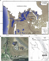
Fig. 1.
Fig. 1.. Location maps and aerial images showing the location of the Cooper’s Ferry site and excavation areas.
Paleoenvironmental conditions in the Pacific Northwest during glacial conditions at ~16,000 calibrated years before the present (cal yr B.P.) shown in (A). Aerial image of the site showing the location of Area A and Area B in relation to the Salmon River (B). Site map showing the location of Butler’s Trench and the Rock Creek Paleochannel (C). Projected regional environmental aspects at ~16,000 cal yr B.P. are based on modeled extents of Cordilleran and Laurentide glacial ice (31), mountain glacier complexes (32), positions of Glacial Lake Missoula, Glacial Lake Columbia, the modeled path of the Missoula Flood (MF) and its impoundment pool (33), smaller northern Great Basin pluvial lakes (34), and shoreline extents along the Pacific outer continental shelf (shown as a tan dotted area at left) (35). Aerial image shown in (B) shows excavations in progress on 30 July 2016 (36). masl, m above sea level.
Fig. 2.
Fig. 2.. Chronostratigraphic correlation between Area A and Area B.
Dashed lines indicate erosional surfaces. Wavy lines show areas of soil development. Black circles indicate radiocarbon ages from samples recovered in a stratigraphic unit. Radiocarbon ages without circles are from cultural features. Radiocarbon ages on LU3 samples derived from rodent burrows (1) are not shown. The vertical scale of each composite stratigraphic profile is ~3.0 m. OSL, optically stimulated luminescence. AMS- accelerator mass spectrometry.
Fig. 3.
Fig. 3.. Composite stratigraphy of Area B.
Drawing of stratigraphic units exposed along the a-a’ easting profile (A). Looking north into the deposits arranged near the a-a’ stratigraphic transect–pits F151 and F108 are positioned behind pit F78. To show this arrangement, the fill of F78 is made partially transparent. Plan view of Area B’s deepest excavation units showing distribution of pit features and trench excavation placed by Butler (B). Excavation unit numbers and quadrant designations are shown in each 1 m–by–1 m square (e.g., 23-SE).
Fig. 4.
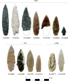
Fig. 4.. Projectile points from LUB3 sediments, pit F78, and pit F108.
Catalog numbers are shown beneath each point (e.g., 73-54185). Dashed lines show estimated extents. A small fragment of a probable stemmed point base found in F78 is not shown here.
Fig. 5.
Fig. 5.. Bayesian model for Cooper’s Ferry Area A.
This model includes 94 previously unreported radiocarbon measurements on mussel shells from LU6 and estimates the start and end of LU3 at 16,500 to 15,250 and 13,450 to 11,800 cal yr B.P., respectively, which are comparable to previous results (1). Outlier analysis output is noted as “O:posterior probability/prior probability.”
Fig. 6.
Fig. 6.. Bayesian model for Cooper’s Ferry Area B.
This model estimates the start of LUB3 at 16,045 to 15,725 cal yr B.P. Outlier analysis output is noted as “O:posterior probability/prior probability.”

References

    1. L. G. Davis, D. B. Madsen, L. Becerra-Valdivia, T. Higham, D. A. Sisson, S. M. Skinner, D. Stueber, A. J. Nyers, A. Keen-Zebert, C. Neudorf, M. Cheyney, M. Izuho, F. Iizuka, S. R. Burns, C. W. Epps, S. C. Willis, I. Buvit,Late upper paleolithic occupation at Cooper’s Ferry, Idaho, USA, ~16,000 years ago. Science 365,891–897 (2019). - PubMed
    1. JD Lancaster “Progress in the search for early sites in the lower Salmon River canyon, Idaho: A case study in geoarchaeological prospection,” thesis, Oregon State University, Corvallis (2015).
    1. L. G. Davis, K. Muehlenbachs, C. E. Schweger, N. W. Rutter,Differential response of vegetation to postglacial climate in the lower Salmon River canyon, Idaho. Palaeogeogr. Palaeoclimatol. Palaeoecol. 185,339–354 (2002).
    1. L. G. Davis “The coevolution of early hunter-gatherer culture and riparian ecosystems in the southern Columbia River Plateau,” thesis, University of Alberta, Edmonton (2001).
    1. S. J. Fiedel, B. A. Potter, J. E. Morrow, M. K. Faught, C. Vance Haynes Jr., J. C. Chatters, Pioneers from Northern Japan in Idaho 16,000 Years Ago? A Critical Evaluation of the Evidence from Cooper’s Ferry. PaleoAm. 7, 28–42 (2020).