

Tsunami Runup and Inundation in Tonga from the January 2022 Eruption of Hunga Volcano
- PMID: 36590884
- PMCID: PMC9795157
- DOI: 10.1007/s00024-022-03215-5
Tsunami Runup and Inundation in Tonga from the January 2022 Eruption of Hunga Volcano
Abstract
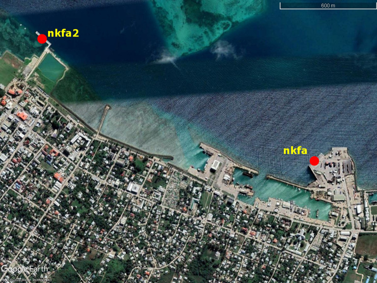
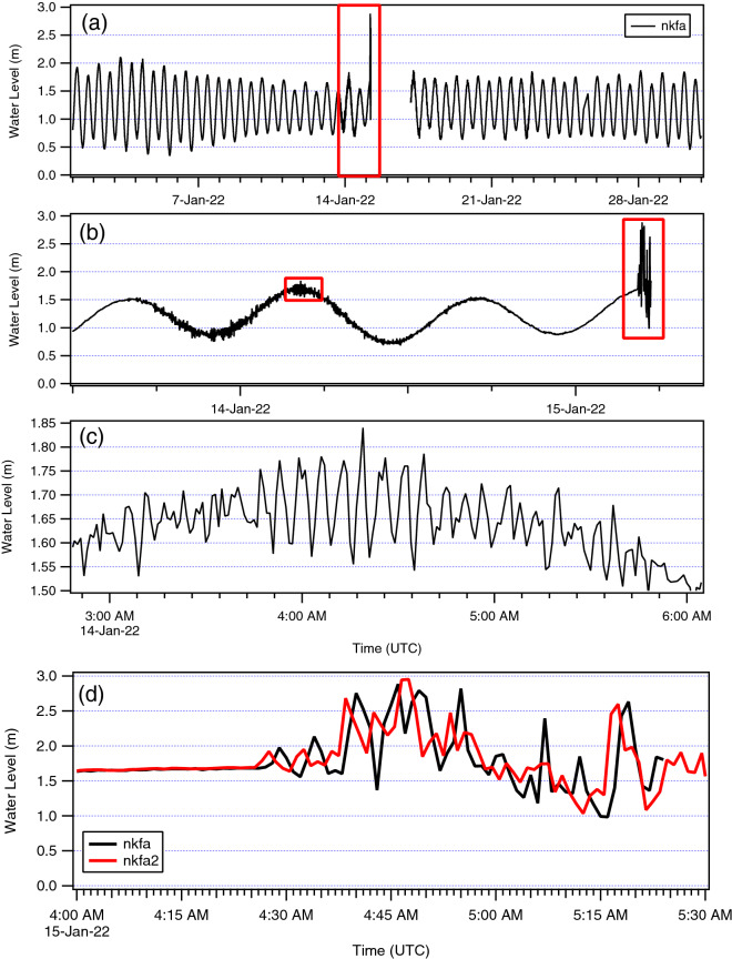
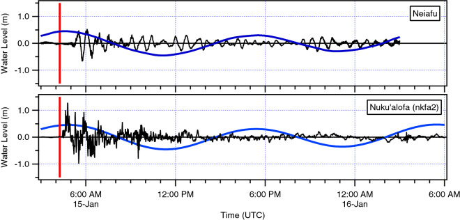
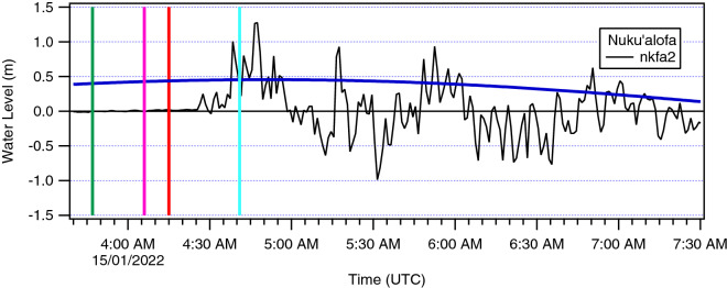
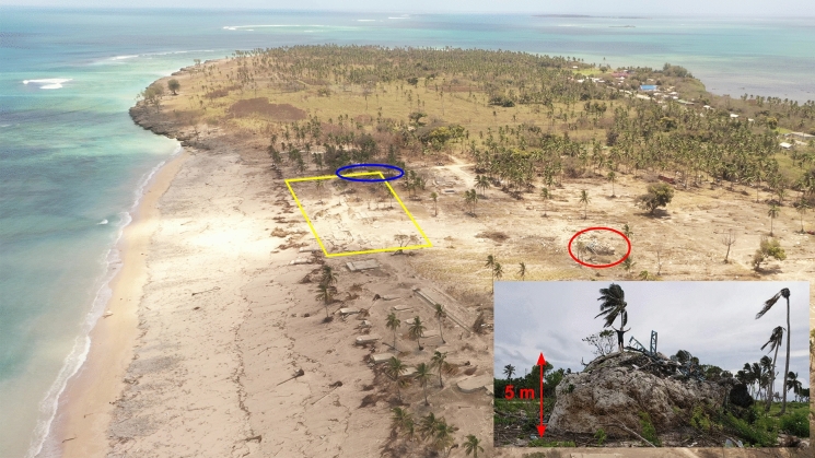
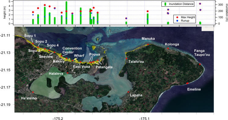
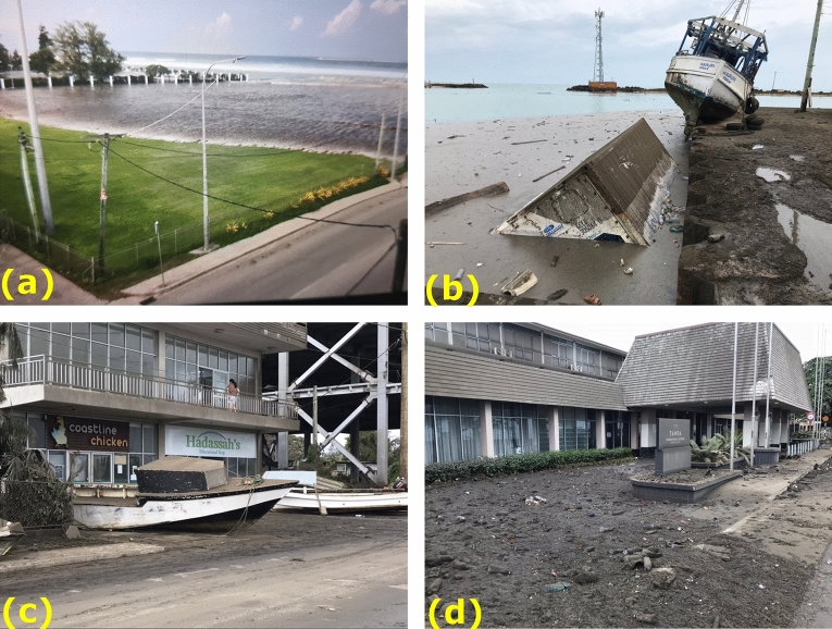
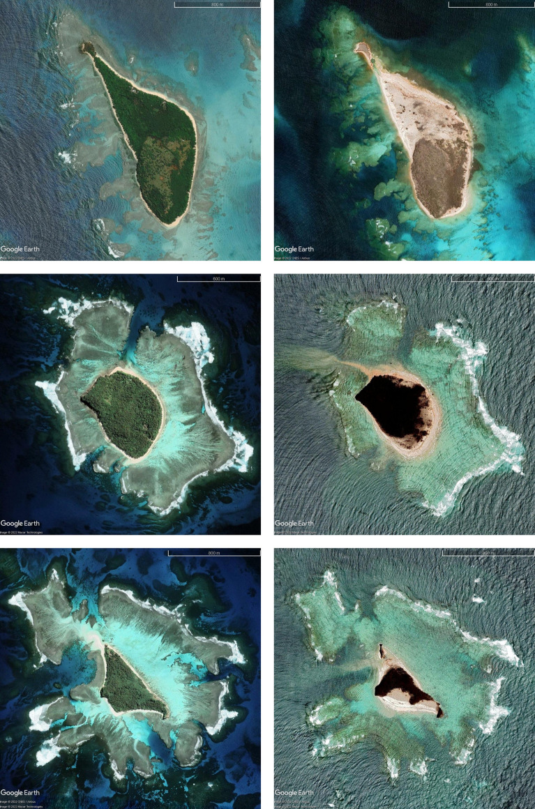
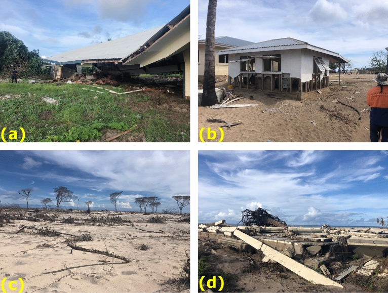
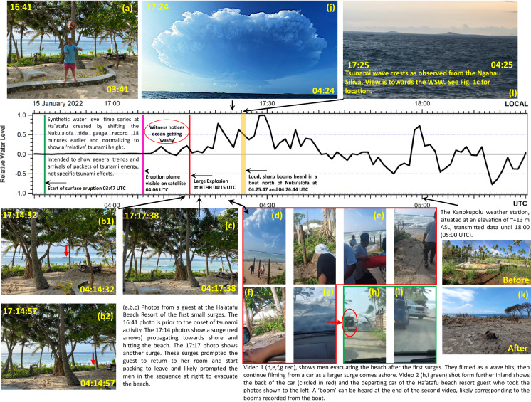
On January 15th, 2022, at approximately 4:47 pm local time (0347 UTC), several weeks of heightened activity at the Hunga volcano 65 km northwest of Tongatapu, culminated in an 11-h long violent eruption which generated a significant near-field tsunami. Although the Kingdom of Tonga lies astride a large and tsunamigenic subduction zone, it has relatively few records of significant tsunami. Assessment activities took place both remotely and locally. Between March and June 2022, a field team quantified tsunami runup and inundation on the main populated islands Tongatapu and Eua, along with several smaller islands to the north, including the Ha'apai Group. Peak tsunami heights were ~ 19 m in western Tongatapu, ~ 20 m on south-eastern Nomuka Iki island and ~ 20 m on southern Tofua, located ~ 65 km S and E and 90 km N from Hunga volcano, respectively. In western Tongatapu, the largest tsunami surge overtopped a 13-15 m-high ridge along the narrow Hihifo peninsula in several locations. Analysis of tide gauge records from Nukualofa (which lag western Tongatapu arrivals by ~ 18-20 min), suggest that initial tsunami surges were generated prior to the largest volcanic explosions at ~ 0415 UTC. Further waves were generated by ~ 0426 UTC explosions that were accompanied by air-pressure waves. Efforts to model this event are unable to reproduce the timing of the large tsunami wave that toppled a weather station and communication tower on a 13 m-high ridge on western Tongatapu after 0500 UTC. Smaller tsunami waves continued until ~ 0900, coincident with a second energetic phase of eruption, and noted by eyewitnesses on Tungua and Mango Islands. Despite an extreme level of destruction caused by this tsunami, the death toll was extraordinarily low (4 victims). Interviews with witnesses and analysis of videos posted on social media suggest that this can be attributed to the arrival of smaller 'pre tsunami' waves that prompted evacuations, heightened tsunami awareness due to tsunami activity and advisories on the day before, the absence of tourists and ongoing tsunami education efforts since the 2009 Niuatoputapu, Tonga tsunami. This event highlights an unexpectedly great hazard from volcanic tsunami worldwide, which in Tonga's case overprints an already extreme level of tectonic tsunami hazard. Education and outreach efforts should continue to emphasize the 'natural warning signs' of strong ground shaking and unusual wave and current action, and the importance of self-evacuation from coastal areas of low-lying islands. The stories of survival from this event can be used as global best practice for personal survival strategies from future tsunami.
Supplementary information: The online version contains supplementary material available at 10.1007/s00024-022-03215-5.
Keywords: Tsunamis; eyewitness; field survey; volcanic hazard and risk.
© The Author(s) 2022.
Conflict of interest statement
Conflict of InterestThe authors have no relevant financial or non-financial interests to disclose.
Figures


References
-
- Borrero, J., Greer, D., McIntosh, R. & Damlamian, H. (2021). Tsunami Hazard Assessment for Tongatapu, Tonga. Proceedings of the 2021 Australasian Coasts & Ports Conference.
-
- Borrero, J.C., Cronin, S., Latu’ila, F.H. et al. (2022). Field Survey of Runup and Inundation in Tonga from the January 2022 eruption of Hunga Tonga-Hunga Ha’apai Volcano. SPC Technical Report, December 2022.
-
- Borrero JC, Solihuddin T, Fritz HM, et al. Field survey and numerical modelling of the december 22, 2018 Anak Krakatau Tsunami. Pure and Applied Geophysics. 2020;177:2457–2475. doi: 10.1007/s00024-020-02515-y. - DOI
-
- Bosserelle, C., Lane, E., Fa'anunu, 'O. & Williams, S. (2022). Nearfield reconstruction of the Hunga Tonga-Hunga Ha'apai tsunami. Proceedings of the 2022 Asia Oceania Geoscience Society virtual conference.
-
- Carvajal M, Sepúlveda I, Gubler A, Garreaud R. Worldwide signature of the 2022 Tonga volcanic tsunami. Geophysical Research Letters. 2022 doi: 10.1029/2022GL098153. - DOI
LinkOut - more resources
Full Text Sources