Assessing impact of agroecological interventions in Niger through remotely sensed changes in vegetation
- PMID: 36611053
- PMCID: PMC9825491
- DOI: 10.1038/s41598-022-27242-3
Assessing impact of agroecological interventions in Niger through remotely sensed changes in vegetation
Abstract
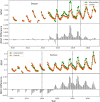
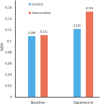
Water scarcity is a major challenge in the Sahel region of West Africa. Water scarcity in combination with prevalent soil degradation has severely reduced the land productivity in the region. The decrease in resiliency of food security systems of marginalized population has huge societal implications which often leads to mass migrations and conflicts. The U.S. Agency for International Development (USAID) and development organizations have made major investments in the Sahel to improve resilience through land rehabilitation activities in recent years. To help restore degraded lands at the farm level, the World Food Programme (WFP) with assistance from USAID's Bureau for Humanitarian Assistance supported the construction of water and soil retention structures called half-moons. The vegetation growing in the half-moons is vitally important to increase agricultural productivity and feed animals, a critical element of sustainable food security in the region. This paper investigates the effectiveness of interventions at 18 WFP sites in southern Niger using vegetative greenness observations from the Landsat 7 satellite. The pre - and post-intervention analysis shows that vegetation greenness after the half-moon intervention was nearly 50% higher than in the pre-intervention years. The vegetation in the intervened area was more than 25% greener than the nearby control area. Together, the results indicate that the half-moons are effective adaptations to the traditional land management systems to increase agricultural production in arid ecosystems, which is evident through improved vegetation conditions in southern Niger. The analysis shows that the improvement brought by the interventions continue to provide the benefits. Continued application of these adaptation techniques on a larger scale will increase agricultural production and build resilience to drought for subsistence farmers in West Africa. Quantifiable increase in efficacy of local-scale land and water management techniques, and the resulting jump in large-scale investments to scale similar efforts will help farmers enhance their resiliency in a sustainable manner will lead to a reduction in food security shortages.
© 2023. This is a U.S. Government work and not under copyright protection in the US; foreign copyright protection may apply.
Conflict of interest statement
The authors declare no competing interests.
Figures


References
-
- Copeland SM, Munson SM, Bradford JB, Butterfield BJ. Influence of climate, post-treatment weather extremes, and soil factors on vegetation recovery after restoration treatments in the southwestern us. Appl. Veg. Sci. 2019;22:85–95. doi: 10.1111/avsc.12414. - DOI
-
- Nicholson S. The nature of rainfall variability over Africa on time scales of decades to millenia. Glob. Planet. Change. 2000;26:137–158. doi: 10.1016/S0921-8181(00)00040-0. - DOI
-
- Cobo JG, Dercon G, Cadisch G. Nutrient balances in African land use systems across different spatial scales: A review of approaches, challenges and progress. Agric. Ecosyst. Environ. 2010;136:1–15. doi: 10.1016/j.agee.2009.11.006. - DOI
-
- Montfort F, et al. From land productivity trends to land degradation assessment in Mozambique: Effects of climate, human activities and stakeholder definitions. Land Degrad. Dev. 2021;32:49–65. doi: 10.1002/ldr.3704. - DOI
Publication types
MeSH terms
Substances
LinkOut - more resources
Full Text Sources

