. 2023 Jan 18;9(3):eabp8200.
doi: 10.1126/sciadv.abp8200. Epub 2023 Jan 18.

Tracking elusive and shifting identities of the global fishing fleet

Affiliations

Tracking elusive and shifting identities of the global fishing fleet

Jaeyoon Park et al. Sci Adv. .

Abstract

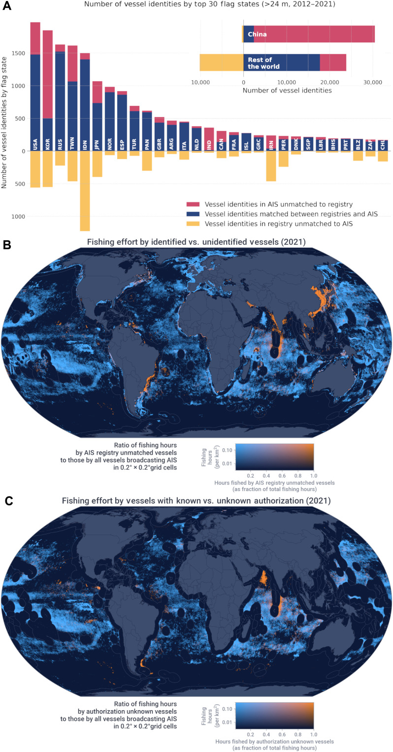
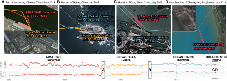
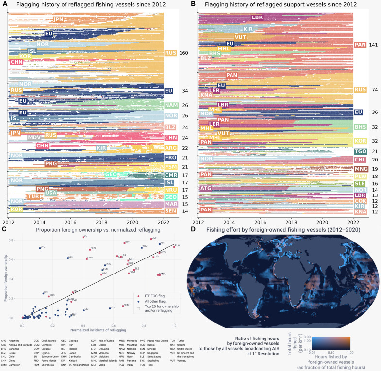
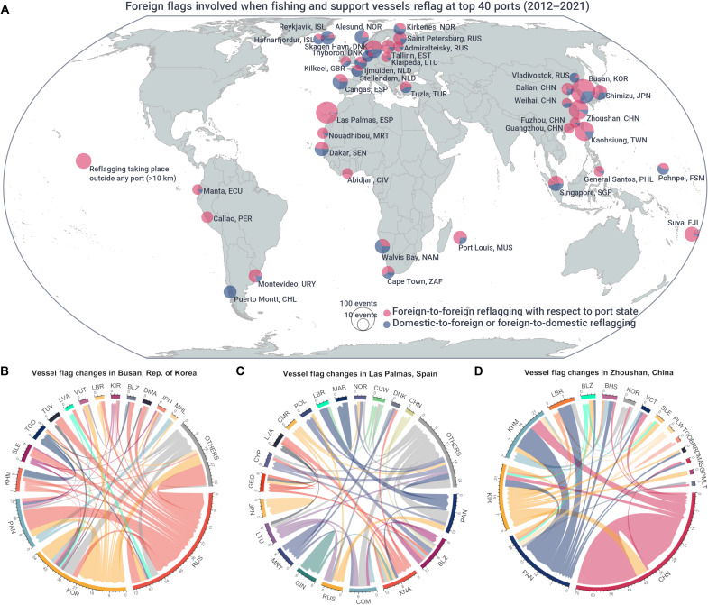
Illegal, unreported, and unregulated (IUU) fishing costs billions of dollars per year and is enabled by vessels obfuscating their identity. Here, we combine identities of ~35,000 vessels with a decade of GPS data to provide a global assessment of fishing compliance, reflagging patterns, and fishing by foreign-owned vessels. About 17% of high seas fishing is by potentially unauthorized or internationally unregulated vessels, with hot spots of this activity in the west Indian and the southwest Atlantic Oceans. In addition, reflagging, a tactic often used to obscure oversight, occurs in just a few ports primarily by fleets with high foreign ownership. Fishing by foreign-owned vessels is concentrated in parts of high seas and certain national waters, often flying flags of convenience. These findings can address the global scope of potential IUU fishing and enable authorities to improve oversight.


Figures

Fig. 1.
Fig. 1.. Publicly unidentified and potentially unauthorized fishing.
(A) For the top 30 flag states (in ISO-3166 country code, China being the first) during 2012–2021, number of fishing and support vessel identities estimated to be larger than 24 meters. Color codes correspond to (i) vessels identities matched between registries and AIS (blue), (ii) vessels identities present in AIS data but unmatched to registries (red), and (iii) vessels identities recorded in registries but unmatched to AIS data (yellow). These unmatched registry records (yellow) largely represent vessels unequipped with AIS devices but may also be due to discrepancies between identity fields in AIS and registries. See Fig. 3 for ISO-3166 country codes. (B) Fishing effort by vessels whose identity can be correlated to registry records. (C) Fishing on the high seas by vessels with known versus unknown authorization.
Fig. 2.
Fig. 2.. Tracking changes of vessel identity.
(A to D) Vessel identities associated with a hull with Vessel Record ID: IMO-8517358|IOTC-16188|WCPFC-11359 and four Google Maps providing geographical contexts of where the permanent changes in the identity of the hull take place, allowing for monitoring identity changes of individual vessels. AIS data also provide the vessel’s track from January 2012 to June 2019, when the vessel beached at Chattogram, Bangladesh to be scrapped (fig. S15). Our data also indicate that the vessel was built in Toyama, Japan, in 1987.
Fig. 3.
Fig. 3.. Patterns of reflagging.
As of 1 January 2022, flagging history of (A) fishing and (B) support vessels flying the top 15 flags each by the number of vessels. Each horizontal line with dots corresponds to a vessel hull, and each dot represents whether the vessel was active in a given week. Each dot is color-coded by flag that the vessel flies at a given time between 2012 and 2021. On the right are ISO-3166 country codes of the top 15 flags, and the numbers next to them indicate the number of vessel hulls. European Union Member States are grouped together under EU. (C) Regression analysis of the proportion of foreign ownership for a flag versus incidents of reflagging normalized by the number of distinct vessels (R2 = 0.65). Only the top 50% of flags by the number of identities registered to that flag from 2012 to 2020 are included. Flags of convenience reported by the ITF are in red, and flags in the top 20 for either foreign ownership or reflagging are marked as squares. (D) Number of estimated hours fished by vessels with foreign owners as a proportion of the total fishing.
Fig. 4.
Fig. 4.. Reflagging patterns at ports.
(A) The top 40 ports where most reflagging practices involving at least one foreign flag are identified. The size of the circle indicates the number of instances. Blue represents reflagging instances involving one foreign flag and one national flag (either previous flag or destination flag), whereas red indicates reflagging between foreign flags with respect to the flag of the port. (B to D) Each diagram represents the flow of reflagging among flag states (from the previous flag to the destination flag with a weighted arrow) at the top three foreign reflagging ports (identity changes from national flag to national flag are included for comparison). See Fig. 3 for ISO-3166 country codes.

References

    1. FAO, The State of World Fisheries and Aquaculture 2022, Towards Blue Transformation (FAO, 2022); www.fao.org/3/cc0461en/online/cc0461en.html.
    1. D. J. Agnew, J. Pearce, G. Pramod, T. Peatman, R. Watson, J. R. Beddington, T. J., Estimating the worldwide extent of illegal fishing. PLOS ONE 4, e4570 (2009). - PMC - PubMed
    1. R. A. Watson, A database of global marine commercial, small-scale, illegal and unreported fisheries catch 1950–2014. Sci. Data 4, 170039 (2017). - PMC - PubMed
    1. U. R. Sumaila, D. Zeller, L. Hood, M. L. D. Palomares, Y. Li, D. Pauly, Illicit trade in marine fish catch and its effects on ecosystems and people worldwide. Sci. Adv. 6, eaaz3801 (2020). - PMC - PubMed
    1. G. A. Petrossian, R. V. Clarke, Explaining and controlling illegal commercial fishing: An application of the CRAVED theft model. Br. J. Criminol. 54, 73–90 (2014).