. 2023 May;24(2):213-231.
doi: 10.1007/s10339-022-01122-0. Epub 2023 Jan 23.

Route effects in city-based survey knowledge estimates

Affiliations

Route effects in city-based survey knowledge estimates

Jakub Krukar et al. Cogn Process. 2023 May.

Abstract

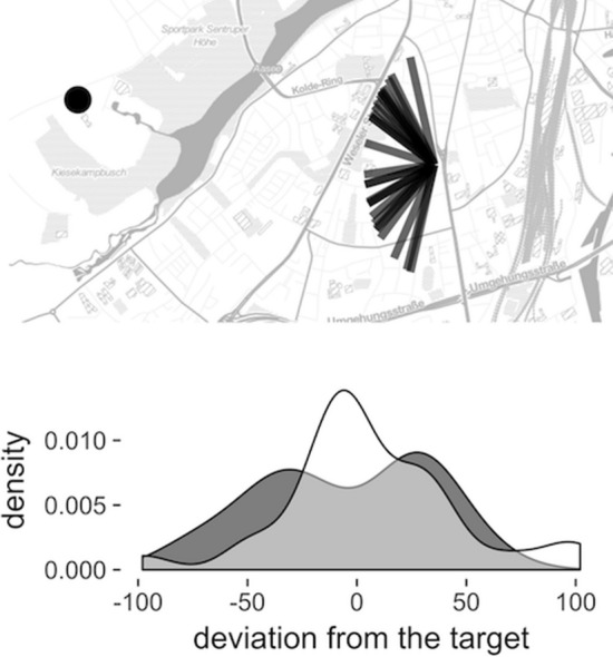
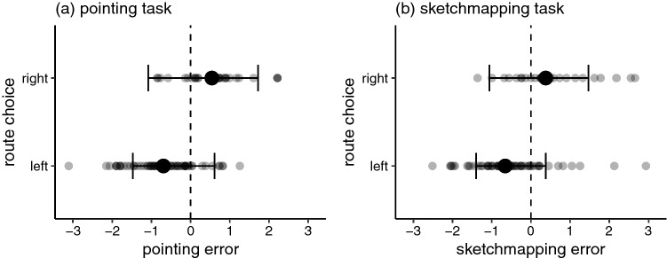
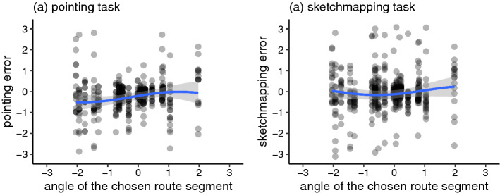
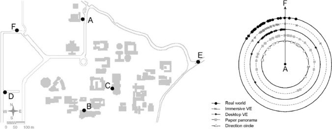
When studying wayfinding in urban environments, researchers are often interested in obtaining measures of participants' survey knowledge, i.e., their estimate of distant locations relative to other places. Previous work showed that distance estimations are consistently biased when no direct route is available to the queried target or when participants follow a detour. Here we investigated whether a corresponding bias is manifested in two other popular measures of survey knowledge: a pointing task and a sketchmapping task. The aim of this study was to investigate whether there is a systematic bias in pointing/sketchmapping performance associated with the preferred route choice in an applied urban setting. The results were mixed. We found moderate evidence for the presence of a systematic bias, but only for a subset of urban locations. When two plausible routes to the target were available, survey knowledge estimates were significantly biased in the direction of the route chosen by the participant. When only one plausible route was available, we did not find a statistically significant pattern. The results may have methodological implications for spatial cognition studies in applied urban settings that might be obtaining systematically biased survey knowledge estimates at some urban locations. Researchers should be aware that the choice of urban locations from which pointing and sketchmapping are performed might systematically distort the results, in particular when two plausible but diverging routes to the target are visible from the location.

Keywords: Direction estimation; Pointing task; Sketch maps; Survey knowledge; Urban environments.


Conflict of interest statement

The authors declare no conflicts of interest.

Figures

Fig. 1
Fig. 1
Part of the figure originally presented in Schwering et al. (2017). Top: All pointings to the zoo (indicated with a dot) made by the control group. Bottom: the comparison of the pointing distribution across the control (grey) and experimental (white) group. Note the bimodal distribution of the control group
Fig. 2
Fig. 2
The carpet used for collecting pointing estimates
Fig. 3
Fig. 3
Photographs of known city landmarks that were the targets of estimates in Experiment 1
Fig. 4
Fig. 4
A frame extracted from the 360 video used in Experiment 1. Note that this reproduction distorts the picture that was projected within the head-mounted display. In the experiment, this was experienced as a naturally looking environment surrounding the user who had to rotate their head in order to see the entire frame. The video lasted 5 minutes and played in a loop
Fig. 5
Fig. 5
Sketchmap representation of the surrounding (visible) environmental features on which participants performed the sketchmapping task. The red dot indicates participants’ location. Only building and road fragments that were visible from the location were pre-sketched
Fig. 6
Fig. 6
a Experimental location in the centre and the location of four targets on the city map. b Route choices available from the location. c Pointing and d sketchmapping estimates made by participants
Fig. 7
Fig. 7
The distributions of a pointing and b sketchmapping errors collected in the real-world (red) and VR (green) conditions
Fig. 8
Fig. 8
Panoramic photographs of the locations used in Experiment 2. Pictures of locations E and F have been brightened for the presentation in the manuscript but their visibility was flawless in the HTC VIVE headset
Fig. 9
Fig. 9
Sketchmap depictions presented in the centre of A3 paper sheets used in the sketchmapping task of Experiment 2
Fig. 10
Fig. 10
Visualisation of the model fitted to the relation of the route choice and the a pointing and b sketchmapping task results. Points indicate raw data. Larger dots indicate the mean. Models are fitted on a (-pi, pi) scale
Fig. 11
Fig. 11
Raw data from the pointing task. Only uniform path choice cases for routes that gathered more than 5 choices are plotted. The grey solid line indicates 0 (no pointing error), the red dotted line indicates circular mean, and the blue dashed line indicates the angle of the initial route segment to the given landmark. Note that for cases where the initial route segment was deviating more from the true direction (lower rows of the figure—blue dashed line further away from grey solid line), participants’ pointing tended to be biased in the same direction (red dotted line was on the same side of the grey solid line as the blue dashed line)
Fig. 12
Fig. 12
Visualisation of the model fitted to the relation of the angle of the initial route segment and the a pointing and b sketchmapping task results. Points indicate raw data. Models are fitted on a (-pi, pi) scale
Fig. 13
Fig. 13
The environment (left) and the pointing estimates (right) from location A to F that would require a leftward de-tour, obtained by Waller et al. (2004). Reproduced with permission

References

    1. Aust F, Barth M (2022) Papaja: prepare reproducible APA journal articles with R Markdown (Version 0.2.0). https://github.com/crsh/papaja (Original work published 2014)
    1. Bailenson JN, Shum MS, Uttal DH. The initial segment strategy: a heuristic for route selection. Memory Cogn. 2000;28(2):306–318. doi: 10.3758/BF03213808. - DOI - PubMed
    1. Barsalou LW. Grounded cognition. Annu Rev Psychol. 2008;59:617–645. doi: 10.1146/annurev.psych.59.103006.093639. - DOI - PubMed
    1. Brunyè TT, Gardony A, Mahoney CR, Taylor HA. Body-specific representations of spatial location. Cognition. 2012;123(2):229–239. doi: 10.1016/j.cognition.2011.07.013. - DOI - PubMed
    1. Bürkner P-C. Brms: an R package for Bayesian multilevel models using stan. J Stat Softw. 2017;80:1–28. doi: 10.18637/jss.v080.i01. - DOI

LinkOut - more resources