. 2022 Nov;13(6):101310.
doi: 10.1016/j.gsf.2021.101310. Epub 2021 Sep 28.

Use of geospatial tools to predict the risk of contamination by SARS-CoV-2 in urban cemeteries

Affiliations

Use of geospatial tools to predict the risk of contamination by SARS-CoV-2 in urban cemeteries

Paloma Carollo Toscan et al. Geosci Front. 2022 Nov.

Abstract

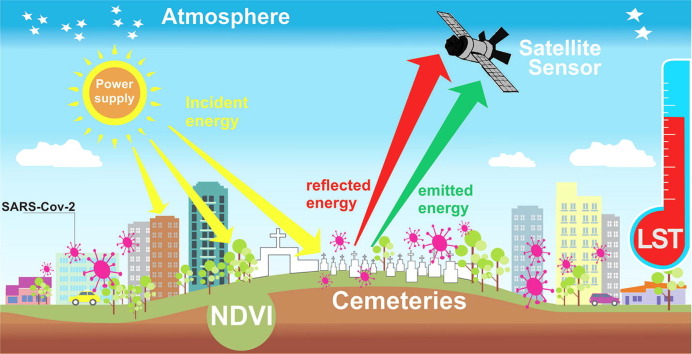
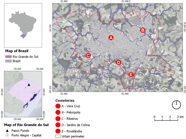
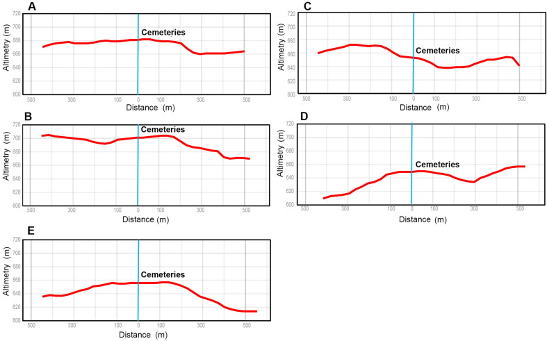
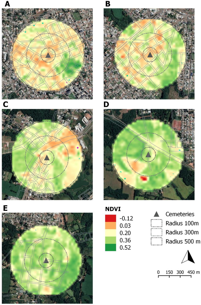
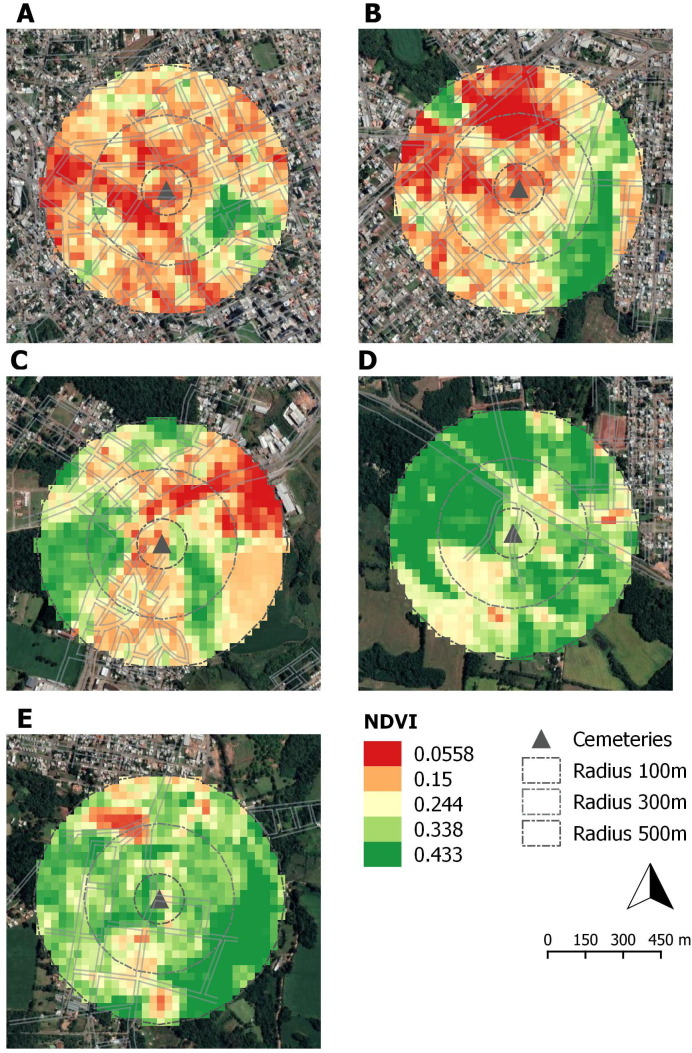
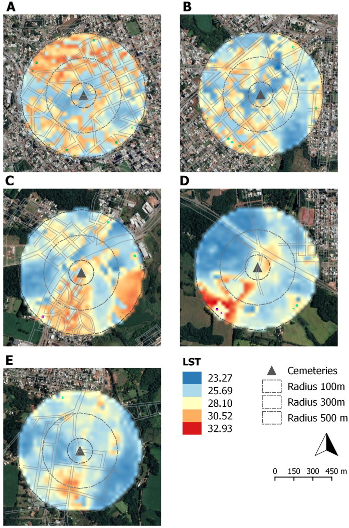
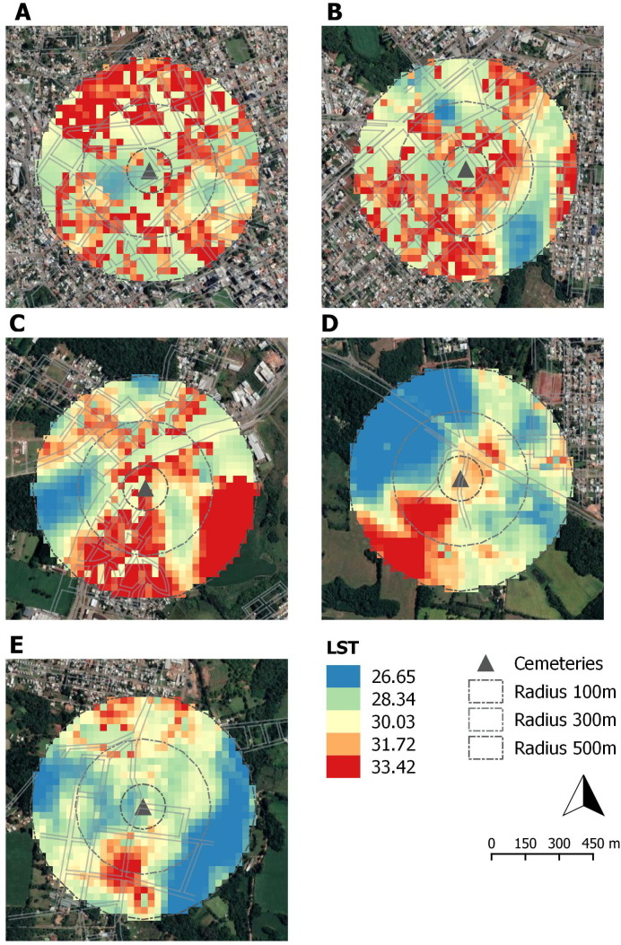
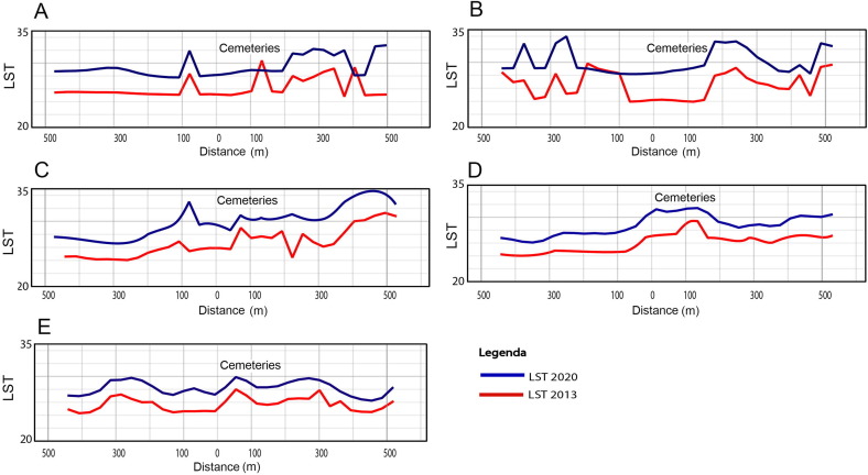
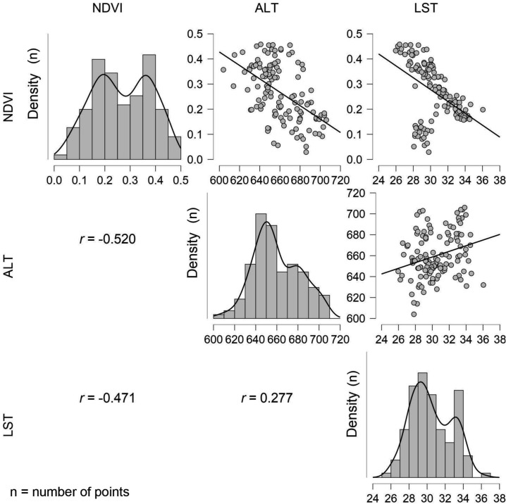
Urban cemeteries are increasingly surrounded by areas of high residential density as urbanization continues world-wide. With increasing rates of mortality caused by the novel coronavirus, SARS-CoV-2, urban vertical cemeteries are experiencing interments at an unprecedented rate. Corpses interred in the 3rd to 5th layer of vertical urban cemeteries have the potential to contaminate large adjacent regions. The general objective of this manuscript is to analyze the reflectance of altimetry, normalized difference vegetation index (NDVI) and land surface temperature (LST) in the urban cemeteries and neighbouring areas of the City of Passo Fundo, Rio Grande do Sul, Brazil. It is assumed that the population residing in the vicinity of these cemeteries may be exposed to SARS-CoV-2 contamination through the displacement of microparticles carried by the wind as a corpse is placed in the burial niche or during the first several days of subsequent fluid and gas release through the process of decomposition. The reflectance analyses were performed utilizing Landsat 8 satellite images applied to altimetry, NDVI and LST, for hypothetical examination of possible displacement, transport and subsequent deposition of the SARS-CoV-2 virus. The results showed that two cemeteries within the city, cemeteries A and B could potentially transport SARS-CoV-2 of nanometric structure to neighboring residential areas through wind action. These two cemeteries are located at high relative altitudes in more densely populated regions of the city. The NDVI, which has been shown to control the proliferation of contaminants, proved to be insufficient in these areas, contributing to high LST values. Based on the results of this study, the formation and implementation of public policies that monitor urban cemeteries is suggested in areas that utilize vertical urban cemeteries in order to reduce the further spread of the SARS-CoV-2 virus.

Keywords: Atmospheric contamination; Reflectance temperature; Remote sensing; SARS-CoV-2; Urban environment.


Conflict of interest statement

The authors declare that they have no known competing financial interests or personal relationships that could have appeared to influence the work reported in this paper.

Figures

None
Graphical abstract
Fig. 1
Fig. 1
Map of Passo Fundo, RS (southern Brazil) and its five urban cemeteries. Source: Based on data from IBGE (2021).
Fig. 2
Fig. 2
Altimetry maps, using the Landsat 8 satellite from 2020, projected on Google Earth images, applied to urban cemeteries and their surroundings (radii of 100, 300 and 500 m) in Passo Fundo / RS. Cemeteries: Vera Cruz (A), Petrópolis (B), Ribeiros (C), Jardim da Colina (D) and Roselândia (E). Source: Adapted from the IBGE database (2021), USGS (2021), with overlay on Google Earth images (2021).
Fig. 3
Fig. 3
Representation of the structure of UFPs and NPs (A) and SARS-CoV-2 (B). Source: Image representing the SARS-CoV-2 adapted from Zhu et al., 2020, Shao et al., 2021, and the representation of UFPs and NPs adapted from Oliveira et al. (2021).
Fig. 4
Fig. 4
Altimetric profiles in the period of 2020 of urban cemeteries (point Zero (0)) and their surroundings (radius of 100, 300 and 500 m) in Passo Fundo / RS. Cemeteries: Vera Cruz (A), Petrópolis (B), Ribeiros (C), Jardim da Colina (D) and Roselândia (E).
Fig. 5
Fig. 5
NDVI maps, using the Landsat 8 satellite from 2013, projected on Google Earth images, applied to urban cemeteries and their surroundings (radii of 100, 300 and 500 m) in Passo Fundo, RS. Cemeteries: Vera Cruz (A), Petrópolis (B), Ribeiros (C), Jardim da Colina (D) and Roselândia (E). Source: Adapted from the IBGE database (2021), USGS (2021), with overlay on Google Earth images (2021).
Fig. 6
Fig. 6
NDVI maps, using the Landsat 8 satellite of 2020, projected on Google Earth images, applied in urban cemeteries and their surroundings (radii of 100, 300 and 500 m) in Passo Fundo, RS. Cemeteries: Vera Cruz (A), Petrópolis (B), Ribeiros (C), Jardim da Colina (D) and Roselândia (E). Source: Adapted from the IBGE database (2021), USGS (2021), with overlay on Google Earth images (2021).
Fig. 7
Fig. 7
Comparison of 2013 and 2020 NDVI profiles of Passo Fundo’s five urban cemeteries (zero point (0)) and the surrounding (radii of 100, 300 and 500 m). Cemeteries: Vera Cruz (A), Petrópolis (B), Ribeiros (C), Jardim da Colina (D) and Roselândia (E).
Fig. 8
Fig. 8
LST maps, using the Landsat 8 satellite from 2013, projected on Google Earth images, applied to urban cemeteries and their surroundings (radii of 100, 300 and 500 m) in Passo Fundo, RS. Cemeteries: Vera Cruz (A), Petrópolis (B), Ribeiros (C), Jardim da Colina (D) and Roselândia (E). Source: Adapted from the IBGE database (2021), USGS (2021), with overlay on Google Earth images (2021).
Fig. 9
Fig. 9
LST maps, using the Landsat 8 satellite from 2020, projected on Google Earth images, applied to urban cemeteries and their surroundings (radii of 100, 300 and 500 m) in Passo Fundo, RS. Cemeteries: Vera Cruz (A), Petrópolis (B), Ribeiros (C), Jardim da Colina (D) and Roselândia (E). Source: Adapted from the IBGE database (2021), USGS (2021), with overlay on Google Earth images (2021).
Fig. 10
Fig. 10
LST profiles in the period 2013 and 2020 of urban cemeteries (point Zero (0)) and their surroundings (radii of 100, 300 and 500 m) in Passo Fundo, RS. Cemeteries: Vera Cruz (A), Petrópolis (B), Ribeiros (C), Jardim da Colina (D) and Roselândia (E).
Fig. 11
Fig. 11
Scatter plots of ALT 2020, NDVI 2013, NDVI 2020, LST 2013 and LST 2020 variables.

Similar articles

Cited by

References

    1. Abia A.L.K., Alisoltani A., Ubomba-Jaswa E., Dippenaar M.A. Microbial life beyond the grave: 16s rrna gene-based metagenomic analysis of bacteria diversity and their functional profiles in cemetery environments. Sci. Total Environ. 2019;655:831–841. - PubMed
    1. Adulkongkaew, T., Satapanajaru, T., Charoenhirunyingyos, S., Singhirunnusorn, W., 2020. Effect of land cover composition and building configuration on land surface temperature in an urban-sprawl city, case study in Bangkok Metropolitan Area, Thailand. Heliyon 6 (8), 1–13. - PMC - PubMed
    1. Ahmed T., Singh D. Probability density functions based classification of MODIS NDVI time series data and monitoring of vegetation growth cycle. Adv. Space Res. 2020;66(4):873–886.
    1. Alexander C. Normalised difference spectral indices and urban land cover as indicators of land surface temperature (LST) Int. J. Appl. Earth Obs. Geoinf. 2020;86
    1. Alexander C. Influence of the proportion, height and proximity of vegetation and buildings on urban land surface temperature. Int. J. Appl. Earth Obs. Geoinf. 2021;95:1–12.

LinkOut - more resources