

Groundwater potential mapping in Jashore, Bangladesh
- PMID: 36925550
- PMCID: PMC10011207
- DOI: 10.1016/j.heliyon.2023.e13966
Groundwater potential mapping in Jashore, Bangladesh
Abstract
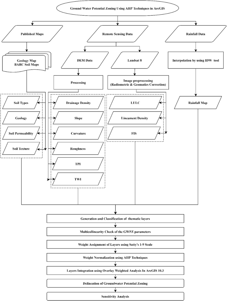
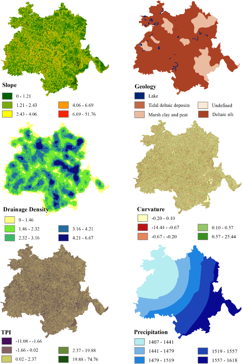
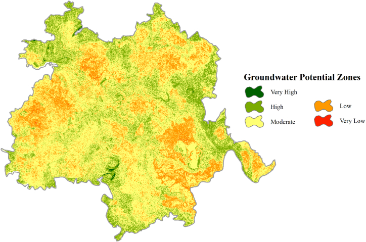
The global groundwater crisis is a perplexing issue, and for its resolution, it is of the utmost importance for delineating groundwater potential zones. This research aims to create a precise groundwater potential map for Bangladesh's Jashore district by combining geospatial approach and an analytical hierarchy process. Fourteen parameters, namely, lineament density, drainage density, land use and land cover, slope, curvature, topographic position index, topographic wetness index, rainfall, geology, roughness, fractional impervious surface, topsoil texture, soil permeability, and general soil types, were considered for the study after an extensive literature review. The weights of these parameters were determined using an analytical hierarchy process, and the scores of each sub-parameter were assigned based on published literature. The final groundwater potential map was then generated using the weighted overlay analysis tool in ArcGIS 10.3 and categorized into five classes. The analysis reveals that very high, high, moderate, low, and very low groundwater potential zones cover 3.96 km2 (0.16%), 444.75 km2 (17.72%), 1615.51 km2 (64.37%), 441.79 km2 (17.60%), and 3.59 km2 (0.14%) of the study area, respectively. The map removal sensitivity analysis shows that geology is the most significant element in groundwater potential zoning, followed by land use and land cover (LULC), slope, and topsoil texture as moderately sensitive elements. Since the groundwater potentiality zones of the study region are clearly delineated, this research may be valuable for implementing an appropriate water resource management strategy.
Keywords: Analytical hierarchy process; Bangladesh; Geographic information system; Groundwater potential zone; Remote sensing.
© 2023 The Authors.
Conflict of interest statement
The authors declare no competing interests.
Figures


References
-
- Abdalla F., Moubark K., Abdelkareem M. Groundwater potential mapping using GIS, linear weighted combination techniques and geochemical processes identification, west of the Qena area, Upper Egypt. J. Taibah Univ. Sci. 2020;14(1):1350–1362. doi: 10.1080/16583655.2020.1822646. - DOI
-
- Agarwal E., Agarwal R., Garg R.D., Garg P.K. Delineation of groundwater potential zone: an AHP/ANP approach. J. Earth Syst. Sci. 2013;122(3) doi: 10.1007/s12040-013-0309-8. - DOI
-
- Ahmed M.T., Hasan M.Y., Monir M.U., Samad M.A., Rahman M.M., Islam Rifat M.S., Islam M.N., Khan A.A.S., Biswas P.K., Jamil A.H.M.N. Evaluation of hydrochemical properties and groundwater suitability for irrigation uses in southwestern zones of Jashore, Bangladesh. Groundwater Sustain. Dev. 2020;11 doi: 10.1016/j.gsd.2020.100441. - DOI
-
- Ajay Kumar V., Mondal N.C., Ahmed S. Identification of groundwater potential zones using RS, GIS and AHP techniques: a case study in a part of Deccan Volcanic Province (DVP), Maharashtra, India. J. Ind. Soc. Remote Sens. 2020;48(3) doi: 10.1007/s12524-019-01086-3. - DOI
-
- Al-Abadi A.M., Al-Temmeme A.A., Al-Ghanimy M.A. A GIS-based combining of frequency ratio and index of entropy approaches for mapping groundwater availability zones at Badra–Al Al-Gharbi–Teeb areas, Iraq. Sustain. Water Resour. Manag. 2016;2(3):265–283. doi: 10.1007/s40899-016-0056-5. - DOI
LinkOut - more resources
Full Text Sources
